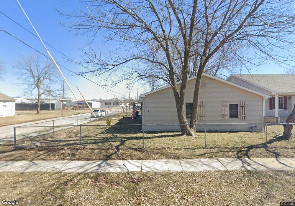
201 S Roney St Carl Junction, MO 64834
Estimated Value: $144,607 - $189,000
3
Beds
2
Baths
1,600
Sq Ft
$102/Sq Ft
Est. Value
About This Home
This home is located at 201 S Roney St, Carl Junction, MO 64834 and is currently estimated at $162,402, approximately $101 per square foot. 201 S Roney St is a home located in Jasper County with nearby schools including Carl Junction Primary School (K-1), Carl Junction Intermediate School, and Carl Junction Primary School (2-3).
Ownership History
Date
Name
Owned For
Owner Type
Purchase Details
Closed on
Aug 14, 2009
Sold by
Ziehe Deann L
Bought by
Harris Rocky Gene and Harris Carmen
Current Estimated Value
Home Financials for this Owner
Home Financials are based on the most recent Mortgage that was taken out on this home.
Original Mortgage
$72,560
Outstanding Balance
$47,357
Interest Rate
5.31%
Mortgage Type
FHA
Estimated Equity
$115,045
Purchase Details
Closed on
Mar 16, 2009
Sold by
Ziehe Deann L and Ziehe Deann
Bought by
Ziehe Deann L and Ziehe Living Trust
Create a Home Valuation Report for This Property
The Home Valuation Report is an in-depth analysis detailing your home's value as well as a comparison with similar homes in the area
Home Values in the Area
Average Home Value in this Area
Purchase History
| Date | Buyer | Sale Price | Title Company |
|---|---|---|---|
| Harris Rocky Gene | -- | Fatco | |
| Ziehe Deann L | -- | None Available |
Source: Public Records
Mortgage History
| Date | Status | Borrower | Loan Amount |
|---|---|---|---|
| Open | Harris Rocky Gene | $72,560 |
Source: Public Records
Tax History Compared to Growth
Tax History
| Year | Tax Paid | Tax Assessment Tax Assessment Total Assessment is a certain percentage of the fair market value that is determined by local assessors to be the total taxable value of land and additions on the property. | Land | Improvement |
|---|---|---|---|---|
| 2025 | $701 | $13,600 | $670 | $12,930 |
| 2024 | $666 | $11,980 | $670 | $11,310 |
| 2023 | $666 | $11,320 | $670 | $10,650 |
| 2022 | $653 | $11,070 | $670 | $10,400 |
| 2021 | $561 | $11,070 | $670 | $10,400 |
| 2020 | $459 | $8,900 | $670 | $8,230 |
| 2019 | $435 | $8,900 | $670 | $8,230 |
| 2018 | $435 | $8,910 | $0 | $0 |
| 2017 | $436 | $8,910 | $0 | $0 |
| 2016 | $432 | $8,920 | $0 | $0 |
| 2015 | $423 | $8,920 | $0 | $0 |
| 2014 | $423 | $8,920 | $0 | $0 |
Source: Public Records
Map
Nearby Homes
- 106 S Roney St
- 311 S Roney St
- TBD S Roney St
- 409 Gault St
- 409 W Gault St
- 205 Allen St
- 114 W Walton Ave
- 408 W Walton Ave
- 505 W Walton Ave
- 802 Aberdeen Ave
- 819 Delaney Dr
- 815 Delaney Dr
- 105 Summit St
- 503 Valley View
- Tract 3 Prairie Ln
- Tract 2 Prairie Ln
- Tract 1 Prairie Ln
- Tract 4 Prairie Ln
- 907 Aberdeen Ave
- 711 Prairie Ln
- 203 S Roney St Unit 209
- 203 S Roney St Unit 209
- 203 S Roney St
- 111 S Roney St
- 410 W Marshall
- 202 Cowgill St
- 202 S Cowgill St
- 107 S Roney St Unit 109
- 201 W Allen St
- 208 S Cowgill St
- 203 W Allen St Unit 2
- 105 S Roney St
- 206 Cowgill St
- 211 Cowgill St
- 210 Cowgill St
- 204 W Pennell St
- 212 S Cowgill St
- 212 Cowgill St
- 103 S Roney St
- 208 W Pennell St