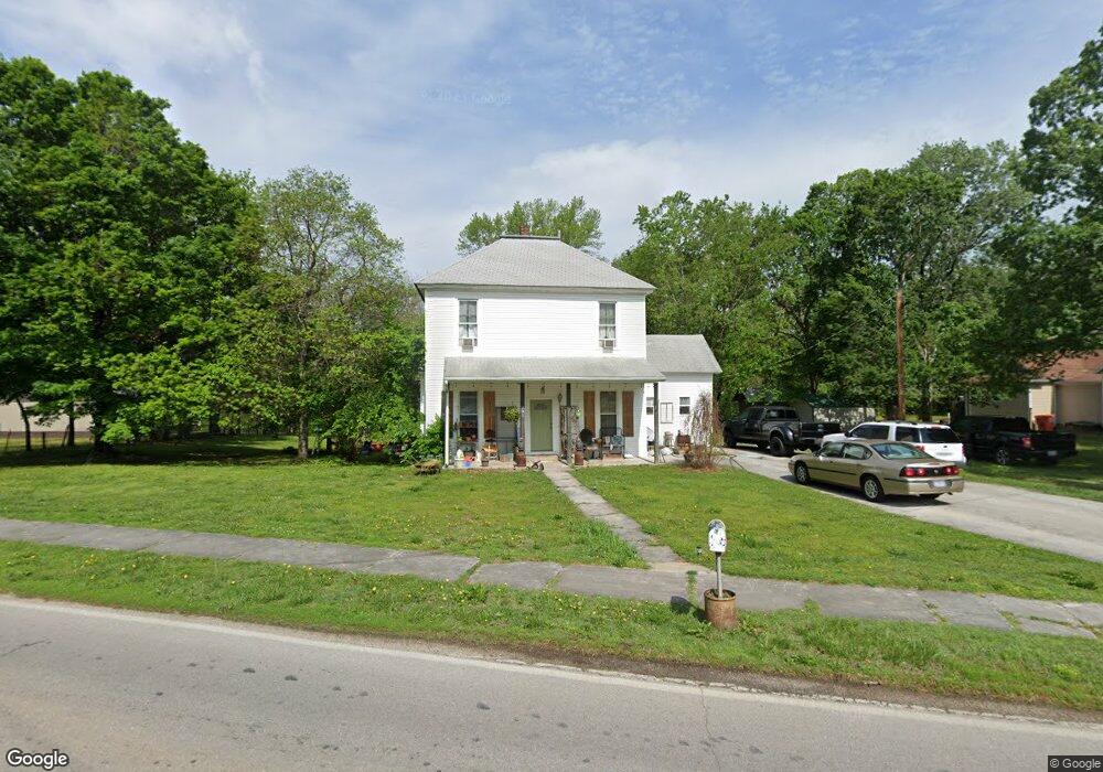
201 S State Highway F Ash Grove, MO 65604
Estimated Value: $193,000 - $250,000
4
Beds
2
Baths
1,820
Sq Ft
$120/Sq Ft
Est. Value
About This Home
This home is located at 201 S State Highway F, Ash Grove, MO 65604 and is currently estimated at $219,295, approximately $120 per square foot. 201 S State Highway F is a home located in Greene County with nearby schools including Bois D'Arc Elementary School and Ash Grove High School.
Ownership History
Date
Name
Owned For
Owner Type
Purchase Details
Closed on
Aug 25, 2014
Sold by
Card Geraldine and Card Norman L
Bought by
Card Evans Properties B Series Llc
Current Estimated Value
Purchase Details
Closed on
Nov 26, 2007
Sold by
Gilmore Dimmy and Ferwalt Gilmore Tressie L
Bought by
Card Norman L and Card Geraldine
Purchase Details
Closed on
Mar 11, 2005
Sold by
Ferwalt Richard L
Bought by
Ferwalt Tressie L
Create a Home Valuation Report for This Property
The Home Valuation Report is an in-depth analysis detailing your home's value as well as a comparison with similar homes in the area
Home Values in the Area
Average Home Value in this Area
Purchase History
| Date | Buyer | Sale Price | Title Company |
|---|---|---|---|
| Card Evans Properties B Series Llc | -- | -- | |
| Card Norman L | -- | None Available | |
| Ferwalt Tressie L | -- | None Available |
Source: Public Records
Tax History Compared to Growth
Tax History
| Year | Tax Paid | Tax Assessment Tax Assessment Total Assessment is a certain percentage of the fair market value that is determined by local assessors to be the total taxable value of land and additions on the property. | Land | Improvement |
|---|---|---|---|---|
| 2025 | $815 | $16,490 | $3,800 | $12,690 |
| 2024 | $815 | $14,060 | $2,090 | $11,970 |
| 2023 | $756 | $14,060 | $2,090 | $11,970 |
| 2022 | $770 | $13,300 | $2,090 | $11,210 |
| 2021 | $717 | $13,300 | $2,090 | $11,210 |
| 2020 | $697 | $12,750 | $2,090 | $10,660 |
| 2019 | $694 | $12,750 | $2,090 | $10,660 |
| 2018 | $681 | $12,310 | $2,090 | $10,220 |
| 2017 | $674 | $12,260 | $2,090 | $10,170 |
| 2016 | $668 | $12,260 | $2,090 | $10,170 |
| 2015 | $666 | $12,260 | $2,090 | $10,170 |
| 2014 | $652 | $12,270 | $2,090 | $10,180 |
Source: Public Records
Map
Nearby Homes
- 203 E Prairie Ln
- 300 S High Ave
- 502 W Mill St
- 103 N Maple Ln
- 606 E Prairie Ln
- 711 W Woodbine Rd
- 415 S Piper Ave
- 424 Coyote Pass
- 422 Coyote Pass
- 806 E Grant St
- 407 N Crestview Ave
- 206 E Cawlfield St
- 134 Moonlight Valley Dr
- 000 State Highway V
- Tracts 2 & 3 Farm Rd 35 & 39
- Tract Tbd W Farm Road 64
- 000 W Farm Road 64
- 6896 N Farm Road 1
- 12426 W Farm Road 60
- 7681 N Farm Road 43
- 205 S State Highway F
- 125 S Calhoun Ave
- 201 S Calhoun Ave
- 211 S State Highway F
- 200 S Calhoun Ave
- 122 S Calhoun Ave
- 120 S Calhoun Ave
- 118 S Calhoun Ave
- 206 S Calhoun Ave
- 101 S Duncan Ave
- 301 S State Highway F
- 114 S Calhoun Ave
- 303 S State Highway F
- 303 S Hwy F
- 104 S Duncan Ave
- 102 S Duncan Ave
- 117 S Calhoun Ave
- 108 S Duncan Ave
- 300 State Highway F
- 107 E Murray St