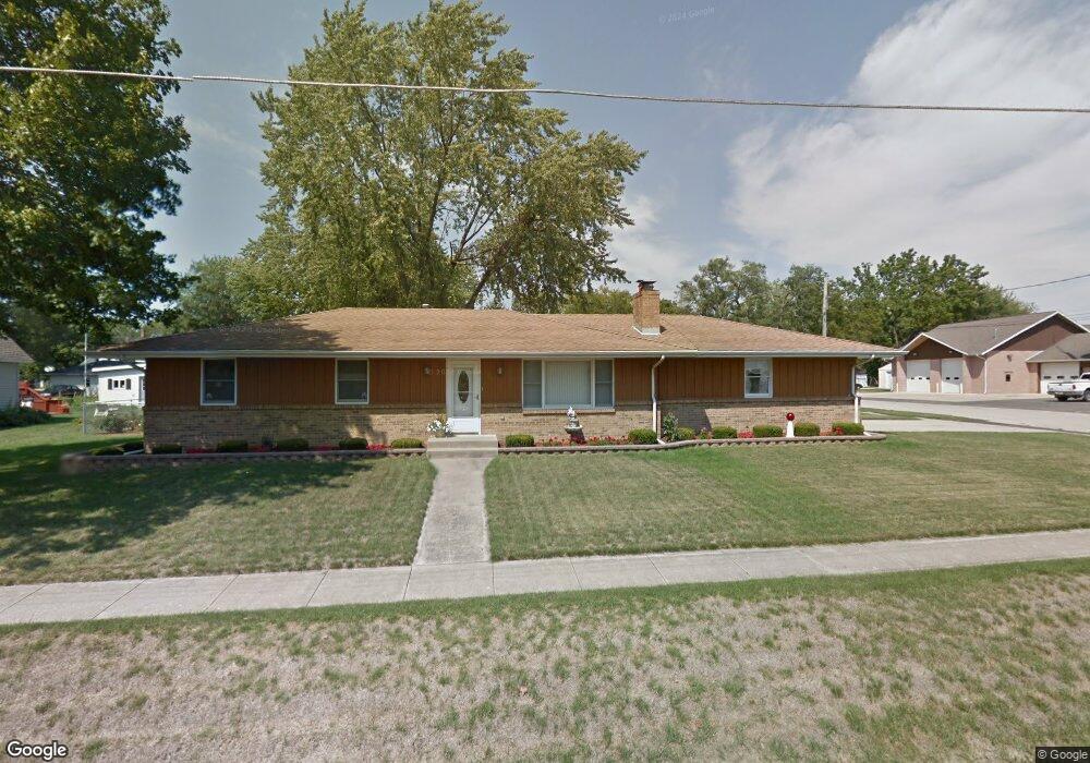
201 W Howard St Durand, IL 61024
Estimated Value: $195,516 - $242,000
--
Bed
--
Bath
--
Sq Ft
9,148
Sq Ft Lot
About This Home
This home is located at 201 W Howard St, Durand, IL 61024 and is currently estimated at $212,379. 201 W Howard St is a home located in Winnebago County with nearby schools including Durand Elementary School, Durand Junior High School, and Durand High School.
Ownership History
Date
Name
Owned For
Owner Type
Purchase Details
Closed on
Apr 13, 2018
Sold by
Renita R Rollie Living Trust
Bought by
Spelman Patrick J
Current Estimated Value
Home Financials for this Owner
Home Financials are based on the most recent Mortgage that was taken out on this home.
Original Mortgage
$112,000
Outstanding Balance
$96,739
Interest Rate
4.63%
Mortgage Type
New Conventional
Estimated Equity
$115,640
Purchase Details
Closed on
Mar 3, 1992
Bought by
Rollie Renita
Create a Home Valuation Report for This Property
The Home Valuation Report is an in-depth analysis detailing your home's value as well as a comparison with similar homes in the area
Home Values in the Area
Average Home Value in this Area
Purchase History
| Date | Buyer | Sale Price | Title Company |
|---|---|---|---|
| Spelman Patrick J | $140,000 | Security First Title | |
| Spelman Patrick J | $140,000 | Security First Title | |
| Rollie Renita | $63,500 | -- |
Source: Public Records
Mortgage History
| Date | Status | Borrower | Loan Amount |
|---|---|---|---|
| Open | Spelman Patrick J | $112,000 | |
| Closed | Spelman Patrick J | $112,000 | |
| Closed | Spelman Patrick J | $112,000 |
Source: Public Records
Tax History Compared to Growth
Tax History
| Year | Tax Paid | Tax Assessment Tax Assessment Total Assessment is a certain percentage of the fair market value that is determined by local assessors to be the total taxable value of land and additions on the property. | Land | Improvement |
|---|---|---|---|---|
| 2024 | $4,690 | $65,692 | $4,291 | $61,401 |
| 2023 | $4,215 | $56,291 | $3,677 | $52,614 |
| 2022 | $3,757 | $49,725 | $3,281 | $46,444 |
| 2021 | $3,839 | $45,787 | $3,021 | $42,766 |
| 2020 | $3,808 | $44,056 | $2,907 | $41,149 |
| 2019 | $3,742 | $42,939 | $2,833 | $40,106 |
| 2018 | $3,307 | $35,775 | $2,720 | $33,055 |
| 2017 | $3,194 | $35,074 | $2,667 | $32,407 |
| 2016 | $3,386 | $35,074 | $2,667 | $32,407 |
| 2015 | $3,387 | $35,074 | $2,667 | $32,407 |
| 2014 | $3,380 | $35,074 | $2,667 | $32,407 |
Source: Public Records
Map
Nearby Homes
- 1108 Otter Creek Dr
- 302 Mulvain St
- 211 Mulvain St
- 1306 Otter Creek Dr
- 1405 Sentry Dr
- 13755 Baker Rd
- 0 Wheeler Rd
- 000 Wheeler Rd
- 1554 Pier Dr
- 1726 Baintree Rd
- 1827 Darby Ln
- 1462 Chadbourne Dr
- 1551 Pier Dr
- 1400 Pier Dr
- 1604 Larchmont Rd
- 1305 Chadbourne Dr
- 1306 Chadbourne Dr
- 12350 Serene Dr
- 1506 Pier Dr
- 1585 Edgewood Ave