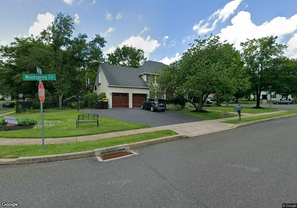
201 Woodspring Cir Doylestown, PA 18901
Estimated Value: $787,000 - $961,828
4
Beds
3
Baths
2,180
Sq Ft
$403/Sq Ft
Est. Value
About This Home
This home is located at 201 Woodspring Cir, Doylestown, PA 18901 and is currently estimated at $878,707, approximately $403 per square foot. 201 Woodspring Cir is a home located in Bucks County with nearby schools including Linden El School, Lenape Middle School, and Central Bucks High School-West.
Ownership History
Date
Name
Owned For
Owner Type
Purchase Details
Closed on
Jun 13, 2008
Sold by
Murphy Margaret and Rose Megan
Bought by
Rose Megan and Rose Michael
Current Estimated Value
Purchase Details
Closed on
Aug 1, 2003
Sold by
Edmonds Ken and Edmonds Emily
Bought by
Murphy Margaret and Rose Megan
Purchase Details
Closed on
Jul 31, 2002
Sold by
Belsky Kenneth I and Belsky Donna
Bought by
Edmonds Ken and Edmonds Emily
Create a Home Valuation Report for This Property
The Home Valuation Report is an in-depth analysis detailing your home's value as well as a comparison with similar homes in the area
Home Values in the Area
Average Home Value in this Area
Purchase History
| Date | Buyer | Sale Price | Title Company |
|---|---|---|---|
| Rose Megan | -- | None Available | |
| Murphy Margaret | $395,000 | -- | |
| Edmonds Ken | $369,500 | -- |
Source: Public Records
Tax History Compared to Growth
Tax History
| Year | Tax Paid | Tax Assessment Tax Assessment Total Assessment is a certain percentage of the fair market value that is determined by local assessors to be the total taxable value of land and additions on the property. | Land | Improvement |
|---|---|---|---|---|
| 2025 | $9,482 | $53,580 | $8,720 | $44,860 |
| 2024 | $9,482 | $53,580 | $8,720 | $44,860 |
| 2023 | $9,041 | $53,580 | $8,720 | $44,860 |
| 2022 | $8,940 | $53,580 | $8,720 | $44,860 |
| 2021 | $8,756 | $53,580 | $8,720 | $44,860 |
| 2020 | $8,716 | $53,580 | $8,720 | $44,860 |
| 2019 | $8,622 | $53,580 | $8,720 | $44,860 |
| 2018 | $8,596 | $53,580 | $8,720 | $44,860 |
| 2017 | $8,529 | $53,580 | $8,720 | $44,860 |
| 2016 | $8,475 | $53,580 | $8,720 | $44,860 |
| 2015 | -- | $53,580 | $8,720 | $44,860 |
| 2014 | -- | $53,580 | $8,720 | $44,860 |
Source: Public Records
Map
Nearby Homes
- 195 Lafayette St
- 3 Steeplechase Dr
- 403 S Main St Unit S201
- 236 Green St
- 89 Homestead Dr
- 37 N Clinton St
- 110 E Ashland St
- 272 Fox Chase Ln
- 69 E Oakland Ave
- 9 Mill Creek Dr
- 130 N Clinton St
- 20 E Court St
- 1 Barnes Ct
- 155 E Oakland Ave
- 78 Tower Hill Rd
- 146 E Court St
- 146 N Church St
- 114 Progress Dr
- 32 Hibiscus Ct Unit 32
- 339 E Ashland St
- 203 Woodspring Cir
- 200 Woodspring Cir
- 169 Hart Ave
- 205 Woodspring Cir
- 170 Hart Ave
- 174 Hart Ave
- 202 Woodspring Cir
- 207 Woodspring Cir
- 176 Hart Ave
- 171 Hart Ave
- 206 Woodspring Cir
- 353 Birdsong Way
- 204 Woodspring Cir
- 167 Hart Ave
- 355 Birdsong Way
- 200 S Clinton St
- 352 Birdsong Way
- 165 Hart Ave
- 357 Birdsong Way
- 354 Birdsong Way