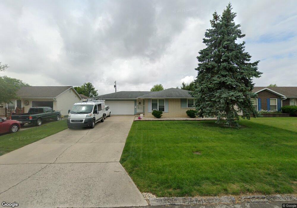
201 Woodstock Dr van Wert, OH 45891
Estimated Value: $144,933 - $161,000
4
Beds
2
Baths
1,152
Sq Ft
$134/Sq Ft
Est. Value
About This Home
This home is located at 201 Woodstock Dr, van Wert, OH 45891 and is currently estimated at $153,983, approximately $133 per square foot. 201 Woodstock Dr is a home located in Van Wert County with nearby schools including Van Wert Early Childhood Center, Van Wert High School, and Lifelinks Community School.
Ownership History
Date
Name
Owned For
Owner Type
Purchase Details
Closed on
Apr 21, 2016
Sold by
Agler Leigh A
Bought by
Shields Brian Matthews and Shields Andrea Renee
Current Estimated Value
Home Financials for this Owner
Home Financials are based on the most recent Mortgage that was taken out on this home.
Original Mortgage
$60,000
Outstanding Balance
$47,744
Interest Rate
3.73%
Mortgage Type
New Conventional
Estimated Equity
$106,239
Purchase Details
Closed on
Jun 19, 2008
Sold by
Estate Of Dallas E Agler
Bought by
Agler Leigh A
Purchase Details
Closed on
Apr 29, 2004
Bought by
Shields Brian Matthew
Create a Home Valuation Report for This Property
The Home Valuation Report is an in-depth analysis detailing your home's value as well as a comparison with similar homes in the area
Home Values in the Area
Average Home Value in this Area
Purchase History
| Date | Buyer | Sale Price | Title Company |
|---|---|---|---|
| Shields Brian Matthews | $75,000 | None Available | |
| Agler Leigh A | -- | None Available | |
| Shields Brian Matthew | $75,000 | -- |
Source: Public Records
Mortgage History
| Date | Status | Borrower | Loan Amount |
|---|---|---|---|
| Open | Shields Brian Matthews | $60,000 |
Source: Public Records
Tax History Compared to Growth
Tax History
| Year | Tax Paid | Tax Assessment Tax Assessment Total Assessment is a certain percentage of the fair market value that is determined by local assessors to be the total taxable value of land and additions on the property. | Land | Improvement |
|---|---|---|---|---|
| 2024 | $1,175 | $34,710 | $4,800 | $29,910 |
| 2023 | $1,175 | $34,710 | $4,800 | $29,910 |
| 2022 | $983 | $25,190 | $2,890 | $22,300 |
| 2021 | $957 | $25,190 | $2,890 | $22,300 |
| 2020 | $955 | $25,190 | $2,890 | $22,300 |
| 2019 | $853 | $22,060 | $2,890 | $19,170 |
| 2018 | $833 | $22,060 | $2,890 | $19,170 |
| 2017 | $833 | $22,060 | $2,890 | $19,170 |
| 2016 | $467 | $21,840 | $2,890 | $18,950 |
| 2015 | $467 | $21,840 | $2,890 | $18,950 |
| 2014 | $462 | $21,840 | $2,890 | $18,950 |
| 2013 | $497 | $21,840 | $2,890 | $18,950 |
Source: Public Records
Map
Nearby Homes
- 1055 Westchester Ct
- 1028 Westchester Ct
- 927 Woodland Ave
- 1213 David St
- 1006 Hughes St
- 218 Burt St
- 729 George St
- 706 Woodland Ave
- 1421 Krendl Dr
- 736 Leeson Ave
- 510 Euclid Ave
- 9188 John Brown Rd Unit Lot 37
- 9188 John Brown Rd Unit Lot 7
- 9188 John Brown Rd Unit LOT 60
- 9188 John Brown Rd Unit LOT 15
- 1006 Kear Rd
- 902 Kear Rd
- 603 Pewterboy Ave
- 829 Allingham St
- 522 South Ave
- 207 Woodstock Dr
- 195 Woodstock Dr
- 189 Woodstock Dr
- 210 Woodstock Dr
- 1070 Westchester Ct
- 213 Woodstock Dr
- 216 Woodstock Dr
- 190 Woodstock Dr
- 196 Kenwick Dr
- 183 Woodstock Dr
- 219 Woodstock Dr
- 1064 Westchester Ct
- 184 Kenwick Dr
- 220 Kenwick Dr
- 220 Woodstock Dr
- 178 Kenwick Dr
- 1058 Westchester Ct
- 224 Woodstock Dr
- 195 Biltmore Ave