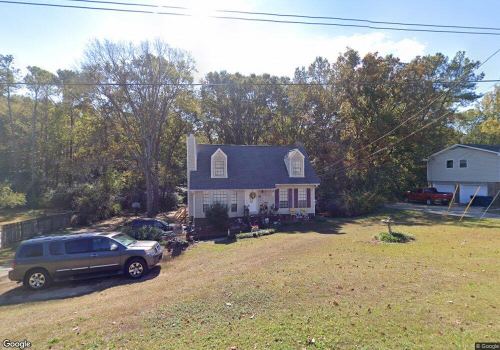
2010 1st Ave W Maylene, AL 35114
Estimated Value: $219,000 - $357,000
Studio
1
Bath
1,212
Sq Ft
$224/Sq Ft
Est. Value
About This Home
This home is located at 2010 1st Ave W, Maylene, AL 35114 and is currently estimated at $271,199, approximately $223 per square foot. 2010 1st Ave W is a home located in Shelby County with nearby schools including Thompson Intermediate School, Thompson Middle School, and Thompson High School.
Ownership History
Date
Name
Owned For
Owner Type
Purchase Details
Closed on
Apr 12, 2023
Sold by
Slusher Timothy Adam and Slusher Kristi
Bought by
Slusher-Koester Monika and Koester William
Current Estimated Value
Home Financials for this Owner
Home Financials are based on the most recent Mortgage that was taken out on this home.
Original Mortgage
$168,905
Interest Rate
6.39%
Mortgage Type
FHA
Purchase Details
Closed on
Sep 21, 2001
Sold by
Glassco Margaret B
Bought by
Slusher Timothy A and Slusher Monika W
Home Financials for this Owner
Home Financials are based on the most recent Mortgage that was taken out on this home.
Original Mortgage
$108,300
Interest Rate
6.89%
Mortgage Type
FHA
Create a Home Valuation Report for This Property
The Home Valuation Report is an in-depth analysis detailing your home's value as well as a comparison with similar homes in the area
Home Values in the Area
Average Home Value in this Area
Purchase History
| Date | Buyer | Sale Price | Title Company |
|---|---|---|---|
| Slusher-Koester Monika | $6,495 | None Listed On Document | |
| Slusher Timothy A | $110,000 | -- |
Source: Public Records
Mortgage History
| Date | Status | Borrower | Loan Amount |
|---|---|---|---|
| Previous Owner | Slusher-Koester Monika | $168,905 | |
| Previous Owner | Slusher Timothy A | $108,300 |
Source: Public Records
Tax History
| Year | Tax Paid | Tax Assessment Tax Assessment Total Assessment is a certain percentage of the fair market value that is determined by local assessors to be the total taxable value of land and additions on the property. | Land | Improvement |
|---|---|---|---|---|
| 2024 | $960 | $17,780 | $0 | $0 |
| 2023 | $975 | $18,820 | $0 | $0 |
| 2022 | $906 | $17,540 | $0 | $0 |
| 2021 | $802 | $15,620 | $0 | $0 |
| 2020 | $697 | $13,660 | $0 | $0 |
| 2019 | $672 | $13,200 | $0 | $0 |
| 2017 | $626 | $12,360 | $0 | $0 |
| 2015 | $604 | $11,940 | $0 | $0 |
| 2014 | $590 | $11,680 | $0 | $0 |
Source: Public Records
Map
Nearby Homes
- 2001 1st Ave W
- 124 Kingsley Rd
- 109 Kingsley Cir
- 120 Mayfair Park
- 306 Mayfair Cir
- 542 Navajo Trail
- 630 Navajo Trail
- 221 Queens Gate
- 1349 Old Boston Rd
- 208 Queens Gate
- 537 Ramsgate Dr
- 920 Independence Dr
- 501 Ramsgate Dr
- 236 Queens Gate
- 1317 Old Boston Rd
- 544 Ramsgate Dr
- 309 Cedar Grove Ct
- 305 Cedar Grove Ct
- 545 Ramsgate Dr
- 549 Ramsgate Dr
- 2008 1st Ave W
- 2012 1st Ave W
- 2014 1st Ave W
- 2006 1st Ave W
- 0 1st Ave W
- 2009 1st Ave W
- 2016 1st Ave W
- 22 Lucas Ln
- 2004 1st Ave W
- 113 Kingsley Ct
- 117 Kingsley Ct
- 105 Kingsley Ct
- 201 Stoney Trail Unit 14
- 201 Stoney Trail
- 2002 1st Ave W
- 2005 1st Ave W
- 2002 1st Ave
- 2018 1st Ave W
- 121 Kingsley Ct
- 101 Kingsley Ct
Your Personal Tour Guide
Ask me questions while you tour the home.