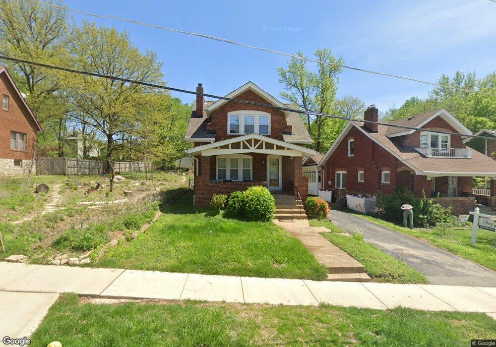
2010 Del Norte Ave Saint Louis, MO 63117
Estimated Value: $277,000 - $305,000
2
Beds
1
Bath
1,099
Sq Ft
$263/Sq Ft
Est. Value
About This Home
This home is located at 2010 Del Norte Ave, Saint Louis, MO 63117 and is currently estimated at $288,597, approximately $262 per square foot. 2010 Del Norte Ave is a home located in St. Louis County with nearby schools including Maplewood Richmond Heights Elementary School, Maplewood Richmond Heights Middle School, and Maplewood-Richmond Heights High School.
Ownership History
Date
Name
Owned For
Owner Type
Purchase Details
Closed on
Sep 10, 2009
Sold by
Smith Mildred R
Bought by
K & G Rental Properties Llc
Current Estimated Value
Home Financials for this Owner
Home Financials are based on the most recent Mortgage that was taken out on this home.
Original Mortgage
$100,000
Outstanding Balance
$65,632
Interest Rate
5.26%
Mortgage Type
Future Advance Clause Open End Mortgage
Estimated Equity
$222,965
Create a Home Valuation Report for This Property
The Home Valuation Report is an in-depth analysis detailing your home's value as well as a comparison with similar homes in the area
Home Values in the Area
Average Home Value in this Area
Purchase History
| Date | Buyer | Sale Price | Title Company |
|---|---|---|---|
| K & G Rental Properties Llc | $110,000 | Atc |
Source: Public Records
Mortgage History
| Date | Status | Borrower | Loan Amount |
|---|---|---|---|
| Open | K & G Rental Properties Llc | $100,000 |
Source: Public Records
Tax History Compared to Growth
Tax History
| Year | Tax Paid | Tax Assessment Tax Assessment Total Assessment is a certain percentage of the fair market value that is determined by local assessors to be the total taxable value of land and additions on the property. | Land | Improvement |
|---|---|---|---|---|
| 2025 | $3,573 | $50,270 | $34,560 | $15,710 |
| 2024 | $3,573 | $46,510 | $19,910 | $26,600 |
| 2023 | $3,541 | $46,510 | $19,910 | $26,600 |
| 2022 | $3,153 | $38,260 | $23,900 | $14,360 |
| 2021 | $3,098 | $38,260 | $23,900 | $14,360 |
| 2020 | $3,389 | $39,730 | $21,510 | $18,220 |
| 2019 | $3,362 | $39,730 | $21,510 | $18,220 |
| 2018 | $2,769 | $29,620 | $12,580 | $17,040 |
| 2017 | $2,750 | $29,620 | $12,580 | $17,040 |
| 2016 | $2,520 | $26,150 | $11,630 | $14,520 |
| 2015 | $2,369 | $26,150 | $11,630 | $14,520 |
| 2014 | $2,911 | $32,300 | $10,050 | $22,250 |
Source: Public Records
Map
Nearby Homes
- 7400 Williams Ave
- 2024 Bellevue Ave
- 7264 Richmond Place
- 7129 Glades Ave
- 2049 Blendon Place
- 2029 Blendon Place
- 2117 Yale Ave
- 2213 Yale Ave
- 2010 Blendon Place
- 1723 Mccready Ave
- 7342 Dale Ave
- 7590 W Bruno Ave
- 7027 Plateau Ave
- 2052 Mccausland Ave
- 7555 Alicia Ave
- 2522 Bellevue Ave
- 2118 Mccausland Ave
- 1338 Sunset Ave
- 7615 W Bruno Ave
- 2030 Bland Place
- 1736 Del Norte Ave
- 2012 Del Norte Ave
- 1734 Del Norte Ave
- 2014 Del Norte Ave
- 2016 Del Norte Ave
- 1732 Del Norte Ave
- 2018 Del Norte Ave
- 1730 Del Norte Ave
- 1809 Princeton Place
- 1807 Princeton Place
- 1807 Princeton Place Unit 1F
- 1811 Princeton Place
- 2020 Del Norte Ave
- 1805 Princeton Place
- 1813 Princeton Place
- 1815 Princeton Place
- 1803 Princeton Place
- 1728 Del Norte Ave
- 1733 Del Norte Ave
- 1731 Del Norte Ave