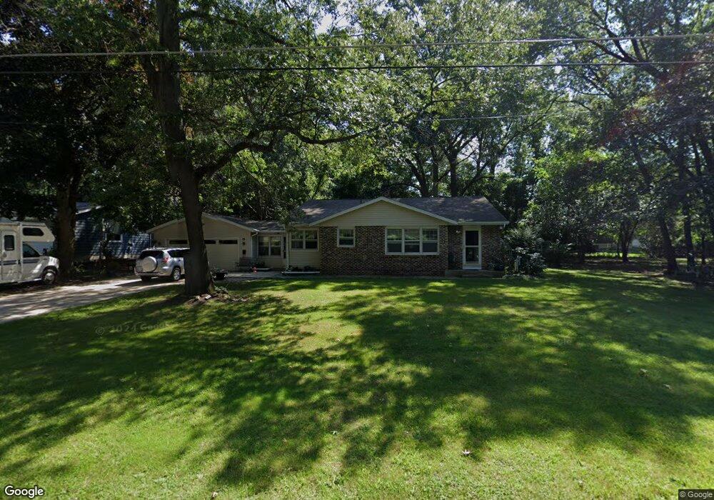
2010 Harbor Inn St Holland, MI 49424
Estimated Value: $348,174 - $451,000
3
Beds
1
Bath
1,537
Sq Ft
$270/Sq Ft
Est. Value
About This Home
This home is located at 2010 Harbor Inn St, Holland, MI 49424 and is currently estimated at $415,044, approximately $270 per square foot. 2010 Harbor Inn St is a home located in Ottawa County with nearby schools including Lakewood Elementary School, Macatawa Bay Middle School, and West Ottawa High School.
Ownership History
Date
Name
Owned For
Owner Type
Purchase Details
Closed on
Sep 12, 2016
Sold by
Barrett Richard and Barrett Sandra Lucille
Bought by
Barrett Brian D and Barrett Chad A
Current Estimated Value
Purchase Details
Closed on
Jun 30, 2005
Sold by
Hoving Patricia Joy
Bought by
Barrett Richard and Barrett Sandy
Home Financials for this Owner
Home Financials are based on the most recent Mortgage that was taken out on this home.
Original Mortgage
$96,000
Interest Rate
5.75%
Mortgage Type
Fannie Mae Freddie Mac
Create a Home Valuation Report for This Property
The Home Valuation Report is an in-depth analysis detailing your home's value as well as a comparison with similar homes in the area
Home Values in the Area
Average Home Value in this Area
Purchase History
| Date | Buyer | Sale Price | Title Company |
|---|---|---|---|
| Barrett Brian D | -- | Attorney | |
| Barrett Richard | $186,000 | Chicago Title |
Source: Public Records
Mortgage History
| Date | Status | Borrower | Loan Amount |
|---|---|---|---|
| Closed | Barrett Richard | $96,000 |
Source: Public Records
Tax History Compared to Growth
Tax History
| Year | Tax Paid | Tax Assessment Tax Assessment Total Assessment is a certain percentage of the fair market value that is determined by local assessors to be the total taxable value of land and additions on the property. | Land | Improvement |
|---|---|---|---|---|
| 2025 | $2,741 | $174,500 | $0 | $0 |
| 2024 | $2,151 | $144,000 | $0 | $0 |
| 2023 | $2,076 | $137,800 | $0 | $0 |
| 2022 | $2,460 | $120,300 | $0 | $0 |
| 2021 | $2,393 | $112,100 | $0 | $0 |
| 2020 | $2,391 | $104,300 | $0 | $0 |
| 2019 | $2,343 | $90,300 | $0 | $0 |
| 2018 | $2,181 | $95,500 | $0 | $0 |
| 2017 | $2,146 | $95,500 | $0 | $0 |
| 2016 | $2,134 | $86,500 | $0 | $0 |
| 2015 | -- | $75,700 | $0 | $0 |
| 2014 | -- | $71,500 | $0 | $0 |
Source: Public Records
Map
Nearby Homes
- 2063 Ottawa Beach Rd
- 2170 Eagle Blvd
- 2103 Woodlark Dr
- 80 S 168th Ave
- 98 Algonquin Ave
- 210 Timbercrest Ct
- 52 Navajo Ave
- 1763 Ottawa Beach Rd Unit 3
- 94 Cheyenne Ave
- 1745 Ottawa Beach Rd Unit 3
- 1745 Ottawa Beach Rd Unit 6
- 1729 Waukazoo Dr
- 2245 Perry St
- 1559 Post Ave
- 186 Tiffany Ridge Dr
- 1933 S Shore Dr
- 1761 S Shore Dr
- 1992 S Shore Dr Unit 2
- 1992 S Shore Dr Unit 3
- 1982 S Shore Dr Unit 2
- 2020 Harbor Inn St
- 0 Harbor Inn St
- 2033 Chapel Ln Unit 44
- 2000 Harbor Inn St
- 2030 Harbor Inn St
- 2027 Chapel Ln Unit 45
- 2039 Chapel Ln Unit 4143
- 2039 Chapel Ln Unit 43
- 2013 Harbor Inn St
- 2003 Harbor Inn St
- 2040 Harbor Inn St
- 2045 Chapel Ln Unit 4143
- 2045 Chapel Ln Unit 42
- 2025 Harbor Inn St
- 2023 Chapel Ln
- 1984 Harbor Inn St
- 336 Scouts Hill Unit 16
- 1993 Harbor Inn St
- 2035 Harbor Inn St
- 2051 Chapel Ln Unit 4143