
Seller's Agent in 2020
Debbie Fulford
Re/Max Of Albany
6 in this area
155 Total Sales
Estimated Value: $212,000 - $225,000
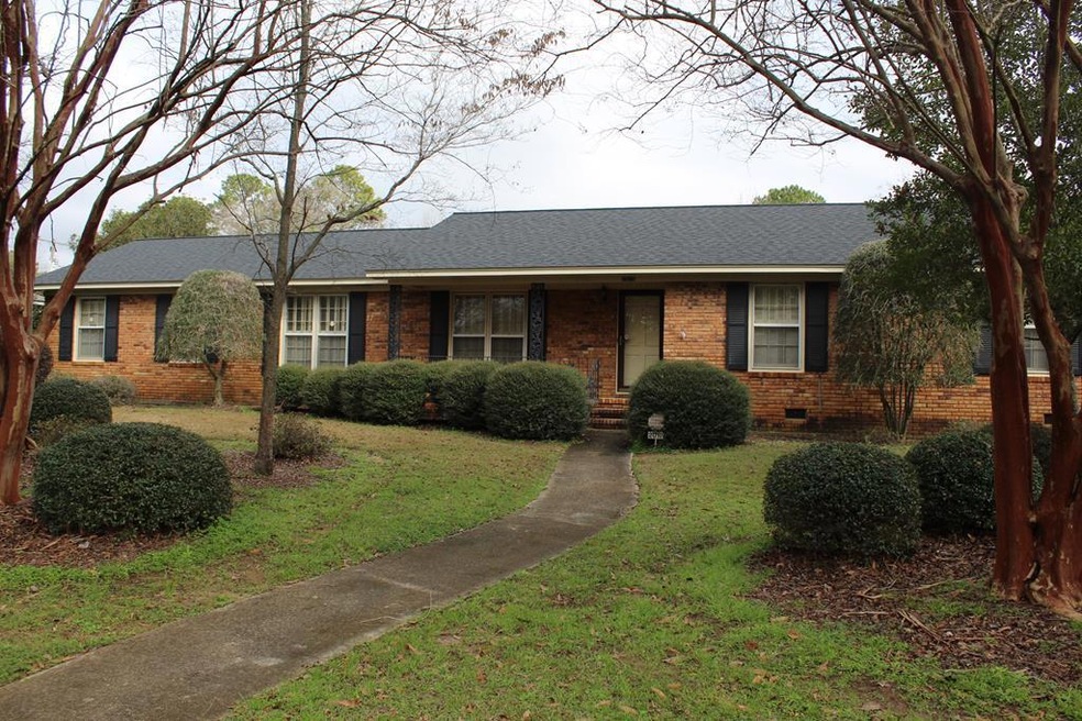
PREVIOUS BUYER'S LOAN FELL THROUGH - BACK ON MARKET NOW AT $119,500! In Lake Park School District in the heart of NW Albany. Owner of many years offers her home in great neighborhood. Lots of space - this home offers separate living room, dining room, den, and large bonus room or coud be used as 4th bedroom. Hardwood floors under bedroom carpet. All brick with vinyl exterior trim for low maintenance. New architectural roof, beautifully landscaped rear shows years of owner's love for her yard. Large wired workshop/storage building with overhead doors ideal for small business owner such as lawn care business, etc., fenced rear yard, covered patio and parking, paved alley. Great value now at $119,500. Call your agent to see.
Last Agent to Sell the Property
Re/Max Of Albany Brokerage Phone: 2294341600 License #127976 Listed on: 05/14/2020
Last Buyer's Agent
Re/Max Of Albany Brokerage Phone: 2294341600 License #127976 Listed on: 05/14/2020
| Date | Buyer | Sale Price | Title Company |
|---|---|---|---|
| Wright Victor | $117,000 | -- | |
| Landon Irrev Tr | -- | -- | |
| Landon Sulynn | -- | -- | |
| Hatcher Swales Sharyn Hatcher | -- | -- | |
| Hatcher Lula G | -- | -- | |
| Hatcher Cranford | -- | -- |
| Date | Event | Price | List to Sale | Price per Sq Ft |
|---|---|---|---|---|
| 06/29/2020 06/29/20 | Sold | $117,000 | -- | $56 / Sq Ft |
| 05/14/2020 05/14/20 | Pending | -- | -- | -- |
| Year | Tax Paid | Tax Assessment Tax Assessment Total Assessment is a certain percentage of the fair market value that is determined by local assessors to be the total taxable value of land and additions on the property. | Land | Improvement |
|---|---|---|---|---|
| 2024 | -- | $52,600 | $9,200 | $43,400 |
| 2023 | $0 | $52,600 | $9,200 | $43,400 |
| 2022 | $2,280 | $52,600 | $9,200 | $43,400 |
| 2021 | $2,280 | $52,600 | $9,200 | $43,400 |
| 2020 | $2,175 | $50,040 | $9,200 | $40,840 |
| 2019 | $2,183 | $50,040 | $9,200 | $40,840 |
| 2018 | $2,085 | $50,040 | $9,200 | $40,840 |
| 2017 | $1,941 | $50,040 | $9,200 | $40,840 |
| 2016 | $1,942 | $50,040 | $9,200 | $40,840 |
| 2015 | $1,945 | $50,040 | $9,200 | $40,840 |
| 2014 | $2,011 | $52,360 | $11,520 | $40,840 |
Seller's Agent in 2020
Debbie Fulford
Re/Max Of Albany
6 in this area
155 Total Sales
Source: Albany Board of REALTORS®
MLS Number: 143717
APN: 0000P-00010-005