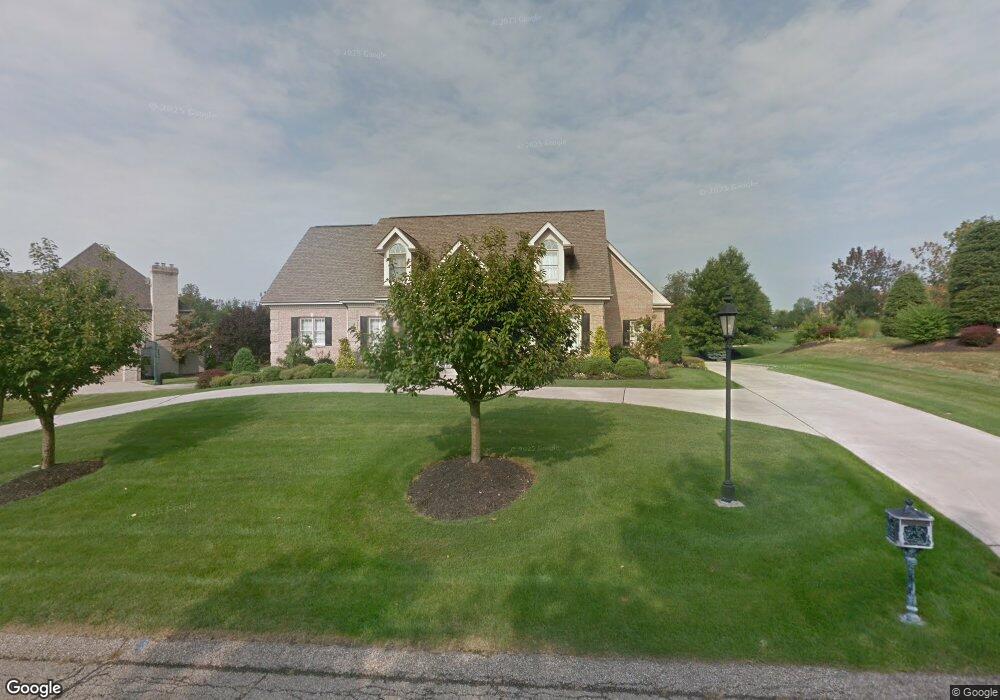
2010 Saint Andrews Dr Presto, PA 15142
Collier Township NeighborhoodEstimated Value: $751,994 - $932,000
4
Beds
4
Baths
3,084
Sq Ft
$267/Sq Ft
Est. Value
About This Home
This home is located at 2010 Saint Andrews Dr, Presto, PA 15142 and is currently estimated at $823,249, approximately $266 per square foot. 2010 Saint Andrews Dr is a home located in Allegheny County with nearby schools including Chartiers Valley Primary School, Chartiers Valley Intermediate School, and Chartiers Valley Middle School.
Ownership History
Date
Name
Owned For
Owner Type
Purchase Details
Closed on
Aug 10, 2000
Sold by
Deklewa Dave and Deklewa Carol L
Bought by
Maida Daniel E and Maida Mary P
Current Estimated Value
Purchase Details
Closed on
Apr 14, 2000
Sold by
John Deklewa & Sons Inc
Bought by
Malda Daniel E and Malda Mary P
Purchase Details
Closed on
Aug 9, 1988
Bought by
Bernard Larry E and Bernard Debra L
Create a Home Valuation Report for This Property
The Home Valuation Report is an in-depth analysis detailing your home's value as well as a comparison with similar homes in the area
Home Values in the Area
Average Home Value in this Area
Purchase History
| Date | Buyer | Sale Price | Title Company |
|---|---|---|---|
| Maida Daniel E | $524 | -- | |
| Malda Daniel E | $165,000 | -- | |
| Bernard Larry E | $103,000 | -- |
Source: Public Records
Tax History Compared to Growth
Tax History
| Year | Tax Paid | Tax Assessment Tax Assessment Total Assessment is a certain percentage of the fair market value that is determined by local assessors to be the total taxable value of land and additions on the property. | Land | Improvement |
|---|---|---|---|---|
| 2025 | $12,604 | $434,300 | $91,900 | $342,400 |
| 2024 | $12,604 | $434,300 | $91,900 | $342,400 |
| 2023 | $12,258 | $434,300 | $91,900 | $342,400 |
| 2022 | $11,981 | $434,300 | $91,900 | $342,400 |
| 2021 | $2,054 | $434,300 | $91,900 | $342,400 |
| 2020 | $11,461 | $434,300 | $91,900 | $342,400 |
| 2019 | $11,249 | $434,300 | $91,900 | $342,400 |
| 2018 | $2,054 | $434,300 | $91,900 | $342,400 |
| 2017 | $10,616 | $433,900 | $91,500 | $342,400 |
| 2016 | $2,052 | $433,900 | $91,500 | $342,400 |
| 2015 | $2,052 | $433,900 | $91,500 | $342,400 |
| 2014 | $10,275 | $433,900 | $91,500 | $342,400 |
Source: Public Records
Map
Nearby Homes
- 1095 Saint Mellion Dr
- 54 Price Rd
- 00 Price Rd
- 4020 Muirfield Dr
- 4040 Breckenridge Dr
- 755 Marigold Ct
- 2002 Black Bear Way
- 126 May Ave
- 212 Bridge St
- 1402 Commons Ln Unit 187
- 1405 Cambridge Dr
- 0 Rahner Wood Dr
- 1214 Washington Pike
- 247 May Ave
- 1098 Gromwell Ln
- 437 Montgomery Ave
- 285 Patterson Ave
- 215 Patterson Ave
- 371 Chess St
- 45 Dutch Hollow Rd
- 2020 Saint Andrews Dr
- 2000 Saint Andrews Dr
- 1130 Saint Mellion Dr
- 2025 Saint Andrews Dr
- 2015 Saint Andrews Dr
- 2030 Saint Andrews Dr
- 2035 Saint Andrews Dr
- 2005 Saint Andrews Dr
- 2045 Saint Andrews Dr
- 1105 Saint Mellion Dr
- 1140 Saint Mellion Dr
- 2055 Saint Andrews Dr
- 1115 Saint Mellion Dr
- 2050 Saint Andrews Dr
- 1120 Saint Mellion Dr
- 1150 Saint Mellion Dr
- 2065 Saint Andrews Dr
- 1125 Saint Mellion Dr
- lot 2 Salina Hawk Hill
- 2060 Saint Andrews Dr