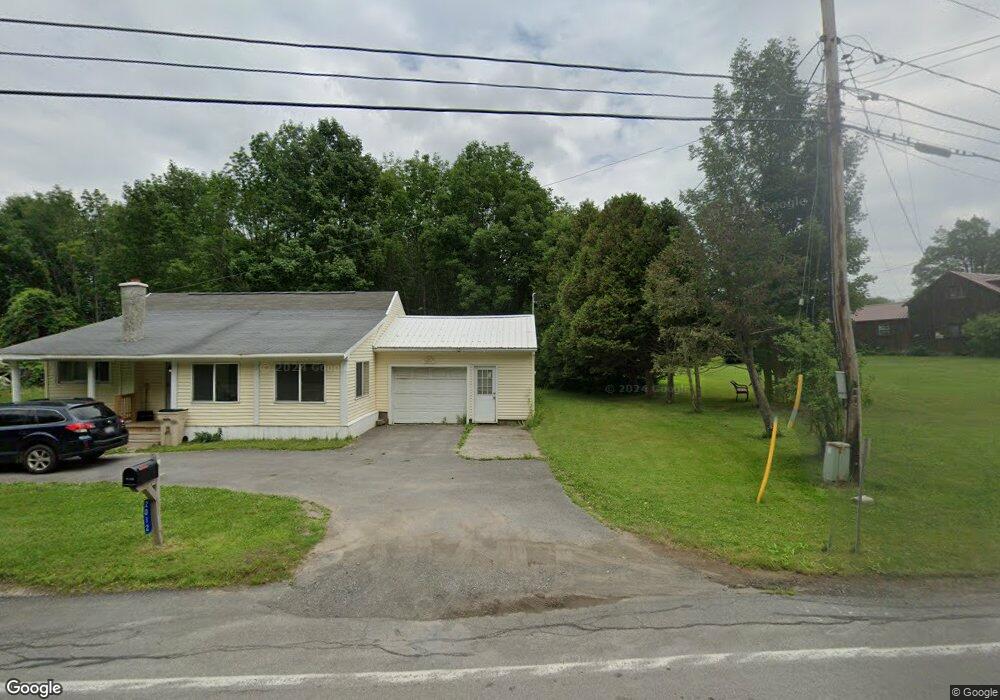
2010 State Route 28 Mohawk, NY 13407
Estimated Value: $244,980 - $592,000
2
Beds
1
Bath
1,431
Sq Ft
$289/Sq Ft
Est. Value
About This Home
This home is located at 2010 State Route 28, Mohawk, NY 13407 and is currently estimated at $413,995, approximately $289 per square foot. 2010 State Route 28 is a home located in Herkimer County with nearby schools including Harry M. Fisher Elementary School, Barringer Road Elementary School, and Gregory B. Jarvis Middle School.
Ownership History
Date
Name
Owned For
Owner Type
Purchase Details
Closed on
Aug 23, 2007
Sold by
Pilgrim William S
Bought by
Bullis William T
Current Estimated Value
Purchase Details
Closed on
Sep 13, 1996
Create a Home Valuation Report for This Property
The Home Valuation Report is an in-depth analysis detailing your home's value as well as a comparison with similar homes in the area
Home Values in the Area
Average Home Value in this Area
Purchase History
We collect this data history from publicly available records. To have your information removed, we recommend requesting removal directly through your county’s website.
| Date | Buyer | Sale Price | Title Company |
|---|---|---|---|
| Bullis William T | $138,000 | David M Primo | |
| -- | -- | -- |
Source: Public Records
Tax History
| Year | Tax Paid | Tax Assessment Tax Assessment Total Assessment is a certain percentage of the fair market value that is determined by local assessors to be the total taxable value of land and additions on the property. | Land | Improvement |
|---|---|---|---|---|
| 2025 | $1,522 | $118,200 | $42,700 | $75,500 |
| 2024 | $1,522 | $118,200 | $42,700 | $75,500 |
| 2023 | $1,412 | $118,200 | $42,700 | $75,500 |
| 2022 | $1,360 | $118,200 | $42,700 | $75,500 |
| 2021 | $1,352 | $118,200 | $42,700 | $75,500 |
| 2020 | $1,351 | $118,200 | $42,700 | $75,500 |
| 2019 | $1,319 | $118,200 | $42,700 | $75,500 |
| 2018 | $1,358 | $118,200 | $42,700 | $75,500 |
| 2017 | $1,337 | $118,200 | $42,700 | $75,500 |
| 2016 | $1,325 | $118,200 | $42,700 | $75,500 |
| 2015 | -- | $118,200 | $42,700 | $75,500 |
| 2014 | -- | $118,200 | $42,700 | $75,500 |
Source: Public Records
Map
Nearby Homes
- 2029 State Route 28
- 0 Polly Miller Rd Unit S1339037
- 172 Hinman Rd
- 389 Warren Rd
- 2361 Route 28
- 1194 Jordanville Rd
- 2607 State Route 28
- 104 Mortz Rd
- 847 Jordanville Rd
- 1451 Elizabethtown Rd
- 5 Columbia Cir
- 1189 Elizabethtown Rd
- 1214 Elizabethtown Rd
- 25 Henry St
- 420 Otsego St
- 13 Cary Ave
- L6 Jordanville Rd
- 21 Gordon Place
- 330 E Main St
- 989 Robinson Rd
- 2024 State Route 28
- 2018 State Route 28
- 2012 State Route 28
- 2004 State Route 28
- 2035 State Route 28
- 115 Horseshoe Ln
- 2040 State Route 28
- 2011 State Route 28
- 1979 State Highway 28
- 452 Eberline Rd
- 1986 State Route 28
- 1979 New York 28
- 108 Robinson Rd
- 1987 State Route 28
- 114 Robinson Rd
- 107 Robinson Rd
- 1973 State Route 28
- 1956 State Route 28
- 439 Eberline Rd
- 138 Robinson Rd
Your Personal Tour Guide
Ask me questions while you tour the home.