Estimated Value: $164,063 - $179,000
3
Beds
1
Bath
1,060
Sq Ft
$161/Sq Ft
Est. Value
About This Home
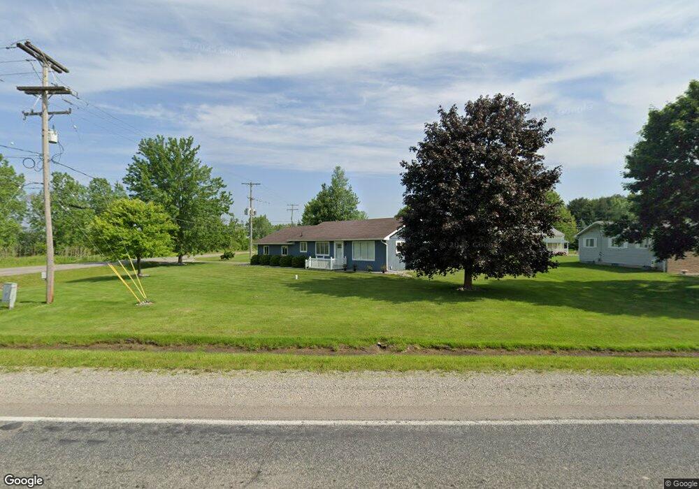
This home is located at 2011 E Dodge Rd, Clio, MI 48420 and is currently estimated at $170,266, approximately $160 per square foot. 2011 E Dodge Rd is a home located in Genesee County with nearby schools including Elisabeth Ann Johnson High School and St. Mary's School.
Ownership History
Date
Name
Owned For
Owner Type
Purchase Details
Closed on
Jan 3, 2023
Sold by
Perry Brenda G
Bought by
Perry Brenda F
Current Estimated Value
Home Financials for this Owner
Home Financials are based on the most recent Mortgage that was taken out on this home.
Original Mortgage
$58,000
Outstanding Balance
$45,505
Interest Rate
6.33%
Mortgage Type
Balloon
Estimated Equity
$124,761
Purchase Details
Closed on
Sep 30, 2012
Sold by
Perry William B
Bought by
Perry Brenda G
Purchase Details
Closed on
Dec 4, 2006
Sold by
Perry Brenda G
Bought by
Perry Brenda G and Perry William B
Home Financials for this Owner
Home Financials are based on the most recent Mortgage that was taken out on this home.
Original Mortgage
$46,000
Interest Rate
6.24%
Mortgage Type
New Conventional
Create a Home Valuation Report for This Property
The Home Valuation Report is an in-depth analysis detailing your home's value as well as a comparison with similar homes in the area
Home Values in the Area
Average Home Value in this Area
Purchase History
| Date | Buyer | Sale Price | Title Company |
|---|---|---|---|
| Perry Brenda F | -- | -- | |
| Perry Brenda G | -- | None Available | |
| Perry Brenda G | -- | Tristar |
Source: Public Records
Mortgage History
| Date | Status | Borrower | Loan Amount |
|---|---|---|---|
| Open | Perry Brenda F | $58,000 | |
| Previous Owner | Perry Brenda G | $46,000 |
Source: Public Records
Tax History
| Year | Tax Paid | Tax Assessment Tax Assessment Total Assessment is a certain percentage of the fair market value that is determined by local assessors to be the total taxable value of land and additions on the property. | Land | Improvement |
|---|---|---|---|---|
| 2025 | $1,318 | $68,500 | $0 | $0 |
| 2024 | $431 | $66,600 | $0 | $0 |
| 2023 | $411 | $60,900 | $0 | $0 |
| 2022 | $1,207 | $52,800 | $0 | $0 |
| 2021 | $1,864 | $47,300 | $0 | $0 |
| 2020 | $376 | $46,100 | $0 | $0 |
| 2019 | $370 | $41,000 | $0 | $0 |
| 2018 | $1,654 | $37,600 | $0 | $0 |
| 2017 | $1,601 | $38,200 | $0 | $0 |
| 2016 | $1,597 | $34,900 | $0 | $0 |
| 2015 | $1,366 | $32,900 | $0 | $0 |
| 2014 | $341 | $30,900 | $0 | $0 |
| 2012 | -- | $30,700 | $30,700 | $0 |
Source: Public Records
Map
Nearby Homes
- 1268 E Dodge Rd
- 9266 N Dort Hwy
- 10005 N Saginaw Rd
- 9307 N Bray Rd
- 1064 E Tobias Rd
- 1053 Wisner St
- 8261 N Dort Hwy
- V/L Washington Ave
- 766 Louisa St
- 1063 W Pine Ave
- 1408 W Wilson Rd
- 1095 Pine St
- 7 Clydesdale St
- 1421 E Mount Morris Rd
- 643 Roosevelt Ave
- 00 Roseberry Ln
- 1032 Maginn Ct
- 1122 Howard St
- 1515 W Frances Rd
- 12210 W Washington Ave
- 2027 E Dodge Rd
- 2037 E Dodge Rd
- 10036 N Lewis Rd
- 9520 N Lewis Rd
- 2043 E Dodge Rd
- 10048 N Lewis Rd
- 2053 E Dodge Rd
- 10062 N Lewis Rd
- 2060 E Dodge Rd
- 2071 E Dodge Rd
- 10070 N Lewis Rd
- 9484 N Lewis Rd
- 2080 E Dodge Rd
- 10086 N Lewis Rd
- 2081 E Dodge Rd
- 1367 E Dodge Rd
- 1367 E Dodge Rd
- 9450 N Lewis Rd
- 10098 N Lewis Rd
- 9468 N Lewis Rd
Your Personal Tour Guide
Ask me questions while you tour the home.