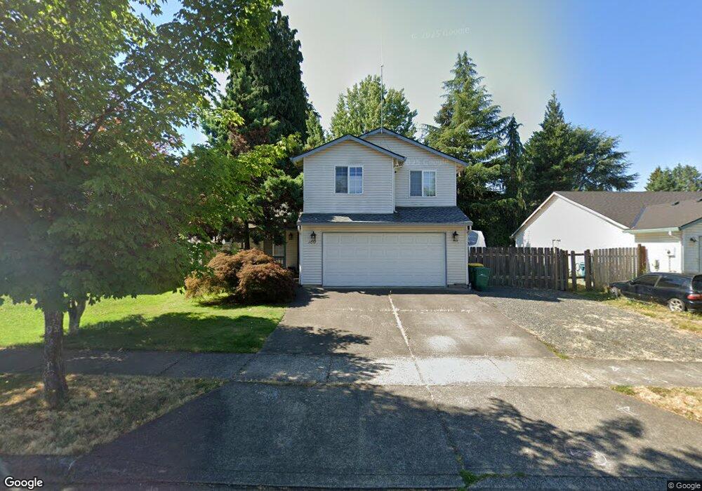
2012 30th Ave Forest Grove, OR 97116
Estimated Value: $421,000 - $493,000
4
Beds
3
Baths
1,359
Sq Ft
$332/Sq Ft
Est. Value
About This Home
This home is located at 2012 30th Ave, Forest Grove, OR 97116 and is currently estimated at $451,838, approximately $332 per square foot. 2012 30th Ave is a home located in Washington County with nearby schools including Harvey Clarke Elementary School, Tom McCall Upper Elementary School, and Neil Armstrong Middle School.
Ownership History
Date
Name
Owned For
Owner Type
Purchase Details
Closed on
Aug 5, 1997
Sold by
Quail Construction Inc
Bought by
Sager Hans C
Current Estimated Value
Home Financials for this Owner
Home Financials are based on the most recent Mortgage that was taken out on this home.
Original Mortgage
$127,301
Outstanding Balance
$17,575
Interest Rate
7.57%
Mortgage Type
FHA
Estimated Equity
$434,263
Purchase Details
Closed on
Aug 22, 1996
Sold by
Braukman Homes Inc
Bought by
Quall Construction Inc
Create a Home Valuation Report for This Property
The Home Valuation Report is an in-depth analysis detailing your home's value as well as a comparison with similar homes in the area
Purchase History
| Date | Buyer | Sale Price | Title Company |
|---|---|---|---|
| Sager Hans C | $128,399 | First American Title Ins Co | |
| Quall Construction Inc | $35,500 | Fidelity National Title Co |
Source: Public Records
Mortgage History
| Date | Status | Borrower | Loan Amount |
|---|---|---|---|
| Open | Sager Hans C | $127,301 |
Source: Public Records
Tax History
| Year | Tax Paid | Tax Assessment Tax Assessment Total Assessment is a certain percentage of the fair market value that is determined by local assessors to be the total taxable value of land and additions on the property. | Land | Improvement |
|---|---|---|---|---|
| 2026 | $4,224 | $237,210 | -- | -- |
| 2025 | $4,224 | $230,310 | -- | -- |
| 2024 | $4,075 | $223,610 | -- | -- |
| 2023 | $4,075 | $217,100 | $0 | $0 |
| 2022 | $3,563 | $217,100 | $0 | $0 |
| 2021 | $3,517 | $204,650 | $0 | $0 |
| 2020 | $3,498 | $198,690 | $0 | $0 |
| 2019 | $3,421 | $192,910 | $0 | $0 |
| 2018 | $3,316 | $187,300 | $0 | $0 |
| 2017 | $3,213 | $181,850 | $0 | $0 |
| 2016 | $3,123 | $176,560 | $0 | $0 |
| 2015 | $3,003 | $171,420 | $0 | $0 |
| 2014 | $2,988 | $166,430 | $0 | $0 |
Source: Public Records
Map
Nearby Homes
- 2106 Charlie Ct
- 2838 Charlie Ct
- 1926 27th Ave
- 2555 Bourbon St
- 2549 Bourbon St
- 2543 Bourbon St
- 2537 Bourbon St
- 2342 26th Ct
- 1636 Bonnie Ln
- 2032 Silverstone Dr
- 1960 Silverstone Dr
- 2081 Silverstone Dr
- 2443 26th Ave
- 2043 35th Ave
- 2091 35th Ave
- 2211 23rd Ave
- 1611 Camino Dr
- 1440 Alyssum Ave
- 2212 23rd Ave
- 2149 36th Unit Lot 59
Your Personal Tour Guide
Ask me questions while you tour the home.