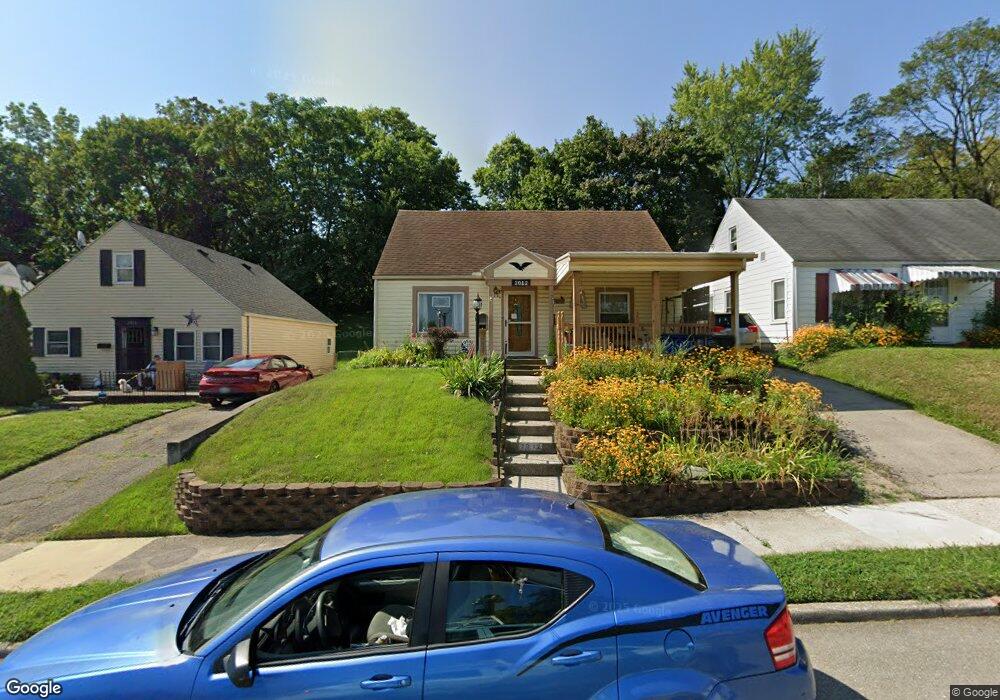
2012 Deanwood Ave Dayton, OH 45410
Linden Heights NeighborhoodEstimated Value: $130,000 - $175,000
3
Beds
1
Bath
1,339
Sq Ft
$108/Sq Ft
Est. Value
About This Home
This home is located at 2012 Deanwood Ave, Dayton, OH 45410 and is currently estimated at $144,008, approximately $107 per square foot. 2012 Deanwood Ave is a home located in Montgomery County with nearby schools including Cleveland Elementary School, Horace Mann Elementary School, and Eastmont Elementary.
Ownership History
Date
Name
Owned For
Owner Type
Purchase Details
Closed on
Jun 13, 2001
Sold by
Britton Anne E and Mckinley Anne E
Bought by
Mckinley Rick
Current Estimated Value
Home Financials for this Owner
Home Financials are based on the most recent Mortgage that was taken out on this home.
Original Mortgage
$35,025
Interest Rate
6.72%
Mortgage Type
Purchase Money Mortgage
Create a Home Valuation Report for This Property
The Home Valuation Report is an in-depth analysis detailing your home's value as well as a comparison with similar homes in the area
Home Values in the Area
Average Home Value in this Area
Purchase History
| Date | Buyer | Sale Price | Title Company |
|---|---|---|---|
| Mckinley Rick | -- | -- |
Source: Public Records
Mortgage History
| Date | Status | Borrower | Loan Amount |
|---|---|---|---|
| Closed | Mckinley Rick | $35,025 |
Source: Public Records
Tax History Compared to Growth
Tax History
| Year | Tax Paid | Tax Assessment Tax Assessment Total Assessment is a certain percentage of the fair market value that is determined by local assessors to be the total taxable value of land and additions on the property. | Land | Improvement |
|---|---|---|---|---|
| 2024 | $1,485 | $35,520 | $8,110 | $27,410 |
| 2023 | $1,485 | $35,520 | $8,110 | $27,410 |
| 2022 | $1,072 | $23,370 | $5,330 | $18,040 |
| 2021 | $1,066 | $23,370 | $5,330 | $18,040 |
| 2020 | $1,067 | $23,370 | $5,330 | $18,040 |
| 2019 | $838 | $18,870 | $3,810 | $15,060 |
| 2018 | $839 | $18,870 | $3,810 | $15,060 |
| 2017 | $833 | $18,870 | $3,810 | $15,060 |
| 2016 | $809 | $18,070 | $3,810 | $14,260 |
| 2015 | $766 | $18,070 | $3,810 | $14,260 |
| 2014 | $766 | $18,070 | $3,810 | $14,260 |
| 2012 | -- | $21,070 | $6,040 | $15,030 |
Source: Public Records
Map
Nearby Homes
- 2316 Wyoming St
- 853 Carlisle Ave
- 1105 Pursell Ave
- 1114 Arbor Ave
- 2010 Argyle Ave
- 2312 Saint Charles Ave
- 1230 Pursell Ave
- 722 Saint Nicholas Ave
- 630 Carlisle Ave
- 1254 Creighton Ave
- 1235 Holly Ave
- 626 Creighton Ave
- 621 Creighton Ave
- 1311 Pursell Ave
- 607 Carlisle Ave
- 1254 Phillips Ave
- 1741 King Ave
- 1255 Phillips Ave
- 1444 John Glenn Rd
- 631 Saint Nicholas Ave
- 2006 Deanwood Ave
- 2016 Deanwood Ave
- 2022 Deanwood Ave
- 2026 Deanwood Ave
- 852 Hodapp Ave
- 851 Wilfred Ave
- 2315 Wyoming St
- 2032 Deanwood Ave
- 2301 Wyoming St Unit C
- 2303 Wyoming St Unit E
- 848 Hodapp Ave
- 847 Wilfred Ave
- 2323 Wyoming St
- 1948 Deanwood Ave
- 844 Hodapp Ave
- 2329 Wyoming St
- 843 Wilfred Ave
- 851 Hodapp Ave
- 2215 Wyoming St
- 2036 Deanwood Ave