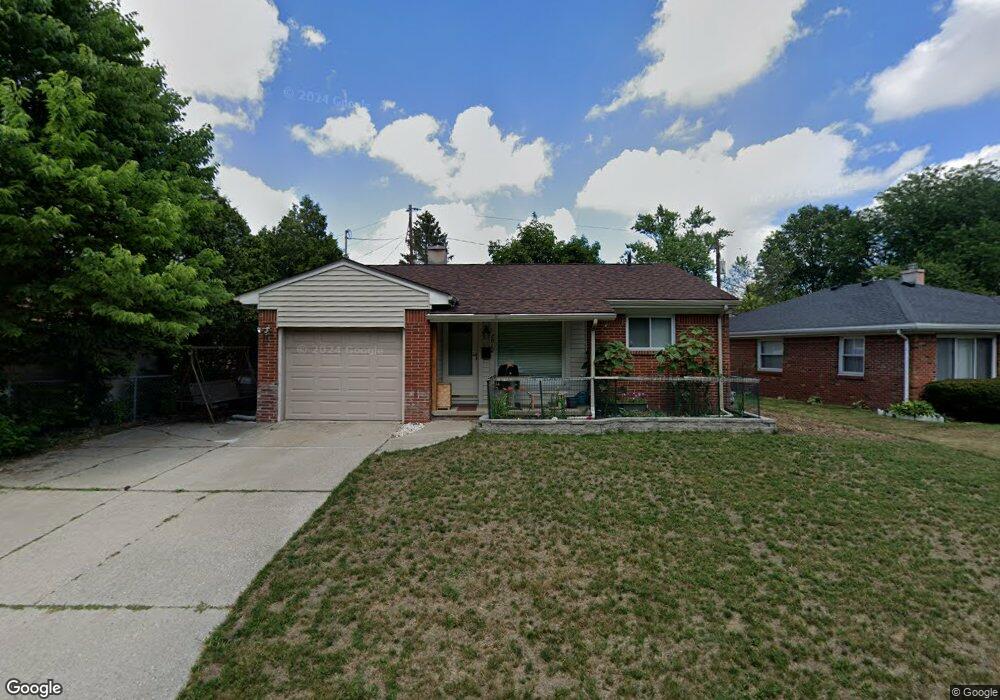
2012 Heatherdale Dr Toledo, OH 43609
Southside NeighborhoodEstimated Value: $78,000 - $89,000
2
Beds
1
Bath
996
Sq Ft
$82/Sq Ft
Est. Value
About This Home
This home is located at 2012 Heatherdale Dr, Toledo, OH 43609 and is currently estimated at $81,957, approximately $82 per square foot. 2012 Heatherdale Dr is a home located in Lucas County with nearby schools including Harvard Elementary School, Bowsher High School, and Explorers Academy of Science and Technology.
Ownership History
Date
Name
Owned For
Owner Type
Purchase Details
Closed on
Jul 1, 2020
Sold by
Zitzman Anthony M and Zitzman Monica A
Bought by
Juikrathok Phatsawat
Current Estimated Value
Purchase Details
Closed on
Oct 13, 1998
Sold by
Hoepf Cindy A and Kessler Cindy A
Bought by
Zitzman Anthony M and Zitzman Monica A
Home Financials for this Owner
Home Financials are based on the most recent Mortgage that was taken out on this home.
Original Mortgage
$55,056
Interest Rate
6.9%
Mortgage Type
FHA
Purchase Details
Closed on
Feb 20, 1990
Sold by
Anderson W Gregg
Create a Home Valuation Report for This Property
The Home Valuation Report is an in-depth analysis detailing your home's value as well as a comparison with similar homes in the area
Home Values in the Area
Average Home Value in this Area
Purchase History
| Date | Buyer | Sale Price | Title Company |
|---|---|---|---|
| Juikrathok Phatsawat | $50,000 | Greater Metropolitan Title | |
| Zitzman Anthony M | $55,000 | -- | |
| -- | $47,000 | -- |
Source: Public Records
Mortgage History
| Date | Status | Borrower | Loan Amount |
|---|---|---|---|
| Previous Owner | Zitzman Anthony M | $55,056 |
Source: Public Records
Tax History Compared to Growth
Tax History
| Year | Tax Paid | Tax Assessment Tax Assessment Total Assessment is a certain percentage of the fair market value that is determined by local assessors to be the total taxable value of land and additions on the property. | Land | Improvement |
|---|---|---|---|---|
| 2024 | $701 | $20,160 | $5,565 | $14,595 |
| 2023 | $1,408 | $19,565 | $3,850 | $15,715 |
| 2022 | $1,389 | $19,565 | $3,850 | $15,715 |
| 2021 | $1,438 | $19,565 | $3,850 | $15,715 |
| 2020 | $1,414 | $16,520 | $3,220 | $13,300 |
| 2019 | $1,357 | $16,520 | $3,220 | $13,300 |
| 2018 | $1,387 | $16,520 | $3,220 | $13,300 |
| 2017 | $1,361 | $16,135 | $3,150 | $12,985 |
| 2016 | $1,383 | $46,100 | $9,000 | $37,100 |
| 2015 | $1,407 | $46,100 | $9,000 | $37,100 |
| 2014 | $1,015 | $16,140 | $3,150 | $12,990 |
| 2013 | $1,015 | $16,140 | $3,150 | $12,990 |
Source: Public Records
Map
Nearby Homes
- 531 Shasta Dr
- 705 Wright Ave
- 649 Wright Ave
- 870 National Ave
- 518 Myers St
- 885 National Ave
- 859 Wright Ave
- 440 Somerset St
- 512 Woodsdale Ave
- 1777 South Ave
- 2126 Airport Hwy
- 713 Geneva Ave
- 940 Francis Ave
- 731 Geneva Ave
- 819 Geneva Ave
- 909 Woodsdale Ave
- 1011 National Ave
- 804 Hampton Ave
- 321 Mayberry St
- 1455 & 1457 Ingomar Ave
- 2004 Heatherdale Dr
- 1951 Glencove Dr
- 2007 Glencove Dr
- 1946 Heatherdale Dr
- 1945 Glencove Dr
- 1942 Heatherdale Dr
- 1941 Glencove Dr
- 1937 Glencove Dr
- 1936 Heatherdale Dr
- 1932 Heatherdale Dr
- 2004 Glencove Dr
- 1931 Glencove Dr
- 2012 Glencove Dr
- 1946 Glencove Dr
- 1928 Heatherdale Dr
- 2018 Glencove Dr
- 1927 Glencove Dr
- 1938 Glencove Dr
- 2022 Glencove Dr