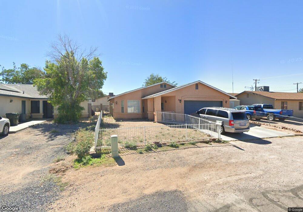
2012 Pacific Ave Kingman, AZ 86401
Estimated Value: $228,000 - $237,302
3
Beds
2
Baths
1,477
Sq Ft
$157/Sq Ft
Est. Value
About This Home
This home is located at 2012 Pacific Ave, Kingman, AZ 86401 and is currently estimated at $231,826, approximately $156 per square foot. 2012 Pacific Ave is a home located in Mohave County with nearby schools including Manzanita Elementary School, Kingman Middle School, and Kingman High School.
Ownership History
Date
Name
Owned For
Owner Type
Purchase Details
Closed on
Mar 20, 2018
Sold by
Taflan Mike and Taflan Wendi
Bought by
Taflan Mircea Dan Mike and Taflan Wendi
Current Estimated Value
Purchase Details
Closed on
Sep 13, 2011
Sold by
Perry Ronald and Perry Melissa
Bought by
Taflan Mike and Taflan Wendi
Purchase Details
Closed on
Jul 5, 2005
Sold by
Flatt Clifford and Flatt Christine
Bought by
Perry Ronald and Perry Melissa
Home Financials for this Owner
Home Financials are based on the most recent Mortgage that was taken out on this home.
Original Mortgage
$129,500
Interest Rate
5.66%
Mortgage Type
New Conventional
Create a Home Valuation Report for This Property
The Home Valuation Report is an in-depth analysis detailing your home's value as well as a comparison with similar homes in the area
Home Values in the Area
Average Home Value in this Area
Purchase History
| Date | Buyer | Sale Price | Title Company |
|---|---|---|---|
| Taflan Mircea Dan Mike | -- | None Available | |
| Taflan Mike | $48,900 | Pioneer Title Agency Inc | |
| Perry Ronald | $185,000 | Transnation Title |
Source: Public Records
Mortgage History
| Date | Status | Borrower | Loan Amount |
|---|---|---|---|
| Previous Owner | Perry Ronald | $129,500 |
Source: Public Records
Tax History
| Year | Tax Paid | Tax Assessment Tax Assessment Total Assessment is a certain percentage of the fair market value that is determined by local assessors to be the total taxable value of land and additions on the property. | Land | Improvement |
|---|---|---|---|---|
| 2026 | -- | -- | -- | -- |
| 2025 | $897 | $20,734 | $0 | $0 |
| 2024 | $897 | $22,415 | $0 | $0 |
| 2023 | $897 | $17,733 | $0 | $0 |
| 2022 | $832 | $14,490 | $0 | $0 |
| 2021 | $862 | $12,975 | $0 | $0 |
| 2019 | $787 | $11,904 | $0 | $0 |
| 2018 | $813 | $11,214 | $0 | $0 |
| 2017 | $748 | $10,059 | $0 | $0 |
| 2016 | $722 | $9,507 | $0 | $0 |
| 2015 | $737 | $8,114 | $0 | $0 |
Source: Public Records
Map
Nearby Homes
- 1974 Miami Ave
- 2803 Fairgrounds Blvd
- 1943 Hope Ave
- 2027 Motor Ave
- 1955 Motor Ave
- 2036 Davis Ave
- 1953 Club Ave
- 1959 Golden Gate Ave
- 1825 Atlantic Ave
- 2209 Los Angeles St
- 1810 Airfield Ave
- 2106 Fairgrounds Blvd
- 2708 Mullen Dr
- 1820 Motor Ave
- 1816 Motor Ave
- 1732 Miami Ave
- 2918 Arthur St
- 1744 Motor Ave
- 2414 Ricca Dr
- 2410 Airfield Ave
- 2014 Pacific Ave
- 2810 Main St
- 2814 Main St
- 2011 Atlantic Ave
- 2020 Pacific Ave
- 2001 Atlantic Ave
- 2017 Atlantic Ave
- 2022 Pacific Ave
- 2011 Pacific Ave
- 2015 Pacific Ave
- 2001 Pacific Ave
- 2019 Atlantic Ave
- 1978 Pacific Ave
- 2025 Atlantic Ave
- 2716 Main St
- 1973 Atlantic Ave
- 2030 Pacific Ave
- 2027 Pacific Ave
- 2012 Atlantic Ave
- 2012 Miami Ave
Your Personal Tour Guide
Ask me questions while you tour the home.