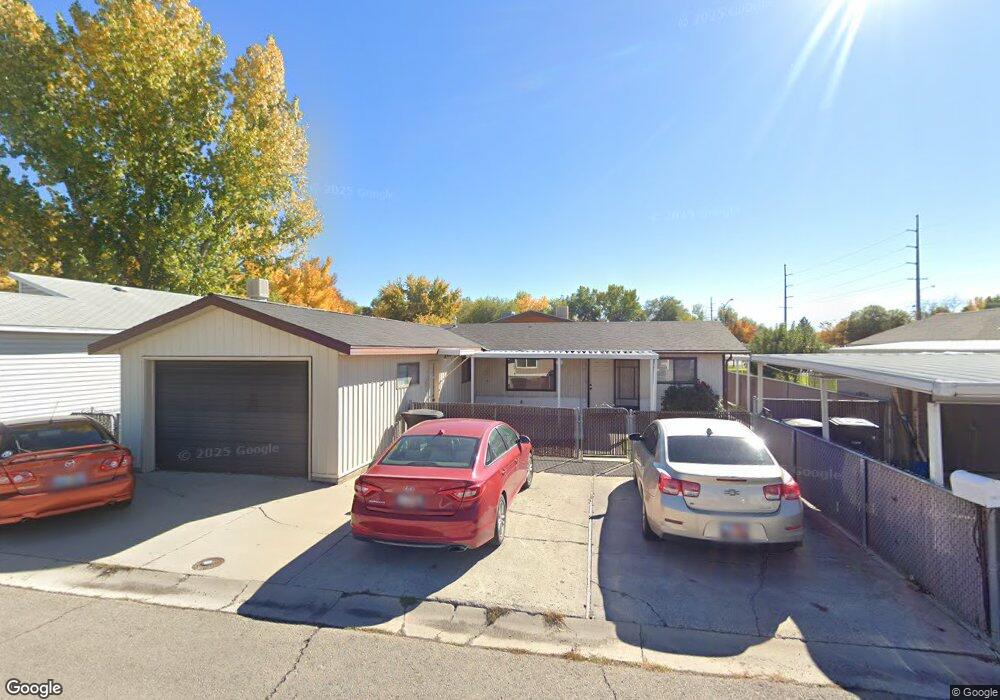
2012 W 450 N Provo, UT 84601
Lakeview NeighborhoodEstimated Value: $361,077 - $408,000
2
Beds
1
Bath
1,152
Sq Ft
$327/Sq Ft
Est. Value
About This Home
This home is located at 2012 W 450 N, Provo, UT 84601 and is currently estimated at $376,769, approximately $327 per square foot. 2012 W 450 N is a home located in Utah County with nearby schools including Dixon Middle School, Provo High School, and Freedom Preparatory Academy.
Ownership History
Date
Name
Owned For
Owner Type
Purchase Details
Closed on
Nov 14, 2019
Sold by
Kinder Cheltsey S
Bought by
Olsen Amanda and Barnett Cody
Current Estimated Value
Home Financials for this Owner
Home Financials are based on the most recent Mortgage that was taken out on this home.
Original Mortgage
$204,232
Outstanding Balance
$180,205
Interest Rate
3.75%
Mortgage Type
FHA
Estimated Equity
$196,564
Purchase Details
Closed on
Jan 27, 2017
Sold by
Jensen Clifton Edmund and Jensen Clifton Edmund
Bought by
Kinder Cheltsey S
Home Financials for this Owner
Home Financials are based on the most recent Mortgage that was taken out on this home.
Original Mortgage
$137,464
Interest Rate
4.16%
Mortgage Type
FHA
Purchase Details
Closed on
Nov 5, 2010
Sold by
Jensen Clifton E
Bought by
Jensen Clifton Edmund and Jensen Clifton Edmund
Create a Home Valuation Report for This Property
The Home Valuation Report is an in-depth analysis detailing your home's value as well as a comparison with similar homes in the area
Home Values in the Area
Average Home Value in this Area
Purchase History
| Date | Buyer | Sale Price | Title Company |
|---|---|---|---|
| Olsen Amanda | -- | Integrated Title Ins Svcs | |
| Kinder Cheltsey S | -- | Inwest Title | |
| Jensen Clifton Edmund | -- | Accommodation |
Source: Public Records
Mortgage History
| Date | Status | Borrower | Loan Amount |
|---|---|---|---|
| Open | Olsen Amanda | $204,232 | |
| Previous Owner | Kinder Cheltsey S | $137,464 |
Source: Public Records
Tax History Compared to Growth
Tax History
| Year | Tax Paid | Tax Assessment Tax Assessment Total Assessment is a certain percentage of the fair market value that is determined by local assessors to be the total taxable value of land and additions on the property. | Land | Improvement |
|---|---|---|---|---|
| 2025 | $1,215 | $137,060 | $87,800 | $161,400 |
| 2024 | $1,215 | $119,570 | $0 | $0 |
| 2023 | $1,155 | $112,035 | $0 | $0 |
| 2022 | $1,119 | $109,450 | $0 | $0 |
| 2021 | $865 | $147,600 | $49,500 | $98,100 |
| 2020 | $839 | $134,200 | $45,000 | $89,200 |
| 2019 | $737 | $122,600 | $45,000 | $77,600 |
Source: Public Records
Map
Nearby Homes
- 392 N 2150 W
- 201 N Geneva Rd Unit 3
- 255 N 1600 W Unit 148
- 255 N 1600 W Unit 52
- 255 N 1600 W Unit 84
- 255 N 1600 W Unit 108
- 2216 W 480 N
- 1744 W 150 N
- 398 N 2380 W
- 582 N 2310 W
- 227 West Ln
- 1828 W 170 S
- 927 Independence Ave
- 154 N 2560 W
- 1375 W 500 N Unit 95
- 147 S 1680 W
- 962 Independence Ave
- 273 S 1860 W
- 932 N 1760 W
- 312 S 1920 W
- 2002 W 450 N
- 2022 W 450 N
- 1982 W 450 N Unit 82
- 1997 W 450 N
- 435 N 2025 W Unit 5
- 410 N 2050 W
- 445 N 2025 W
- 410 N Geneva Rd
- 2004 W 550 St N Unit 50
- 1972 W 450 N Unit 83
- 1984 W 550 St N
- 475 N 2025 W
- 2015 W 350 N
- 2019 W 350 N
- 1974 W 550 St N
- 1967 W 450 N
- 427 N Geneva Rd
- 1995 W 350 St N
- 409 N Geneva Rd
- 399 N Geneva Rd