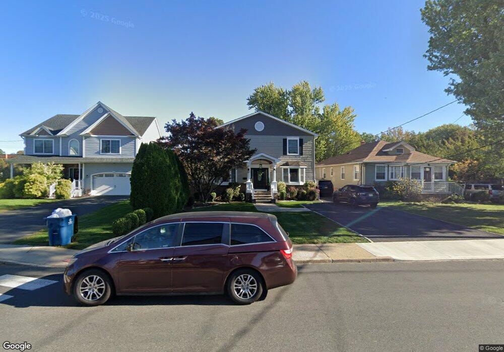
2012 Westfield Ave Scotch Plains, NJ 07076
Estimated Value: $728,557 - $1,137,000
--
Bed
--
Bath
3,150
Sq Ft
$303/Sq Ft
Est. Value
About This Home
This home is located at 2012 Westfield Ave, Scotch Plains, NJ 07076 and is currently estimated at $955,889, approximately $303 per square foot. 2012 Westfield Ave is a home located in Union County with nearby schools including Evergreen Elementary School, Nettingham Middle School, and Scotch Plains-Fanwood High School.
Ownership History
Date
Name
Owned For
Owner Type
Purchase Details
Closed on
Aug 15, 2005
Sold by
Kinsella Dennis R
Bought by
Larosa Anthony
Current Estimated Value
Home Financials for this Owner
Home Financials are based on the most recent Mortgage that was taken out on this home.
Original Mortgage
$296,000
Interest Rate
6.06%
Mortgage Type
New Conventional
Purchase Details
Closed on
Jun 19, 2001
Sold by
Williams Steven L and Williams Mary Rita
Bought by
Kinsella Dennis R
Home Financials for this Owner
Home Financials are based on the most recent Mortgage that was taken out on this home.
Original Mortgage
$163,212
Interest Rate
7.09%
Mortgage Type
FHA
Purchase Details
Closed on
May 26, 1995
Sold by
Martin James S and Honan Jean Adele
Bought by
Williams Steven L and Williams Mary Rita
Purchase Details
Closed on
Mar 24, 1995
Sold by
Martin James S and Honan Jean Adele
Bought by
Martin James S and Honan Jean Adele
Create a Home Valuation Report for This Property
The Home Valuation Report is an in-depth analysis detailing your home's value as well as a comparison with similar homes in the area
Home Values in the Area
Average Home Value in this Area
Purchase History
| Date | Buyer | Sale Price | Title Company |
|---|---|---|---|
| Larosa Anthony | $370,000 | -- | |
| Kinsella Dennis R | $189,000 | -- | |
| Williams Steven L | $112,500 | -- | |
| Martin James S | -- | -- |
Source: Public Records
Mortgage History
| Date | Status | Borrower | Loan Amount |
|---|---|---|---|
| Previous Owner | Larosa Anthony | $296,000 | |
| Previous Owner | Kinsella Dennis R | $163,212 |
Source: Public Records
Tax History Compared to Growth
Tax History
| Year | Tax Paid | Tax Assessment Tax Assessment Total Assessment is a certain percentage of the fair market value that is determined by local assessors to be the total taxable value of land and additions on the property. | Land | Improvement |
|---|---|---|---|---|
| 2025 | $16,405 | $139,400 | $30,900 | $108,500 |
| 2024 | $15,921 | $139,400 | $30,900 | $108,500 |
| 2023 | $15,921 | $139,400 | $30,900 | $108,500 |
| 2022 | $15,235 | $135,000 | $30,900 | $104,100 |
| 2021 | $15,209 | $135,000 | $30,900 | $104,100 |
| 2020 | $15,136 | $135,000 | $30,900 | $104,100 |
| 2019 | $15,024 | $135,000 | $30,900 | $104,100 |
| 2018 | $14,772 | $135,000 | $30,900 | $104,100 |
| 2017 | $14,444 | $135,000 | $30,900 | $104,100 |
| 2016 | $14,166 | $135,000 | $30,900 | $104,100 |
| 2015 | $13,933 | $135,000 | $30,900 | $104,100 |
| 2014 | $13,474 | $135,000 | $30,900 | $104,100 |
Source: Public Records
Map
Nearby Homes
- 360 Cook Ave
- 545 Westfield Rd
- 177 Pleasant Ave
- 2060 Mountain Ave
- 2085 Nicholl Ave
- 24 Deborah Way
- 2227 Pine Terrace
- 230 Pinehurst Ave
- 2323 Belvedere Dr
- 121 Donato Cir
- 352 Myrtle Ave
- 215 Katherine St
- 802 Donato Cir Unit A1
- 709 Donato Cir
- 4 Lois Place
- 2269 Redwood Rd
- 524 William St
- 183 Watson Rd
- 9 Timberline Dr
- 1370 Johnston Dr
- 2008 Westfield Ave
- 2016 Westfield Ave
- 2004 Westfield Ave
- 2007 Westfield Ave
- 2007 Westfield Ave Unit B
- 2015 Westfield Ave
- 1998 Westfield Ave
- 2027 Westfield Ave
- 2005 Westfield Ave
- 427 Montague Ave
- 1997 Westfield Ave
- 1992 Westfield Ave
- 425 Montague Ave
- 423 Montague Ave
- 422 Montague Ave
- 2033 Westfield Ave
- 1988 Westfield Ave
- 2038 Westfield Ave
- 2005 Birch St
- 427 Stout Ave