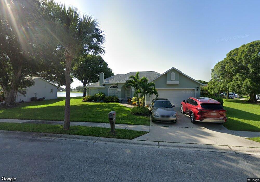
2013 Adirondack Cir Melbourne, FL 32935
Estimated Value: $368,000 - $429,000
3
Beds
2
Baths
1,587
Sq Ft
$252/Sq Ft
Est. Value
About This Home
This home is located at 2013 Adirondack Cir, Melbourne, FL 32935 and is currently estimated at $400,493, approximately $252 per square foot. 2013 Adirondack Cir is a home located in Brevard County with nearby schools including Croton Elementary School, Lyndon B. Johnson Middle School, and Eau Gallie High School.
Ownership History
Date
Name
Owned For
Owner Type
Purchase Details
Closed on
Jun 24, 1997
Sold by
Hill Darrell E
Bought by
Hill Darrell E and Hill Nancy C
Current Estimated Value
Purchase Details
Closed on
Dec 8, 1993
Sold by
Mercedes Homes Inc
Bought by
Hill Darrell E
Home Financials for this Owner
Home Financials are based on the most recent Mortgage that was taken out on this home.
Original Mortgage
$99,100
Interest Rate
6.85%
Create a Home Valuation Report for This Property
The Home Valuation Report is an in-depth analysis detailing your home's value as well as a comparison with similar homes in the area
Home Values in the Area
Average Home Value in this Area
Purchase History
| Date | Buyer | Sale Price | Title Company |
|---|---|---|---|
| Hill Darrell E | $22,500 | -- | |
| Hill Darrell E | $104,600 | -- |
Source: Public Records
Mortgage History
| Date | Status | Borrower | Loan Amount |
|---|---|---|---|
| Previous Owner | Hill Darrell E | $99,100 |
Source: Public Records
Tax History
| Year | Tax Paid | Tax Assessment Tax Assessment Total Assessment is a certain percentage of the fair market value that is determined by local assessors to be the total taxable value of land and additions on the property. | Land | Improvement |
|---|---|---|---|---|
| 2025 | $2,356 | $175,890 | -- | -- |
| 2024 | $2,294 | $170,940 | -- | -- |
| 2023 | $2,294 | $165,970 | $0 | $0 |
| 2022 | $2,145 | $161,140 | $0 | $0 |
| 2021 | $1,278 | $107,210 | $0 | $0 |
| 2020 | $1,259 | $105,730 | $0 | $0 |
| 2019 | $1,257 | $103,360 | $0 | $0 |
| 2018 | $1,247 | $101,440 | $0 | $0 |
| 2017 | $1,240 | $99,360 | $0 | $0 |
| 2016 | $1,262 | $97,320 | $35,000 | $62,320 |
| 2015 | $1,285 | $96,650 | $28,000 | $68,650 |
| 2014 | $1,264 | $95,890 | $28,000 | $67,890 |
Source: Public Records
Map
Nearby Homes
- 2015 Blue Ridge Ave
- 2021 Buescher Hill St
- 2322 Appalachian Dr
- 2322 Royal Poinciana Blvd
- 2219 Flower Tree Cir
- 0000 Unknown Rd
- 2182 Appalachian Dr
- 1940 Dawn Dr
- 2309 Myla Ln
- 124 Squire Dr
- 1941 Dawn Dr
- 0001 Aurora Rd
- 2315 Early Dawn Cir
- 168 Ulster Ct
- 1855 Dawn Dr
- 247 Cambridge Ln Unit 247
- 174 Ulster Ln
- 111 Bristol Ln Unit 111
- 207 Bristol Ln Unit 207
- 125 Bristol Ln
- 2009 Adirondack Cir
- 2017 Adirondack Cir
- 2012 Adirondack Cir
- 2021 Adirondack Cir
- 2016 Adirondack Cir
- 2005 Adirondack Cir
- 2010 Adirondack Cir
- 2020 Adirondack Cir
- 2004 Adirondack Cir
- 2025 Adirondack Cir
- 2001 Adirondack Cir
- 2019 Blue Ridge Ave
- 2023 Blue Ridge Ave
- 2024 Adirondack Cir
- 2000 Adirondack Cir
- 2027 Blue Ridge Ave
- 2029 Adirondack Cir
- 2011 Blue Ridge Ave
- 2031 Blue Ridge Ave
- 2028 Adirondack Cir