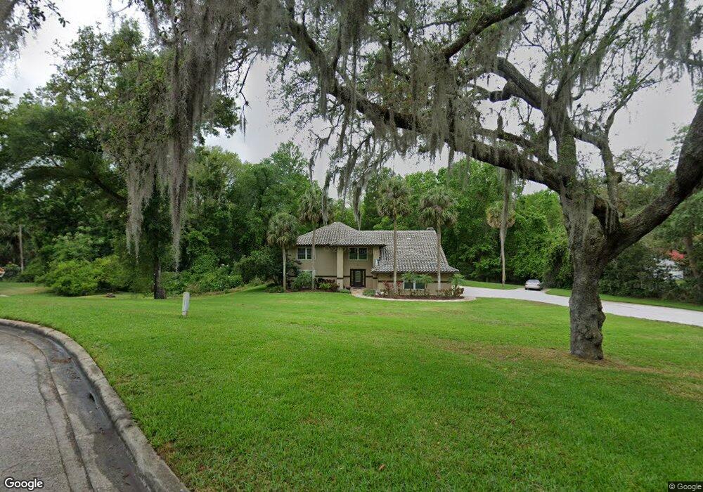
2013 Vanderbilt Point Longwood, FL 32779
Estimated Value: $823,000 - $982,000
4
Beds
4
Baths
4,068
Sq Ft
$219/Sq Ft
Est. Value
About This Home
This home is located at 2013 Vanderbilt Point, Longwood, FL 32779 and is currently estimated at $889,934, approximately $218 per square foot. 2013 Vanderbilt Point is a home located in Seminole County with nearby schools including Woodlands Elementary School, Lyman High School, and Rock Lake Middle School.
Ownership History
Date
Name
Owned For
Owner Type
Purchase Details
Closed on
Oct 29, 2009
Sold by
Gibraltar Real Estate & Investments Inc
Bought by
Falso John and Falso Tonya
Current Estimated Value
Purchase Details
Closed on
Aug 1, 2009
Bought by
Falso John and Falso Tonya
Purchase Details
Closed on
Dec 22, 2008
Sold by
2013 Vanderbilt Pt Trust
Bought by
Williams Magdalene
Purchase Details
Closed on
Dec 1, 2008
Bought by
Falso John and Falso Tonya
Purchase Details
Closed on
Aug 10, 2007
Sold by
Williams Magdalene
Bought by
Trus 2013 Vanderbilt Point and Trust #2013 Vanderbilt Point
Purchase Details
Closed on
Aug 1, 2007
Bought by
Falso John and Falso Tonya
Purchase Details
Closed on
May 26, 2006
Sold by
Gleaton Kimberly
Bought by
Williams Magdalene
Home Financials for this Owner
Home Financials are based on the most recent Mortgage that was taken out on this home.
Original Mortgage
$618,400
Interest Rate
8.75%
Mortgage Type
Fannie Mae Freddie Mac
Purchase Details
Closed on
Jan 19, 2006
Sold by
Cowan David S and Cowan Carol A
Bought by
Gleaton Kimberly
Home Financials for this Owner
Home Financials are based on the most recent Mortgage that was taken out on this home.
Original Mortgage
$669,900
Interest Rate
6.21%
Mortgage Type
Balloon
Purchase Details
Closed on
Jun 6, 1997
Sold by
Guarante Gerard W and Boyd Gae W
Bought by
Cowan David S and Cowan Carol A
Home Financials for this Owner
Home Financials are based on the most recent Mortgage that was taken out on this home.
Original Mortgage
$175,000
Interest Rate
8.13%
Mortgage Type
New Conventional
Purchase Details
Closed on
Jun 24, 1994
Sold by
Fletcher Marty D and Fletcher Julie W
Bought by
Massie Joseph
Home Financials for this Owner
Home Financials are based on the most recent Mortgage that was taken out on this home.
Original Mortgage
$119,000
Interest Rate
8.51%
Purchase Details
Closed on
Jan 1, 1989
Bought by
Falso John and Falso Tonya
Purchase Details
Closed on
Sep 1, 1988
Bought by
Falso John and Falso Tonya
Purchase Details
Closed on
Aug 1, 1985
Bought by
Falso John and Falso Tonya
Create a Home Valuation Report for This Property
The Home Valuation Report is an in-depth analysis detailing your home's value as well as a comparison with similar homes in the area
Home Values in the Area
Average Home Value in this Area
Purchase History
| Date | Buyer | Sale Price | Title Company |
|---|---|---|---|
| Falso John | $319,000 | Westcor Land Title Insurance | |
| Falso John | $100 | -- | |
| Williams Magdalene | -- | None Available | |
| Falso John | $100 | -- | |
| Trus 2013 Vanderbilt Point | -- | None Available | |
| Falso John | $100 | -- | |
| Williams Magdalene | $773,000 | Security Trust Title Llc | |
| Gleaton Kimberly | $669,900 | First Southwestern Title Com | |
| Cowan David S | $265,000 | -- | |
| Massie Joseph | $219,000 | -- | |
| Falso John | $240,000 | -- | |
| Falso John | $1,000 | -- | |
| Falso John | $225,000 | -- |
Source: Public Records
Mortgage History
| Date | Status | Borrower | Loan Amount |
|---|---|---|---|
| Previous Owner | Williams Magdalene | $618,400 | |
| Previous Owner | Gleaton Kimberly | $669,900 | |
| Previous Owner | Cowan David S | $250,000 | |
| Previous Owner | Cowan David S | $175,000 | |
| Previous Owner | Massie Joseph | $119,000 |
Source: Public Records
Tax History Compared to Growth
Tax History
| Year | Tax Paid | Tax Assessment Tax Assessment Total Assessment is a certain percentage of the fair market value that is determined by local assessors to be the total taxable value of land and additions on the property. | Land | Improvement |
|---|---|---|---|---|
| 2024 | $5,323 | $398,309 | -- | -- |
| 2023 | $5,205 | $386,708 | $0 | $0 |
| 2021 | $5,009 | $364,510 | $0 | $0 |
| 2020 | $4,969 | $359,477 | $0 | $0 |
| 2019 | $4,926 | $351,395 | $0 | $0 |
| 2018 | $4,880 | $344,843 | $0 | $0 |
| 2017 | $4,858 | $337,750 | $0 | $0 |
| 2016 | $4,951 | $333,119 | $0 | $0 |
| 2015 | $5,004 | $328,503 | $0 | $0 |
| 2014 | $4,482 | $325,896 | $0 | $0 |
Source: Public Records
Map
Nearby Homes
- 144 Springwood Cir Unit F
- 127 Springwood Cir Unit A
- 152 Springwood Cir Unit B
- 156 Springwood Cir Unit C
- 113 Springwood Cir Unit 113D
- 204 Brom Bones Ln
- 120 Lake Oaks Blvd
- 394 Woodstead Cir
- 310 Wild Olive Ln
- 111 Tarrytown Trail
- 113 Tarrytown Trail
- 113 Weeping Elm Ln
- 116 Wild Holly Ln
- 2142 Woodbridge Rd
- 264 Agnes Ave
- 1415 W Marvin St
- 1919 Lost Spring Ct
- 104 Wild Plum Ln
- 220 Pine Cone Ln
- 128 Woodmill Rd
- 2007 Vanderbilt Point
- 2019 Vanderbilt Point
- 2025 Vanderbilt Point
- 2001 Vanderbilt Point
- 330 Markham Woods Rd
- 340 Markham Woods Rd
- 256 Markham Woods Rd
- 264 Markham Woods Rd
- 252 Markham Woods Rd
- 477 Pickford Point
- 260 Markham Woods Rd
- 315 Starbuck Run
- 350 Markham Woods Rd
- 248 Markham Woods Rd
- 483 Pickford Point
- 244 Markham Woods Rd
- 482 Pickford Point
- 340 Starbuck Run
- 335 Starbuck Run
- 484 Villa Nova Point