
20139 Bowman Rd Spring Hill, FL 34610
Estimated payment $80,432/month
Highlights
- 119 Acre Lot
- No HOA
- Level Lot
About This Lot
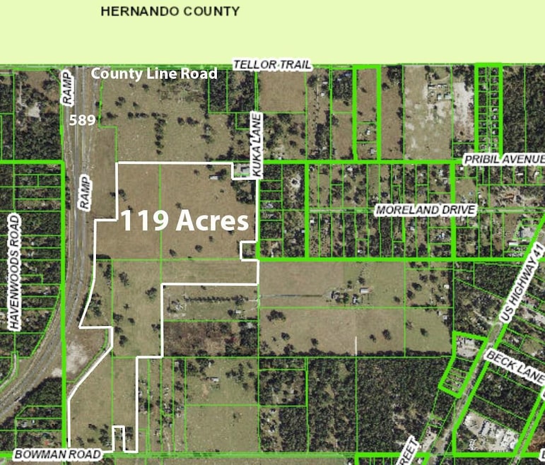
119 ACRES FOR FUTURE DEVELOPMENT SITE - located on the east side of the Suncoast Parkway (589) just south of County Line Road. Property is in PASCO'S FUTURE LAND USE for EC. Many positives about this property for a developer:
NO FLOOD (X ZONE).
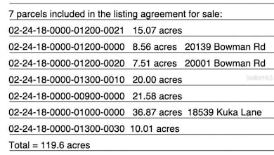
NO WETLANDS. ALREADY CLEARED. PROPERTY IS LEVEL. Located in a DESIGNATED OPPORTUNITY ZONE (The Tax Cuts and Jobs Act of 2017 established Opportunity Zones as a mechanism to provide tax incentives for investment in designated census tracts. Investments made by individuals through special funds in these zones would be allowed to defer or eliminate federal taxes on capital gains). Property is in PASCO'S FUTURE LAND USE for EC - High density residential. The EC land use designation is a mixed use land use category that permits Corporate Business Parks, “Targeted Primary Businesses”, higher density residential, and industrial uses. There are not many sites with this much acreage available next to the Suncoast parkway for future development. Call now. Sale includes 7 parcels for a total of 119 acres off the Suncoast parkway (589) near County Line Road. Parcel numbers are: Parcel ID: 02-24-18-0000-01000-0000 36.8 acres
Parcel ID: 02-24-18-0000-00900-0000 21.5 acres
Parcel ID: 02-24-18-0000-01200-0020 7.5 acres
Parcel ID: 02-24-18-0000-01300-0010 20 acres
Parcel ID: 02-24-18-0000-01300-0030 10 acres
Parcel ID: 02-24-18-0000-01200-0021 15 acres
Parcel ID: 02-24-18-0000-01200-0000 8.5 acres
Listing Agent
HOME LAND REAL ESTATE INC Brokerage Phone: 352-556-0909 License #3315876 Listed on: 05/25/2025
Property Details
Property Type
- Land
Est. Annual Taxes
- $3,339
Lot Details
- 119 Acre Lot
- 780 Ft Wide Lot
- Property fronts a county road
- Level Lot
- Cleared Lot
- 7 Lots in the community
- Additional Parcels
- Property is zoned AR
Utilities
- Well
- Septic Tank
- Private Sewer
Community Details
- No Home Owners Association
Listing and Financial Details
- Assessor Parcel Number 18-24-02-0000-01200-0000
Map
Home Values in the Area
Average Home Value in this Area
Property History
| Date | Event | Price | List to Sale | Price per Sq Ft |
|---|---|---|---|---|
| 03/07/2026 03/07/26 | For Sale | $15,000,000 | 0.0% | -- |
| 02/28/2026 02/28/26 | Off Market | $15,000,000 | -- | -- |
| 05/25/2025 05/25/25 | For Sale | $15,000,000 | -- | -- |
Source: Stellar MLS
MLS Number: W7875851
Disclaimer: Certain information contained herein is derived from information provided by parties other than Homes.com. All information provided is deemed reliable, but is not guaranteed to be accurate and should be independently verified.
![]() Based on information submitted to the MLS GRID. All data is obtained from various sources and may not have been verified by broker or MLS GRID. Supplied Open House Information is subject to change without notice. All information should be independently reviewed and verified for accuracy. Properties may or may not be listed by the office/agent presenting the information. Some IDX listings have been excluded from this website. IDX information is provided exclusively for personal, non-commercial use, and may not be used for any purpose other than to identify prospective properties consumers may be interested in purchasing. Information is deemed reliable but not guaranteed.
Based on information submitted to the MLS GRID. All data is obtained from various sources and may not have been verified by broker or MLS GRID. Supplied Open House Information is subject to change without notice. All information should be independently reviewed and verified for accuracy. Properties may or may not be listed by the office/agent presenting the information. Some IDX listings have been excluded from this website. IDX information is provided exclusively for personal, non-commercial use, and may not be used for any purpose other than to identify prospective properties consumers may be interested in purchasing. Information is deemed reliable but not guaranteed.
Based on information submitted to the MLS GRID
Listing Information presented by local MLS brokerage: Ten-X - (888)-952-6393
- 18133 Us Highway 41
- 18127 US Highway 41
- 20600 Moreland Dr
- 17352 US Highway 41
- 17308 Putter Ln
- 0 Bowman Rd Unit MFRW7867206
- 18750 Kuka Ln
- 0 Deason Dr
- 0 US Hwy 41 Unit MFRTB8481864
- 0 Dade Ln
- 0 Forge Dr Unit MFRO6194700
- 18351 Deason Dr
- 18625 Deason Dr
- 100 Kostka Dr
- 178 Brofield St
- 0 Dvorak Dr Unit MFRTB8418974
- 18427 Moorhaven Dr
- 0 Broad St Unit MFRW7875797
- 0 Broad St Unit W7825015
- 0 Broad St Unit MFRTB8439418
- 18816 Dvorak Dr
- 18816 Cimbora Dr
- 18520 Wildlife Trail
- 15592 Enclave Way
- 286 Cherry Birch Ln
- 232 Voltaire Dr
- 277 Coast Dr
- 198 Broad St Unit 3
- 516 Voltaire Dr
- 212 Broad St Unit 17
- 13681 Paddington Way
- 14066 Finsbury Dr
- 662 White Flower Way
- 75 Fairmont Dr
- 13513 Paddington Way
- 364 Winthrop Dr
- 571 Old Windsor Way
- 15405 Stone House Dr
- 14392 Wake Robin Dr
- 18321 Edgewood Dr

Ask me questions while you tour the home.