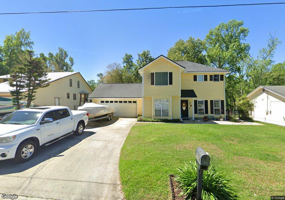
2014 Cornell Rd Middleburg, FL 32068
Estimated Value: $321,809 - $557,000
3
Beds
3
Baths
1,616
Sq Ft
$264/Sq Ft
Est. Value
About This Home
This home is located at 2014 Cornell Rd, Middleburg, FL 32068 and is currently estimated at $425,952, approximately $263 per square foot. 2014 Cornell Rd is a home located in Clay County with nearby schools including Middleburg Elementary School, Middleburg High School, and Lake Asbury Junior High School.
Ownership History
Date
Name
Owned For
Owner Type
Purchase Details
Closed on
Aug 13, 2003
Sold by
Justino Robert E and Justino Mary T
Bought by
Yale Dwayne A and Yale Debra
Current Estimated Value
Home Financials for this Owner
Home Financials are based on the most recent Mortgage that was taken out on this home.
Original Mortgage
$170,000
Outstanding Balance
$74,144
Interest Rate
5.72%
Mortgage Type
Purchase Money Mortgage
Estimated Equity
$351,808
Create a Home Valuation Report for This Property
The Home Valuation Report is an in-depth analysis detailing your home's value as well as a comparison with similar homes in the area
Home Values in the Area
Average Home Value in this Area
Purchase History
| Date | Buyer | Sale Price | Title Company |
|---|---|---|---|
| Yale Dwayne A | $220,000 | Realty Title Svcs Ne Fl Inc |
Source: Public Records
Mortgage History
| Date | Status | Borrower | Loan Amount |
|---|---|---|---|
| Open | Yale Dwayne A | $170,000 |
Source: Public Records
Tax History
| Year | Tax Paid | Tax Assessment Tax Assessment Total Assessment is a certain percentage of the fair market value that is determined by local assessors to be the total taxable value of land and additions on the property. | Land | Improvement |
|---|---|---|---|---|
| 2025 | $1,873 | $169,157 | -- | -- |
| 2024 | $2,359 | $164,390 | -- | -- |
| 2023 | $2,359 | $159,602 | $0 | $0 |
| 2022 | $2,178 | $154,954 | $0 | $0 |
| 2021 | $1,959 | $150,441 | $0 | $0 |
| 2020 | $2,106 | $148,364 | $0 | $0 |
| 2019 | $2,075 | $145,029 | $0 | $0 |
| 2018 | $1,918 | $142,325 | $0 | $0 |
| 2017 | $1,907 | $139,398 | $0 | $0 |
| 2016 | $1,902 | $136,531 | $0 | $0 |
| 2015 | $1,949 | $135,582 | $0 | $0 |
| 2014 | $1,905 | $134,506 | $0 | $0 |
Source: Public Records
Map
Nearby Homes
- 2139 2143 Charter Pointe Way
- 0 Charter Pointe Way
- 2051 Cornell Rd
- 2060 Cornell Rd
- 0 Main St Unit 2099304
- 3716 Main St
- 0 Blanding Blvd Unit 2103998
- 2326 North St
- 2246 Palisade Point
- 2498 Jennings Farm Dr
- 2280 Brannings Sawmill Ct
- 2487 Jennings Farm Dr
- 2264 Brannings Sawmill Ct
- 2260 Brannings Sawmill Ct
- 2230 Palisade Point
- 2481 Jennings Farm Dr
- 2475 Jennings Farm Dr
- 2265 Brannings Sawmill Ct
- 2220 Palisade Point
- 3775 Forest Dr
- 2018 Cornell Rd
- 2012 Cornell Rd
- 2015 Cornell Rd
- 2026 Cornell Rd
- 2011 Cornell Rd
- 2019 Cornell Rd
- 2006 Cornell Rd
- 2007 Cornell Rd
- 2008 Cornell Rd
- 2023 Cornell Rd
- 2002 Cornell Rd
- 2003 Cornell Rd
- 2032 Cornell Rd
- 0 Spinnaker Ct
- 2100 Spinnaker Ct
- 1999 Cornell Rd
- 2000 Cornell Rd
- 2036 Cornell Rd
- 2040 Cornell Rd
- 2113 Spinnaker Ct
Your Personal Tour Guide
Ask me questions while you tour the home.