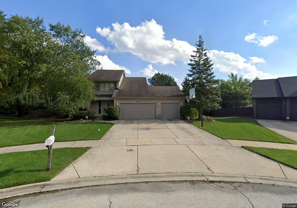
2014 Sheridan Ct Buffalo Grove, IL 60089
Rolling Hills NeighborhoodEstimated Value: $736,900 - $952,000
--
Bed
3
Baths
2,736
Sq Ft
$301/Sq Ft
Est. Value
About This Home
This home is located at 2014 Sheridan Ct, Buffalo Grove, IL 60089 and is currently estimated at $823,475, approximately $300 per square foot. 2014 Sheridan Ct is a home located in Lake County with nearby schools including Ivy Hall Elementary School, Twin Groves Middle School, and Adlai E Stevenson High School.
Ownership History
Date
Name
Owned For
Owner Type
Purchase Details
Closed on
Dec 16, 1999
Sold by
Klinsky Mitchell F and Klinsky Marne L
Bought by
Brown Arnold M and Brown Linda R
Current Estimated Value
Home Financials for this Owner
Home Financials are based on the most recent Mortgage that was taken out on this home.
Original Mortgage
$135,000
Outstanding Balance
$41,751
Interest Rate
7.7%
Estimated Equity
$781,724
Purchase Details
Closed on
Aug 11, 1995
Sold by
American National Bk & Tr Co Of Chicago
Bought by
Klinsky Mitchell F and Klinsky Marne L
Home Financials for this Owner
Home Financials are based on the most recent Mortgage that was taken out on this home.
Original Mortgage
$100,000
Interest Rate
8%
Create a Home Valuation Report for This Property
The Home Valuation Report is an in-depth analysis detailing your home's value as well as a comparison with similar homes in the area
Home Values in the Area
Average Home Value in this Area
Purchase History
| Date | Buyer | Sale Price | Title Company |
|---|---|---|---|
| Brown Arnold M | $450,000 | First American Title | |
| Klinsky Mitchell F | $329,000 | Chicago Title Insurance Co |
Source: Public Records
Mortgage History
| Date | Status | Borrower | Loan Amount |
|---|---|---|---|
| Open | Brown Arnold M | $135,000 | |
| Previous Owner | Klinsky Mitchell F | $100,000 |
Source: Public Records
Tax History Compared to Growth
Tax History
| Year | Tax Paid | Tax Assessment Tax Assessment Total Assessment is a certain percentage of the fair market value that is determined by local assessors to be the total taxable value of land and additions on the property. | Land | Improvement |
|---|---|---|---|---|
| 2024 | $17,261 | $197,670 | $56,912 | $140,758 |
| 2023 | $16,273 | $177,635 | $51,144 | $126,491 |
| 2022 | $16,273 | $165,369 | $47,612 | $117,757 |
| 2021 | $15,753 | $163,586 | $47,099 | $116,487 |
| 2020 | $15,444 | $164,144 | $47,260 | $116,884 |
| 2019 | $16,334 | $176,747 | $47,086 | $129,661 |
| 2018 | $15,707 | $180,871 | $51,186 | $129,685 |
| 2017 | $16,018 | $176,649 | $49,991 | $126,658 |
| 2016 | $16,156 | $180,482 | $47,870 | $132,612 |
| 2015 | $16,172 | $168,786 | $44,768 | $124,018 |
| 2014 | $16,161 | $166,028 | $48,081 | $117,947 |
| 2012 | $15,695 | $166,360 | $48,177 | $118,183 |
Source: Public Records
Map
Nearby Homes
- 1998 Sheridan Ct
- 1903 Sheridan Rd
- 1901 Brandywyn Ln
- 486 Satinwood Terrace Unit 11
- 5255 Danbury Ct
- 333 Didier Ct
- 5328 Oak Grove Dr
- 268 Hoffmann Dr
- 361 Hoffmann Dr
- 538 Lasalle Ct
- 361 Willow Pkwy Unit 234
- 259 Willow Pkwy Unit 403
- 327 Lasalle Ln
- 890 Knollwood Dr
- 2770 Sandalwood Rd Unit 3
- 2033 Olive Hill Dr
- 2071 Wright Blvd
- 896 Chaucer Way Unit 2
- 1265 Devonshire Rd
- 5107 N Arlington Heights Rd
- 2018 Sheridan Ct
- 2010 Sheridan Ct
- 1940 Beverly Ln
- 790 Edgemere Rd
- 1944 Beverly Ln
- 800 Edgemere Rd
- 2022 Sheridan Ct
- 1936 Beverly Ln
- 2006 Sheridan Ct
- 1948 Beverly Ln
- 810 Edgemere Rd
- 2002 Sheridan Ct
- 1954 Sheridan Rd
- 2026 Sheridan Ct
- 2030 Sheridan Rd
- 1958 Sheridan Rd
- 1952 Beverly Ln
- 1949 Beverly Ln
- 791 Edgemere Rd
- 1945 Beverly Ln