
2014 W Sandusky St Findlay, OH 45840
Estimated payment $2,025/month
Highlights
- Popular Property
- 0.74 Acre Lot
- No HOA
- Liberty-Benton Elementary School Rated A-
- Main Floor Primary Bedroom
- Breakfast Room
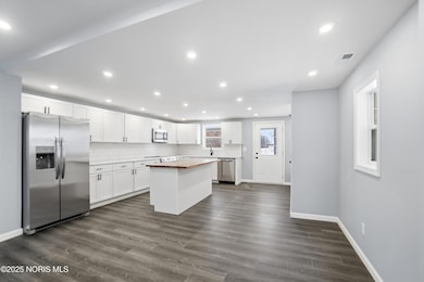
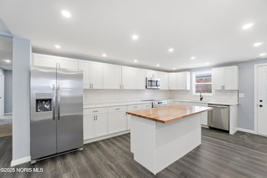
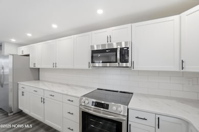
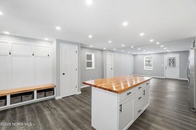
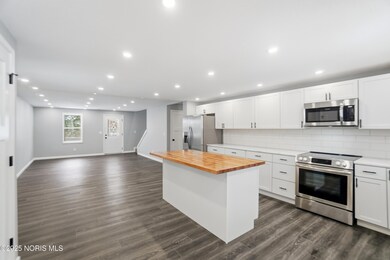
About This Home
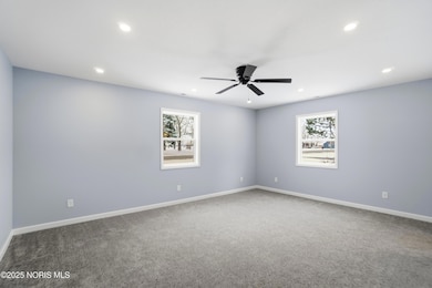
Step inside this fully renovated turn key home located in Liberty-Benton School District! Set on a 0.76 acre lot, this property blends the convenience of city living with the privacy and room to breathe. The inviting layout features a first-floor primary suite designed for comfort and convenience. The home offers 4 additional bedrooms across the main and second floors, along with 2 additional full bathrooms, providing exceptional space for family and guests. Enjoy cooking and gathering in the bright eat-in kitchen, or unwind outdoors on the large covered back patio, perfect for relaxing evenings or entertaining friends. With its modern updates, generous living spaces, and an impressive lot size close to everything Findlay offers, this home is truly move-in ready!!

Open House Schedule
-
Saturday, December 13, 202511:00 am to 1:00 pm12/13/2025 11:00:00 AM +00:0012/13/2025 1:00:00 PM +00:00Add to Calendar
Home Details
Home Type
- Single Family
Est. Annual Taxes
- $1,644
Year Built
- Built in 1936
Lot Details
- 0.74 Acre Lot
- Lot Dimensions are 152x215
Parking
- 2 Car Garage
- Driveway
Home Design
- Shingle Roof
- Vinyl Siding
Interior Spaces
- 2,200 Sq Ft Home
- 2-Story Property
- Family Room
- Breakfast Room
- Laundry on main level
Kitchen
- Electric Range
- Microwave
- Dishwasher
Flooring
- Carpet
- Vinyl
Bedrooms and Bathrooms
- 5 Bedrooms
- Primary Bedroom on Main
- Walk-In Closet
- 3 Full Bathrooms
Schools
- Liberty - Benton Elementary And Middle School
- Liberty - Benton High School
Utilities
- Forced Air Heating and Cooling System
- Heating System Uses Natural Gas
- Water Heater
Community Details
- No Home Owners Association
Listing and Financial Details
- Assessor Parcel Number 280000064350
Map
Home Values in the Area
Average Home Value in this Area
Tax History
| Year | Tax Paid | Tax Assessment Tax Assessment Total Assessment is a certain percentage of the fair market value that is determined by local assessors to be the total taxable value of land and additions on the property. | Land | Improvement |
|---|---|---|---|---|
| 2024 | $1,644 | $44,220 | $6,280 | $37,940 |
| 2023 | $1,605 | $44,220 | $6,280 | $37,940 |
| 2022 | $1,589 | $44,220 | $6,280 | $37,940 |
| 2021 | $1,315 | $32,290 | $6,280 | $26,010 |
| 2020 | $1,326 | $32,290 | $6,280 | $26,010 |
| 2019 | $1,272 | $32,290 | $6,280 | $26,010 |
| 2018 | $1,010 | $28,080 | $5,460 | $22,620 |
| 2017 | $517 | $28,080 | $5,460 | $22,620 |
| 2016 | $1,015 | $28,080 | $5,460 | $22,620 |
| 2015 | $739 | $20,190 | $5,460 | $14,730 |
| 2014 | $1,092 | $20,190 | $5,460 | $14,730 |
| 2012 | $1,127 | $20,190 | $5,460 | $14,730 |
Property History
| Date | Event | Price | List to Sale | Price per Sq Ft |
|---|---|---|---|---|
| 12/04/2025 12/04/25 | For Sale | $359,900 | -- | $164 / Sq Ft |
Purchase History
| Date | Type | Sale Price | Title Company |
|---|---|---|---|
| Warranty Deed | $52,500 | Golden Key Title | |
| Warranty Deed | $52,500 | Golden Key Title | |
| Deed | $25,000 | -- |
Source: Northwest Ohio Real Estate Information Service (NORIS)
MLS Number: 10002012
APN: 28-0000064350
Disclaimer: Certain information contained herein is derived from information provided by parties other than Homes.com. All information provided is deemed reliable, but is not guaranteed to be accurate and should be independently verified.
![]() IDX information is provided exclusively for personal, non-commercial use, and may not be used for any purpose other than to identify prospective properties consumers may be interested in purchasing. Information is deemed reliable but not guaranteed. ©2025 NORIS. All rights reserved.
IDX information is provided exclusively for personal, non-commercial use, and may not be used for any purpose other than to identify prospective properties consumers may be interested in purchasing. Information is deemed reliable but not guaranteed. ©2025 NORIS. All rights reserved.
- 2201 W Main Cross St
- 425 Nevada Ln
- 535 Palm Dr
- 9307 Hiegel Dr
- 0 Waterford Way Lot 78 Unit 6089639
- 9220 Colonel Dr
- 9653 Early Dr
- 8256 Silverwood Dr
- 8179 Hazelwood Dr
- 9307 W State Route 12
- 0 Bushwillow Dr Unit Lot 154
- 0 Bushwillow Dr Lot 156 Unit 6079046
- 0 Rock Candy Rd Lot 162 Unit 6079070
- 0 Bushwillow Dr Unit Lot 156
- 0 Bearcat Way Or 0 Rock Candy Rd Lot 167 Unit 6079083
- 0 Bushwillow Dr Lot 154 Unit 6079043
- 0 Rock Candy Rd Lot 171 Unit 6079088
- 0 County Road 99 Lot 2 Unit 6081480
- 0 Rock Candy Rd Lot 159 Unit 6079053
- 0 Bushwillow Dr Or Rock Candy Rd Lot 157 Unit 6079052
- 160 Colonial Dr
- 1200 Putnam St
- 609 Lima Ave
- 913 Fox St
- 318 W Crawford St
- 300 Washington St Unit B
- 219 Washington St Unit B
- 207 Washington St Unit B
- 411 W Mcpherson Ave
- 222 S Main St Unit 2
- 624 1/2 S Main St Unit 7
- 320 S Main St Unit C
- 626 S Main St Unit 2
- 868 1/2 S Main St Unit 2
- 118 E Sandusky St Unit 1
- 634 W Foulke Ave Unit 5
- 634 W Foulke Ave Unit 4
- 133 Defiance Ave Unit Front
- 118 Center St Unit A
- 328 Clinton St Unit Upper