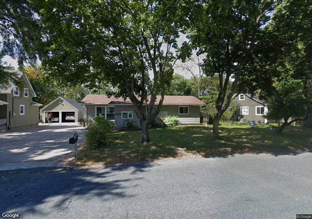
2015 2nd St W Unit W Menomonie, WI 54751
Estimated Value: $228,000 - $268,000
3
Beds
2
Baths
--
Sq Ft
8,712
Sq Ft Lot
About This Home
This home is located at 2015 2nd St W Unit W, Menomonie, WI 54751 and is currently estimated at $249,940. 2015 2nd St W Unit W is a home located in Dunn County with nearby schools including River Heights Elementary School, Menomonie Middle School, and Menomonie High School.
Ownership History
Date
Name
Owned For
Owner Type
Purchase Details
Closed on
Oct 16, 2023
Sold by
Donaghue Russell W and Donaghue Jennifer J.
Bought by
Gifford Corrie
Current Estimated Value
Purchase Details
Closed on
May 14, 2021
Sold by
Haupt Duane E
Bought by
Donaghue Russell W
Home Financials for this Owner
Home Financials are based on the most recent Mortgage that was taken out on this home.
Interest Rate
2.94%
Create a Home Valuation Report for This Property
The Home Valuation Report is an in-depth analysis detailing your home's value as well as a comparison with similar homes in the area
Home Values in the Area
Average Home Value in this Area
Purchase History
| Date | Buyer | Sale Price | Title Company |
|---|---|---|---|
| Gifford Corrie | $207,000 | Dunn Co. Title Services, Inc. | |
| Donaghue Russell W | $67,000 | -- | |
| Donaghue Russell W | $67,000 | -- |
Source: Public Records
Mortgage History
| Date | Status | Borrower | Loan Amount |
|---|---|---|---|
| Previous Owner | Donaghue Russell W | -- |
Source: Public Records
Tax History Compared to Growth
Tax History
| Year | Tax Paid | Tax Assessment Tax Assessment Total Assessment is a certain percentage of the fair market value that is determined by local assessors to be the total taxable value of land and additions on the property. | Land | Improvement |
|---|---|---|---|---|
| 2024 | $3,123 | $155,600 | $16,000 | $139,600 |
| 2023 | $2,999 | $155,600 | $16,000 | $139,600 |
| 2022 | $2,863 | $155,600 | $16,000 | $139,600 |
| 2021 | $3,004 | $155,600 | $16,000 | $139,600 |
| 2020 | $2,930 | $115,300 | $13,000 | $102,300 |
| 2019 | $2,585 | $115,300 | $13,000 | $102,300 |
| 2018 | $2,548 | $115,300 | $13,000 | $102,300 |
| 2017 | $2,690 | $115,300 | $13,000 | $102,300 |
| 2016 | $2,623 | $115,300 | $13,000 | $102,300 |
| 2015 | $2,643 | $115,300 | $13,000 | $102,300 |
| 2014 | $2,671 | $115,300 | $13,000 | $102,300 |
| 2013 | $2,704 | $115,300 | $13,000 | $102,300 |
Source: Public Records
Map
Nearby Homes
- 2003 Broadway St S
- 2202 Broadway St S
- 2419 Fryklund Dr
- 1321 2nd St W
- 422 12th Ave W
- 422 12th Ave W Unit 1
- 207 12th Ave W
- N4856 460th St
- 1708 8th St E
- 1115 7th St E Unit 1
- 1115 7th St E
- 921 14th Ave E
- 1121 River Heights Rd
- 913 8th St E Unit 1 & 2
- 1314 16th Ave E
- 1400 12th Ave E
- 813 Oakwood Blvd
- 503 11th St E
- E4382 462nd Ave
- 502 12th St SE
- 2015 2nd St W
- 2015 2015 2nd-Street-w
- 2021 2nd St W
- 2007 2nd St W
- 2003 2nd St W
- 2020 3rd St W
- 2010 3rd St W
- 208 21st Ave E
- 121 21st Ave W
- 208 21st Ave W
- 2010 2nd St W
- 118 20th Ave W
- 203 20th Ave W
- 214 21st Ave W
- 2109 2nd St W
- 303 21st Ave W
- 1916 3rd St W
- 1917 2nd St E
- 119 20th Ave W
- 2015 Broadway St S