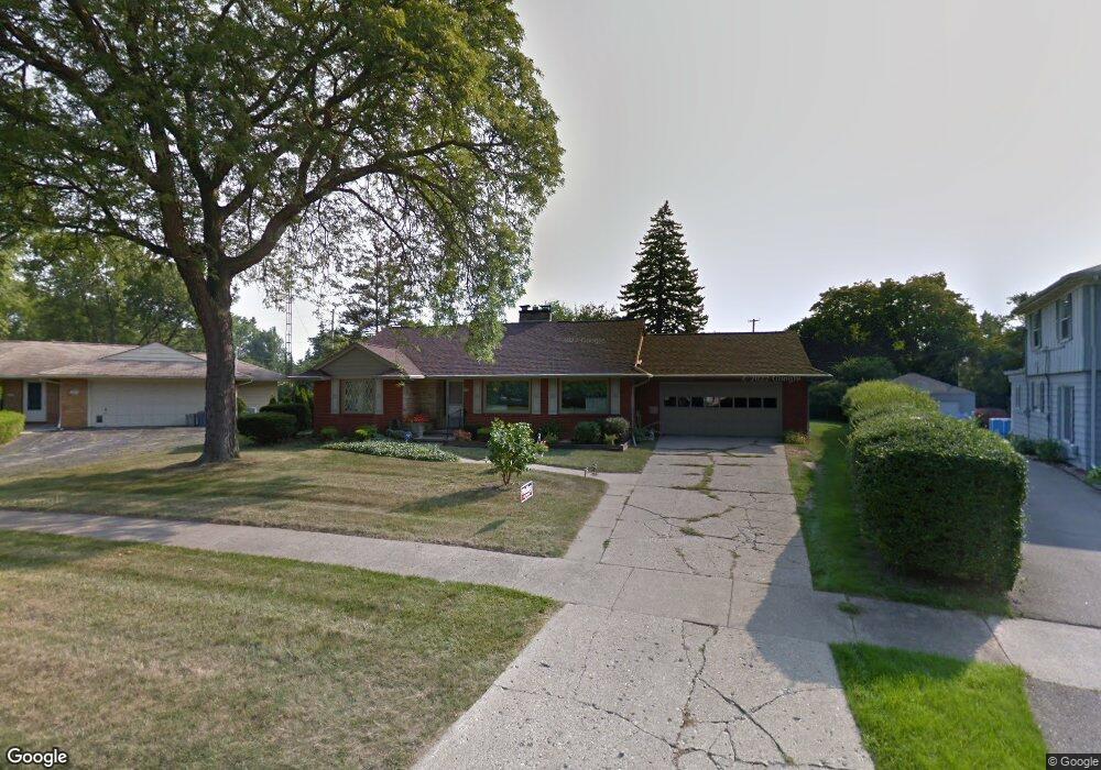
2015 Crooked Ln Flint, MI 48503
Woodcroft Estates NeighborhoodEstimated Value: $177,582 - $216,000
2
Beds
2
Baths
1,528
Sq Ft
$132/Sq Ft
Est. Value
About This Home
This home is located at 2015 Crooked Ln, Flint, MI 48503 and is currently estimated at $201,146, approximately $131 per square foot. 2015 Crooked Ln is a home located in Genesee County with nearby schools including Durant-Tuuri-Mott Elementary School, Flint Southwestern Classical Academy, and St. Paul Lutheran School.
Ownership History
Date
Name
Owned For
Owner Type
Purchase Details
Closed on
Dec 12, 2017
Sold by
Braun Wendy
Bought by
Daly John H and Braun Wendy
Current Estimated Value
Purchase Details
Closed on
Sep 26, 2007
Sold by
Baker Barbara Helen and Baker Sara A
Bought by
Braun Wendy
Purchase Details
Closed on
Feb 7, 2007
Sold by
Skaff Helen and Baker Harold W
Bought by
Baker Barbara Helen and Baker Sara A
Create a Home Valuation Report for This Property
The Home Valuation Report is an in-depth analysis detailing your home's value as well as a comparison with similar homes in the area
Home Values in the Area
Average Home Value in this Area
Purchase History
| Date | Buyer | Sale Price | Title Company |
|---|---|---|---|
| Daly John H | -- | None Available | |
| Braun Wendy | $90,000 | Sargents Title Company | |
| Baker Barbara Helen | -- | Sargents Title Company |
Source: Public Records
Tax History
| Year | Tax Paid | Tax Assessment Tax Assessment Total Assessment is a certain percentage of the fair market value that is determined by local assessors to be the total taxable value of land and additions on the property. | Land | Improvement |
|---|---|---|---|---|
| 2025 | $2,112 | $89,100 | $0 | $0 |
| 2024 | $1,874 | $83,800 | $0 | $0 |
| 2023 | $1,819 | $77,500 | $0 | $0 |
| 2022 | $0 | $67,500 | $0 | $0 |
| 2021 | $1,917 | $62,200 | $0 | $0 |
| 2020 | $1,689 | $56,300 | $0 | $0 |
| 2019 | $1,620 | $56,300 | $0 | $0 |
| 2018 | $1,706 | $53,300 | $0 | $0 |
| 2017 | $1,649 | $0 | $0 | $0 |
| 2016 | $1,637 | $0 | $0 | $0 |
| 2015 | -- | $0 | $0 | $0 |
| 2014 | -- | $0 | $0 | $0 |
| 2012 | -- | $33,300 | $0 | $0 |
Source: Public Records
Map
Nearby Homes
- 3102 Westwood Pkwy
- 3402 Brandon St
- 3506 Chicago Blvd
- 3214 Clairmont St
- 3510 Hogarth Ave
- 2729 Chicago Blvd
- 3217 Arlene Ave
- 3317 Arlene Ave
- 2624 Miller Rd
- 3722 Larchmont St
- 1308 Barney Ave
- 1412 S Ballenger Hwy
- 1202 Knapp Ave
- 1114 Clancy Ave
- 2608 Cumings Ave
- 1122 Stocker Ave
- 3918 Larchmont St
- 2618 Brown St
- 3413 Augusta St
- 3825 Arlene Ave
- 2023 Crooked Ln
- 2031 Crooked Ln Unit Bldg-Unit
- 2031 Crooked Ln
- 2014 Oxford Ln
- 2022 Oxford Ln
- 2007 Crooked Ln
- 2034 Oxford Ln
- 2039 Crooked Ln
- 3101 Hawthorne Dr
- 3030 Westwood Pkwy
- 3110 Westwood Pkwy
- 2002 Crooked Ln
- 2020 Crooked Ln
- 3120 Westwood Pkwy
- 2040 Oxford Ln
- 3020 Westwood Pkwy
- 3130 Westwood Pkwy
- 3211 Hawthorne Dr
- 2038 Crooked Ln
- 2011 Oxford Ln