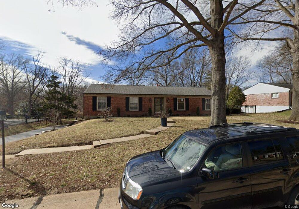
2015 Firethorn Dr Saint Louis, MO 63131
Estimated Value: $606,081 - $686,000
4
Beds
2
Baths
2,008
Sq Ft
$321/Sq Ft
Est. Value
About This Home
This home is located at 2015 Firethorn Dr, Saint Louis, MO 63131 and is currently estimated at $644,520, approximately $320 per square foot. 2015 Firethorn Dr is a home located in St. Louis County with nearby schools including Westchester Elementary School, North Kirkwood Middle School, and Kirkwood Senior High School.
Ownership History
Date
Name
Owned For
Owner Type
Purchase Details
Closed on
Dec 5, 2019
Sold by
Neal Timothy R O
Bought by
Barbara Martin Revocable Living Trust
Current Estimated Value
Home Financials for this Owner
Home Financials are based on the most recent Mortgage that was taken out on this home.
Original Mortgage
$312,000
Interest Rate
3.7%
Mortgage Type
New Conventional
Purchase Details
Closed on
Dec 26, 2007
Sold by
Barth Vera A
Bought by
Oneal Timothy R
Home Financials for this Owner
Home Financials are based on the most recent Mortgage that was taken out on this home.
Original Mortgage
$232,000
Interest Rate
6.23%
Mortgage Type
Purchase Money Mortgage
Purchase Details
Closed on
Aug 24, 2007
Sold by
Barth Vera A
Bought by
Barth Vera A and Vera A Barth Revocable Trust
Purchase Details
Closed on
May 22, 1997
Sold by
Barth Edward V and Barth Vera A
Bought by
Barth Vera A
Create a Home Valuation Report for This Property
The Home Valuation Report is an in-depth analysis detailing your home's value as well as a comparison with similar homes in the area
Home Values in the Area
Average Home Value in this Area
Purchase History
| Date | Buyer | Sale Price | Title Company |
|---|---|---|---|
| Barbara Martin Revocable Living Trust | $410,000 | Clear Title Group | |
| Oneal Timothy R | $290,000 | Ort | |
| Barth Vera A | -- | None Available | |
| Barth Vera A | -- | -- |
Source: Public Records
Mortgage History
| Date | Status | Borrower | Loan Amount |
|---|---|---|---|
| Previous Owner | Barbara Martin Revocable Living Trust | $312,000 | |
| Previous Owner | Oneal Timothy R | $232,000 |
Source: Public Records
Tax History Compared to Growth
Tax History
| Year | Tax Paid | Tax Assessment Tax Assessment Total Assessment is a certain percentage of the fair market value that is determined by local assessors to be the total taxable value of land and additions on the property. | Land | Improvement |
|---|---|---|---|---|
| 2025 | $5,309 | $110,850 | $70,590 | $40,260 |
| 2024 | $5,309 | $91,710 | $57,340 | $34,370 |
| 2023 | $5,227 | $91,710 | $57,340 | $34,370 |
| 2022 | $4,978 | $81,390 | $57,340 | $24,050 |
| 2021 | $4,924 | $81,390 | $57,340 | $24,050 |
| 2020 | $4,504 | $71,530 | $32,600 | $38,930 |
| 2019 | $4,509 | $71,530 | $32,600 | $38,930 |
| 2018 | $4,788 | $68,170 | $27,680 | $40,490 |
| 2017 | $4,800 | $68,170 | $27,680 | $40,490 |
| 2016 | $4,360 | $62,680 | $27,680 | $35,000 |
| 2015 | $4,365 | $62,680 | $27,680 | $35,000 |
| 2014 | $3,921 | $54,990 | $22,210 | $32,780 |
Source: Public Records
Map
Nearby Homes
- 1741 Pine Hill Dr
- 1728 Folkstone Dr
- 723 Oak Valley Dr
- 8 Briarbrook Trail
- 22 Countryside Ln
- 152 Frontenac Forest
- TBB Ballas Ridge Hawthorne II
- TBB
- TBB Ballas Ridge Roclare II
- TBB Ballas Ridge Westchester IV
- The Hawthorne Plan at Ballas Ridge
- The Roclare II Plan at Ballas Ridge
- The Westchester IV Plan at Ballas Ridge
- The Nottingham II Plan at Ballas Ridge
- The Hawthorne II Plan at Ballas Ridge
- TBB
- 2056 N Ballas Rd
- 2062 N Ballas Rd
- 1345 Woodgate Dr
- 1126 Bopp Rd
- 2021 Firethorn Dr
- 2007 Firethorn Dr
- 2034 Willow Leaf Dr
- 2040 Willow Leaf Dr
- 2016 Willow Leaf Dr
- 2027 Firethorn Dr
- 2012 Firethorn Dr
- 2001 Firethorn Dr
- 2018 Firethorn Dr
- 2006 Firethorn Dr
- 2046 Willow Leaf Dr
- 2024 Firethorn Dr
- 2033 Firethorn Dr
- 2000 Firethorn Dr
- 2052 Willow Leaf Dr
- 2030 Firethorn Dr
- 2035 Willow Leaf Dr
- 2011 Willow Leaf Dr
- 1944 Firethorn Dr
- 2017 Willow Leaf Dr