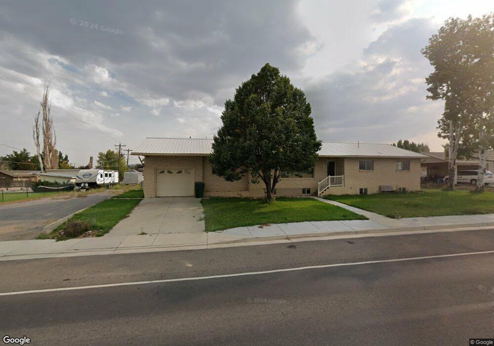
2015 W 500 S Vernal, UT 84078
Estimated Value: $315,000 - $425,000
4
Beds
3
Baths
1,630
Sq Ft
$232/Sq Ft
Est. Value
About This Home
This home is located at 2015 W 500 S, Vernal, UT 84078 and is currently estimated at $378,828, approximately $232 per square foot. 2015 W 500 S is a home located in Uintah County with nearby schools including Discovery School, Vernal Middle School, and Uintah Middle School.
Ownership History
Date
Name
Owned For
Owner Type
Purchase Details
Closed on
Apr 12, 2024
Sold by
Ames Karen
Bought by
Kummer Lawrence Boone and Kummer Kiara M
Current Estimated Value
Home Financials for this Owner
Home Financials are based on the most recent Mortgage that was taken out on this home.
Original Mortgage
$230,250
Outstanding Balance
$226,426
Interest Rate
6.94%
Mortgage Type
New Conventional
Estimated Equity
$152,402
Purchase Details
Closed on
Oct 29, 2007
Sold by
Burns Marlies
Bought by
Burns Marlies
Purchase Details
Closed on
Aug 16, 2007
Sold by
Migliore Mitchell T
Bought by
Burns Marlies
Home Financials for this Owner
Home Financials are based on the most recent Mortgage that was taken out on this home.
Original Mortgage
$239,400
Interest Rate
6.62%
Mortgage Type
New Conventional
Purchase Details
Closed on
Jul 20, 2007
Sold by
Siavrakas Christopher
Bought by
Migliori Mitchell T
Home Financials for this Owner
Home Financials are based on the most recent Mortgage that was taken out on this home.
Original Mortgage
$239,400
Interest Rate
6.62%
Mortgage Type
New Conventional
Purchase Details
Closed on
Feb 22, 2006
Sold by
Migliori Mitchell T and Migliori Karen B
Bought by
Siavrakas Christopher
Home Financials for this Owner
Home Financials are based on the most recent Mortgage that was taken out on this home.
Original Mortgage
$144,000
Interest Rate
6.15%
Mortgage Type
New Conventional
Purchase Details
Closed on
Oct 7, 2005
Sold by
Migliori Mitch
Bought by
Migliori Mitchell T and Migliori Karen B
Home Financials for this Owner
Home Financials are based on the most recent Mortgage that was taken out on this home.
Original Mortgage
$133,600
Interest Rate
1%
Mortgage Type
Adjustable Rate Mortgage/ARM
Purchase Details
Closed on
Jun 21, 2005
Sold by
Dee & Guy Collett Llc
Bought by
Migliori Mitch
Home Financials for this Owner
Home Financials are based on the most recent Mortgage that was taken out on this home.
Original Mortgage
$22,000
Interest Rate
5.2%
Mortgage Type
Stand Alone Second
Create a Home Valuation Report for This Property
The Home Valuation Report is an in-depth analysis detailing your home's value as well as a comparison with similar homes in the area
Purchase History
| Date | Buyer | Sale Price | Title Company |
|---|---|---|---|
| Kummer Lawrence Boone | -- | None Listed On Document | |
| Ames Karen | -- | Farm And Home Title | |
| Burns Marlies | -- | -- | |
| Burns Marlies | -- | -- | |
| Migliori Mitchell T | -- | -- | |
| Siavrakas Christopher | -- | -- | |
| Migliori Mitchell T | -- | -- | |
| Migliori Mitch | -- | -- |
Source: Public Records
Mortgage History
| Date | Status | Borrower | Loan Amount |
|---|---|---|---|
| Open | Kummer Lawrence Boone | $230,250 | |
| Previous Owner | Burns Marlies | $239,400 | |
| Previous Owner | Siavrakas Christopher | $144,000 | |
| Previous Owner | Migliori Mitchell T | $133,600 | |
| Previous Owner | Migliori Mitch | $22,000 | |
| Previous Owner | Migliori Mitch | $88,000 |
Source: Public Records
Tax History
| Year | Tax Paid | Tax Assessment Tax Assessment Total Assessment is a certain percentage of the fair market value that is determined by local assessors to be the total taxable value of land and additions on the property. | Land | Improvement |
|---|---|---|---|---|
| 2024 | $1,993 | $220,282 | $25,844 | $194,438 |
| 2023 | $1,967 | $175,235 | $23,614 | $151,621 |
| 2022 | $1,588 | $144,910 | $23,614 | $121,296 |
| 2021 | $1,621 | $67,226 | $12,988 | $54,238 |
| 2020 | $1,576 | $122,229 | $23,614 | $98,615 |
| 2019 | $1,341 | $102,592 | $19,250 | $83,342 |
| 2018 | $1,290 | $98,623 | $19,250 | $79,373 |
| 2017 | $13 | $101,373 | $22,000 | $79,373 |
| 2016 | $1,341 | $112,920 | $22,000 | $90,920 |
| 2015 | $1,292 | $117,705 | $22,000 | $95,705 |
| 2014 | $1,231 | $113,148 | $22,000 | $91,148 |
| 2013 | $1,256 | $113,148 | $22,000 | $91,148 |
Source: Public Records
Map
Nearby Homes
- 604 S 2150 W
- 743 S 1950 W
- 2230 W 700 S Unit 2236
- 835 S 2050 W Unit 12
- 1583 W Partridge Drive (560 S) S
- 1601 W 300 S Unit 57
- 50 S 1500 W Unit 126
- 50 S 1500 W Unit 7
- 50 S 1500 W Unit S27
- 50 S 1500 W Unit 5
- 50 S 1500 W Unit 11
- 50 S 1500 W Unit 105
- 50 S 1500 W Unit S9
- 50 S 1500 W Unit 9
- 1440 W 925 S
- 1453 975 S
- 1015 S 1500 W
- 142 S 1350 W
- 2805 W Highway 40
- 2648 W Highway 40