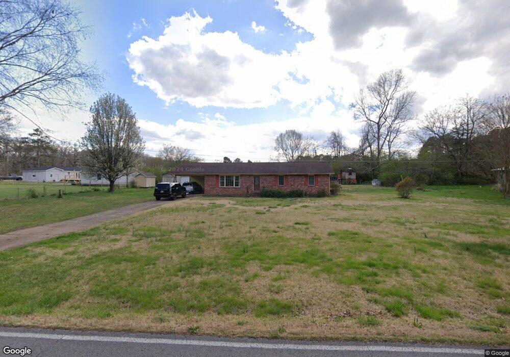
2016 Center Grove Rd Rock Spring, GA 30739
Rock Spring NeighborhoodEstimated Value: $238,705 - $330,000
--
Bed
2
Baths
1,428
Sq Ft
$194/Sq Ft
Est. Value
About This Home
This home is located at 2016 Center Grove Rd, Rock Spring, GA 30739 and is currently estimated at $277,676, approximately $194 per square foot. 2016 Center Grove Rd is a home located in Walker County with nearby schools including Rock Spring Elementary School, Lafayette High School, and Alice M Daley Adventist School.
Ownership History
Date
Name
Owned For
Owner Type
Purchase Details
Closed on
Mar 4, 1976
Sold by
Mathis C H
Bought by
Peterson Richard L
Current Estimated Value
Purchase Details
Closed on
Aug 28, 1971
Bought by
Mathis C H
Create a Home Valuation Report for This Property
The Home Valuation Report is an in-depth analysis detailing your home's value as well as a comparison with similar homes in the area
Home Values in the Area
Average Home Value in this Area
Purchase History
| Date | Buyer | Sale Price | Title Company |
|---|---|---|---|
| Peterson Richard L | $16,000 | -- | |
| Mathis C H | -- | -- |
Source: Public Records
Tax History Compared to Growth
Tax History
| Year | Tax Paid | Tax Assessment Tax Assessment Total Assessment is a certain percentage of the fair market value that is determined by local assessors to be the total taxable value of land and additions on the property. | Land | Improvement |
|---|---|---|---|---|
| 2024 | $200 | $90,529 | $9,539 | $80,990 |
| 2023 | $200 | $88,911 | $7,571 | $81,340 |
| 2022 | $143 | $76,935 | $6,323 | $70,612 |
| 2021 | $143 | $58,035 | $6,323 | $51,712 |
| 2020 | $143 | $47,599 | $6,323 | $41,276 |
| 2019 | $142 | $47,599 | $6,323 | $41,276 |
| 2018 | $1,259 | $47,599 | $6,323 | $41,276 |
| 2017 | $309 | $47,599 | $6,323 | $41,276 |
| 2016 | $130 | $47,599 | $6,323 | $41,276 |
| 2015 | $130 | $41,851 | $6,632 | $35,219 |
| 2014 | $65 | $41,851 | $6,632 | $35,219 |
| 2013 | -- | $41,850 | $6,632 | $35,218 |
Source: Public Records
Map
Nearby Homes
- 0 Tarvin Rd Unit 1523862
- 0 Colbert Hollow Rd Unit 1513202
- 0 Clyde Byrd Rd
- 0 Veeler Rd Unit 1522679
- 0 Veeler Rd Unit 10628696
- 0 Cheshire Crossing Dr Unit 1387793
- 287 E Teems Rd
- 265 Rodeo Dr
- 1585 E Reed Rd
- 5602 Georgia 95
- 00 Georgia 95
- 10180 Us Highway 27
- 0 E Teems Rd Unit 7573954
- 1186 E Reed Rd
- 15 Willow Cir
- 23 Willow Cir
- 16 Willow Cir
- 5062 Georgia 95
- 11 Willow Cir
- 1978 Center Grove Rd
- 2056 Center Grove Rd
- 224 Ringgold Rd
- 248 Ringgold Rd
- 2057 Center Grove Rd
- 254 Ringgold Rd
- 1993 Center Grove Rd
- 1910 Center Grove Rd
- 1910 Center Grove Rd
- 1871 Center Grove Rd
- 303 Ringgold Rd
- 70 Ringgold Rd
- 32 Ringgold Rd
- 360 Ringgold Rd
- 1839 Center Grove Rd
- 3406 Highway 95
- 3027 Highway 95
- 50 Bowman Ln
- 2909 Highway 95
- 30 Ringgold Rd