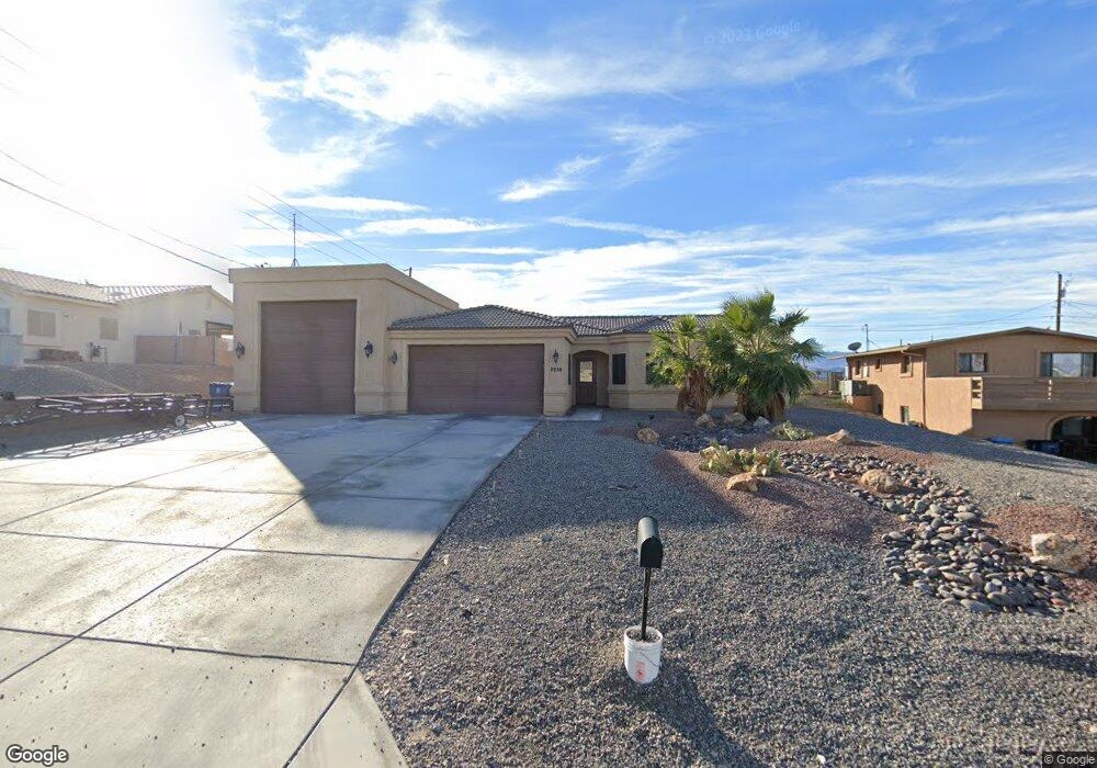
2016 Pima Dr N Lake Havasu City, AZ 86403
Estimated Value: $570,000 - $623,648
3
Beds
2
Baths
1,847
Sq Ft
$327/Sq Ft
Est. Value
About This Home
This home is located at 2016 Pima Dr N, Lake Havasu City, AZ 86403 and is currently estimated at $604,662, approximately $327 per square foot. 2016 Pima Dr N is a home located in Mohave County with nearby schools including Smoketree Elementary School, Thunderbolt Middle School, and Lake Havasu High School.
Ownership History
Date
Name
Owned For
Owner Type
Purchase Details
Closed on
Dec 23, 2016
Sold by
Harris Robert A and Harris Shonie
Bought by
Harris Robert Aldon and Harris Afton Shonie
Current Estimated Value
Purchase Details
Closed on
Oct 1, 2013
Sold by
Mtse Holdings 2012001 Llc
Bought by
Harris Robert and Harris Shonie
Purchase Details
Closed on
Feb 13, 2012
Sold by
Hollerich Larry A and Winrock Maribeth A
Bought by
Mtse Holdings 2012001 Llc
Purchase Details
Closed on
Oct 19, 2005
Sold by
Hollerich Clare K
Bought by
Hollerich Clare K
Create a Home Valuation Report for This Property
The Home Valuation Report is an in-depth analysis detailing your home's value as well as a comparison with similar homes in the area
Home Values in the Area
Average Home Value in this Area
Purchase History
| Date | Buyer | Sale Price | Title Company |
|---|---|---|---|
| Harris Robert Aldon | -- | None Available | |
| Harris Robert | -- | Stewart Title & Trust Of Pho | |
| Mtse Holdings 2012001 Llc | $30,000 | Stewart Title & Trust Of Pho | |
| Hollerich Clare K | -- | -- |
Source: Public Records
Tax History Compared to Growth
Tax History
| Year | Tax Paid | Tax Assessment Tax Assessment Total Assessment is a certain percentage of the fair market value that is determined by local assessors to be the total taxable value of land and additions on the property. | Land | Improvement |
|---|---|---|---|---|
| 2026 | -- | -- | -- | -- |
| 2025 | $2,483 | $53,318 | $0 | $0 |
| 2024 | $2,483 | $57,477 | $0 | $0 |
| 2023 | $2,483 | $50,942 | $0 | $0 |
| 2022 | $2,376 | $37,634 | $0 | $0 |
| 2021 | $2,564 | $33,679 | $0 | $0 |
| 2019 | $2,433 | $28,358 | $0 | $0 |
| 2018 | $2,349 | $26,904 | $0 | $0 |
| 2017 | $2,326 | $26,039 | $0 | $0 |
| 2016 | $2,101 | $24,084 | $0 | $0 |
| 2015 | $2,011 | $21,248 | $0 | $0 |
Source: Public Records
Map
Nearby Homes
- 2030 Mimosa Dr
- 1957 Mesquite Ave Unit 23B
- 1989 Mesquite Ave Unit 74
- 1989 Mesquite Ave Unit 32
- 1989 Mesquite Ave Unit 17
- 1989 Mesquite Ave Unit 46
- 2067 Palo Verde Blvd S
- 2075 Palo Verde Blvd S
- 0000 Sunrise Plan On Your Lot
- 2085 Mesquite Ave Unit 64
- 2085 Mesquite Ave Unit 61
- 2094 Mesquite Ave Unit 123
- 2094 Mesquite Ave Unit 113
- 2094 Mesquite Ave Unit 126
- 2095 Mesquite Ave Unit 19
- 1792 On Your Level
- 1700 On Your Level Lot
- 1910 Swanson Ave Unit A22
- 1910 Swanson Ave Unit A20
- 1910 Swanson Ave Unit B11