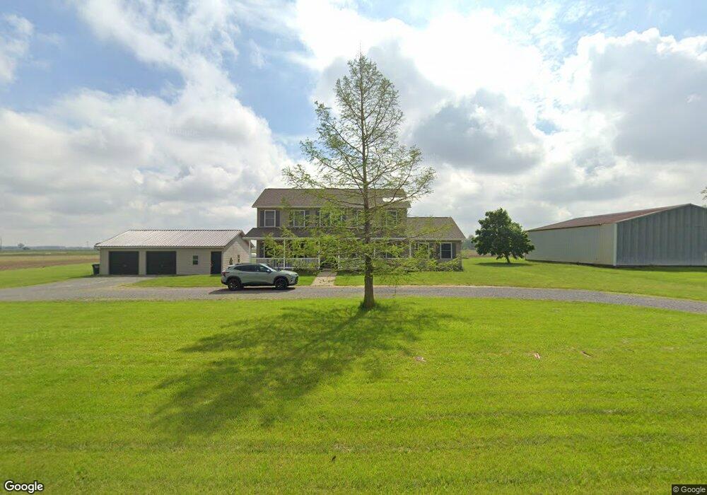
20165 State Route 116 Spencerville, OH 45887
Estimated Value: $288,000 - $358,000
4
Beds
4
Baths
2,912
Sq Ft
$115/Sq Ft
Est. Value
About This Home
This home is located at 20165 State Route 116, Spencerville, OH 45887 and is currently estimated at $335,127, approximately $115 per square foot. 20165 State Route 116 is a home located in Van Wert County with nearby schools including Spencerville Elementary School, Spencerville Middle School, and Spencerville High School.
Ownership History
Date
Name
Owned For
Owner Type
Purchase Details
Closed on
Mar 24, 2008
Sold by
Spence Gregory E and Spence April S
Bought by
Mcnulty James D and Mcnulty Karen
Current Estimated Value
Purchase Details
Closed on
Jun 19, 2006
Sold by
Cook Ruth E
Bought by
Spence Gregory E and Courtright April S
Purchase Details
Closed on
Mar 26, 2003
Bought by
Mcnulty James D and Mcnulty Karen
Purchase Details
Closed on
Mar 9, 2003
Bought by
Whetstone Edward L
Create a Home Valuation Report for This Property
The Home Valuation Report is an in-depth analysis detailing your home's value as well as a comparison with similar homes in the area
Home Values in the Area
Average Home Value in this Area
Purchase History
| Date | Buyer | Sale Price | Title Company |
|---|---|---|---|
| Mcnulty James D | $190,000 | Attorney | |
| Spence Gregory E | -- | None Available | |
| Mcnulty James D | $190,000 | -- | |
| Mcnulty James D | $190,000 | -- | |
| Whetstone Edward L | $6,000 | -- | |
| Whetstone Edward L | $6,000 | -- |
Source: Public Records
Tax History Compared to Growth
Tax History
| Year | Tax Paid | Tax Assessment Tax Assessment Total Assessment is a certain percentage of the fair market value that is determined by local assessors to be the total taxable value of land and additions on the property. | Land | Improvement |
|---|---|---|---|---|
| 2024 | $2,778 | $94,560 | $7,250 | $87,310 |
| 2023 | $2,778 | $94,560 | $7,250 | $87,310 |
| 2022 | $2,502 | $72,170 | $6,300 | $65,870 |
| 2021 | $2,493 | $72,170 | $6,300 | $65,870 |
| 2020 | $2,586 | $72,170 | $6,300 | $65,870 |
| 2019 | $2,258 | $65,360 | $5,430 | $59,930 |
| 2018 | $2,273 | $65,360 | $5,430 | $59,930 |
| 2017 | $2,217 | $65,360 | $5,430 | $59,930 |
| 2016 | $2,183 | $67,240 | $5,320 | $61,920 |
| 2015 | $2,211 | $67,240 | $5,320 | $61,920 |
| 2014 | $2,241 | $67,240 | $5,320 | $61,920 |
| 2013 | $2,430 | $67,240 | $5,320 | $61,920 |
Source: Public Records
Map
Nearby Homes
- 21183 Ohio 116
- 21197 Ohio 116
- 14101 Allentown Rd
- 21302 Masters Rd
- 440 W 4th St
- 409 W 4th St
- 336 W 4th St
- 406 S Mulberry St
- 00 Kleinoeder Rd
- 521 S Broadway St
- 408 N Mulberry St
- 425 N Main St
- 213 N Pearl St
- 316 E 4th St
- 123 Oakland Ave
- 714 Briggs Ave Unit 1
- 8323 Deep Cut Rd
- 19059 Wittington St
- 15044 Main St
- 19083 Venedocia Eastern Rd
- 20205 State Route 116
- 20418 State Route 117
- 20613 State Route 117
- 19968 Louth Rd
- 19910 Louth Rd
- 20347 State Route 116
- 19878 Louth Rd
- 20487 State Route 116
- 20570 State Route 116
- 20107 State Route 117
- 19897 Ohio 116
- 21037 Ohio 117
- 19911 State Route 116
- 19943 State Route 116
- 19897 State Route 116
- 20351 Biner Rd
- 19844 State Route 116
- 19572 Louth Rd
- 19897 St Route