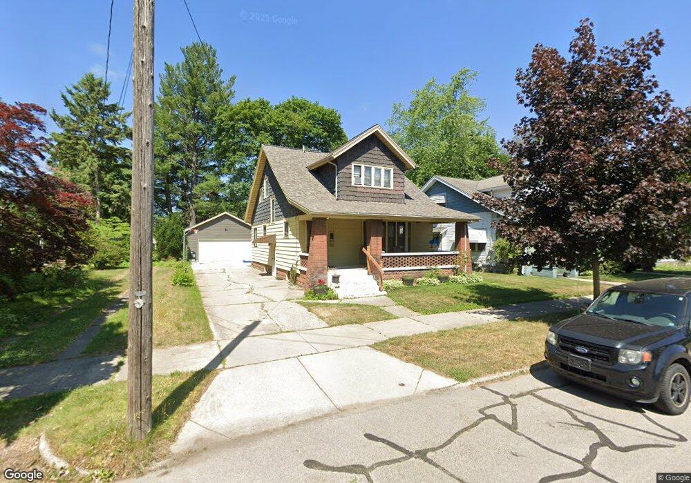
2017 Eastern Ave NE Grand Rapids, MI 49505
Creston NeighborhoodEstimated Value: $316,000 - $350,000
4
Beds
2
Baths
2,000
Sq Ft
$166/Sq Ft
Est. Value
About This Home
This home is located at 2017 Eastern Ave NE, Grand Rapids, MI 49505 and is currently estimated at $332,421, approximately $166 per square foot. 2017 Eastern Ave NE is a home located in Kent County with nearby schools including Riverside Middle School, Union High School, and ISJ Academy.
Ownership History
Date
Name
Owned For
Owner Type
Purchase Details
Closed on
Apr 14, 2006
Sold by
Sowers Ellis Jay and Sowers Beth E
Bought by
Richards John Thomas and Richards Dawnae
Current Estimated Value
Home Financials for this Owner
Home Financials are based on the most recent Mortgage that was taken out on this home.
Original Mortgage
$125,010
Outstanding Balance
$81,898
Interest Rate
9.35%
Mortgage Type
New Conventional
Estimated Equity
$250,523
Purchase Details
Closed on
Aug 21, 1986
Create a Home Valuation Report for This Property
The Home Valuation Report is an in-depth analysis detailing your home's value as well as a comparison with similar homes in the area
Home Values in the Area
Average Home Value in this Area
Purchase History
| Date | Buyer | Sale Price | Title Company |
|---|---|---|---|
| Richards John Thomas | $138,900 | None Available | |
| -- | $57,000 | -- |
Source: Public Records
Mortgage History
| Date | Status | Borrower | Loan Amount |
|---|---|---|---|
| Open | Richards John Thomas | $125,010 |
Source: Public Records
Tax History
| Year | Tax Paid | Tax Assessment Tax Assessment Total Assessment is a certain percentage of the fair market value that is determined by local assessors to be the total taxable value of land and additions on the property. | Land | Improvement |
|---|---|---|---|---|
| 2025 | $2,103 | $160,500 | $0 | $0 |
| 2024 | $21 | $148,600 | $0 | $0 |
| 2023 | $2,133 | $125,700 | $0 | $0 |
| 2022 | $2,025 | $106,400 | $0 | $0 |
| 2021 | $1,792 | $94,000 | $0 | $0 |
| 2020 | $1,713 | $88,700 | $0 | $0 |
| 2019 | $1,733 | $79,800 | $0 | $0 |
| 2018 | $1,733 | $71,400 | $0 | $0 |
| 2017 | $1,687 | $61,400 | $0 | $0 |
| 2016 | $1,707 | $56,700 | $0 | $0 |
| 2015 | $1,588 | $56,700 | $0 | $0 |
| 2013 | -- | $46,700 | $0 | $0 |
Source: Public Records
Map
Nearby Homes
- 2137 Eastern Ave NE
- 707 Graceland St NE
- 483 Kenwood St NE
- 414 Cheshire Dr NE
- 1651 Diamond Ave NE
- 1161 Dorroll St NE
- 2509 Belknap Ave NE
- 2512 Union Ave NE
- 1073 Sweet St NE
- 232 Dean St NE
- 1237 Dale Ct NE
- 147 Montrose St NE
- 1818 Carlton Ave NE
- 100 Knapp St NE
- 538 Spencer St NE
- 105 Dean St NE
- 317 Quimby St NE
- 1402 North Ave NE
- 631 3 Mile Rd NE
- 160 Boltwood Dr NE
- 2013 Eastern Ave NE
- 2023 Eastern Ave NE
- 2029 Eastern Ave NE
- 2029 Eastern Ave NE
- 779 Knapp St NE
- 779 Knapp St NE Unit 781
- 2016 Rowe Ave NE
- 785 Knapp St NE
- 2012 Rowe Ave NE
- 2022 Rowe Ave NE
- 773 Knapp St NE
- 771 Knapp St NE
- 2020 Eastern Ave NE
- 2014 Eastern Ave NE
- 2032 Rowe Ave NE
- 2039 Eastern Ave NE
- 2024 Eastern Ave NE
- 767 Knapp St NE
- 2006 Eastern Ave NE
- 2030 Eastern Ave NE
Your Personal Tour Guide
Ask me questions while you tour the home.