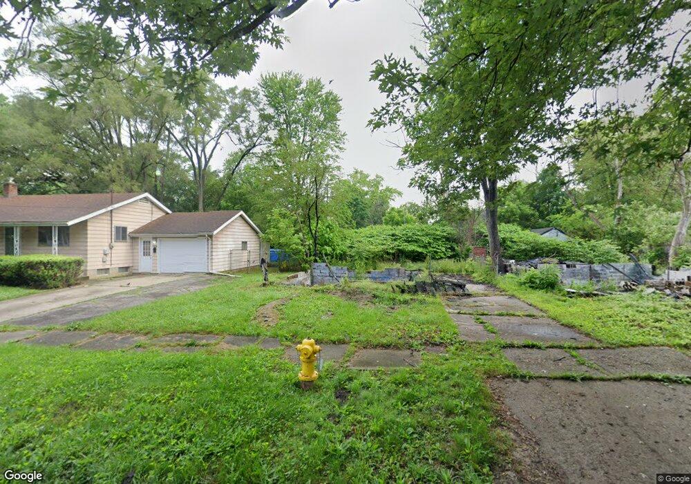
2017 Kentucky Ave Flint, MI 48506
Eastside NeighborhoodEstimated Value: $37,000 - $54,000
3
Beds
1
Bath
936
Sq Ft
$48/Sq Ft
Est. Value
About This Home
This home is located at 2017 Kentucky Ave, Flint, MI 48506 and is currently estimated at $45,194, approximately $48 per square foot. 2017 Kentucky Ave is a home located in Genesee County with nearby schools including Potter School, Flint Cultural Center Academy, and WAY Academy of Flint.
Ownership History
Date
Name
Owned For
Owner Type
Purchase Details
Closed on
Dec 19, 2019
Sold by
Genesee County Treasurer
Bought by
Genesee County Land Bank Authority
Current Estimated Value
Purchase Details
Closed on
Mar 25, 2011
Sold by
Stair Philip G
Bought by
Dean Ernest Marshall
Purchase Details
Closed on
Dec 22, 2010
Sold by
Genesee County Treasurer
Bought by
Genesee County Land Bank
Purchase Details
Closed on
Jun 22, 2006
Sold by
Sterling Imogene and The Imogene Sterling Trust
Bought by
Henry Charles and Henry Rita
Home Financials for this Owner
Home Financials are based on the most recent Mortgage that was taken out on this home.
Original Mortgage
$33,750
Interest Rate
9.7%
Mortgage Type
Purchase Money Mortgage
Create a Home Valuation Report for This Property
The Home Valuation Report is an in-depth analysis detailing your home's value as well as a comparison with similar homes in the area
Home Values in the Area
Average Home Value in this Area
Purchase History
| Date | Buyer | Sale Price | Title Company |
|---|---|---|---|
| Genesee County Land Bank Authority | -- | None Available | |
| Dean Ernest Marshall | -- | None Available | |
| Genesee County Land Bank | -- | None Available | |
| Henry Charles | $37,500 | Great Lakes Title Of Mi |
Source: Public Records
Mortgage History
| Date | Status | Borrower | Loan Amount |
|---|---|---|---|
| Previous Owner | Henry Charles | $33,750 |
Source: Public Records
Tax History Compared to Growth
Tax History
| Year | Tax Paid | Tax Assessment Tax Assessment Total Assessment is a certain percentage of the fair market value that is determined by local assessors to be the total taxable value of land and additions on the property. | Land | Improvement |
|---|---|---|---|---|
| 2025 | -- | $0 | $0 | $0 |
| 2024 | -- | $0 | $0 | $0 |
| 2023 | -- | $0 | $0 | $0 |
| 2022 | $0 | $0 | $0 | $0 |
| 2021 | $0 | $0 | $0 | $0 |
| 2020 | $268 | $0 | $0 | $0 |
| 2019 | $602 | $5,100 | $0 | $0 |
| 2018 | $647 | $6,100 | $0 | $0 |
| 2017 | $807 | $0 | $0 | $0 |
| 2016 | $801 | $0 | $0 | $0 |
| 2015 | -- | $0 | $0 | $0 |
| 2014 | -- | $0 | $0 | $0 |
| 2012 | -- | $11,400 | $0 | $0 |
Source: Public Records
Map
Nearby Homes
- 1318 Cronk Ave
- 1501 Arlington Ave
- 2301 Missouri Ave
- 1510 N Vernon Ave
- 1220 Minnesota Ave
- 1622 Arlington Ave
- 2426 Missouri Ave
- 1644 Pennsylvania Ave
- 2605 Nebraska Ave
- 1605 Kearsley Park Blvd
- 2610 Pennsylvania Ave
- 301 Chandler St
- 1612 Iowa Ave
- 406 S Lynch St
- 1445 Kearsley Park Kearsley Park
- 524 S Lynch St
- 1805 Bennett Ave
- 605 S Lynch St
- 2131 Windemere Ave
- 1814 Mabel Ave
- 2021 Kentucky Ave
- 2013 Kentucky Ave
- 2101 Kentucky Ave
- 2018 Missouri Ave
- 2022 Missouri Ave
- 2014 Missouri Ave
- 2005 Kentucky Ave
- 2105 Kentucky Ave
- 2010 Missouri Ave
- 2102 Missouri Ave
- 2001 Kentucky Ave
- 2006 Missouri Ave
- 2018 Kentucky Ave
- 2106 Missouri Ave
- 2022 Kentucky Ave
- 2014 Kentucky Ave
- 2113 Kentucky Ave
- 2102 Kentucky Ave
- 2010 Kentucky Ave
- 2002 Missouri Ave