Estimated Value: $252,000 - $325,639
About This Home
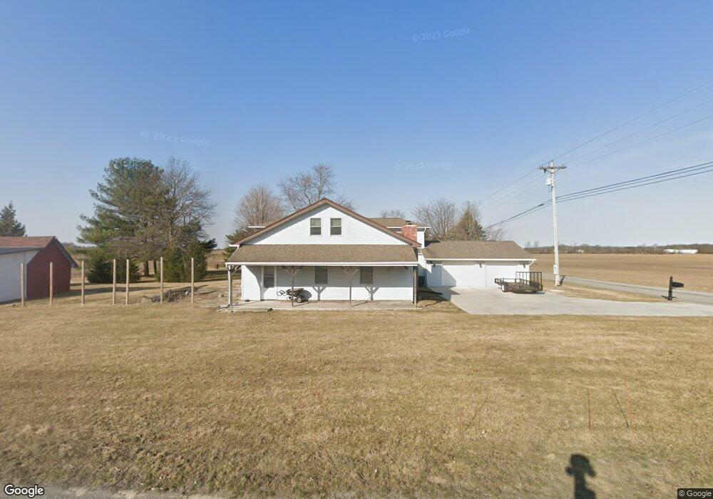
This home is located at 2017 State Route 235, Ada, OH 45810 and is currently estimated at $278,160, approximately $96 per square foot. 2017 State Route 235 is a home with nearby schools including Ada Elementary School and Ada High School.
Ownership History
We collect this data history from publicly available records. To have your information removed, we recommend requesting removal directly through your county’s website.
Purchase Details
Purchase Details
Purchase Details
Purchase History
We collect this data history from publicly available records. To have your information removed, we recommend requesting removal directly through your county’s website.
| Date | Buyer | Sale Price | Title Company |
|---|---|---|---|
| -- | None Available | ||
| $29,000 | None Available | ||
| -- | -- |
Mortgage History
We collect this data history from publicly available records. To have your information removed, we recommend requesting removal directly through your county’s website.
| Date | Status | Borrower | Loan Amount |
|---|---|---|---|
| Closed | $25,000 | ||
| Closed | $54,000 |
Tax History
We collect this data history from publicly available records. To have your information removed, we recommend requesting removal directly through your county’s website.
| Year | Tax Paid | Tax Assessment Tax Assessment Total Assessment is a certain percentage of the fair market value that is determined by local assessors to be the total taxable value of land and additions on the property. | Land | Improvement |
|---|---|---|---|---|
| 2025 | $2,565 | $68,490 | $6,830 | $61,660 |
| 2024 | $2,550 | $68,490 | $6,830 | $61,660 |
| 2023 | $2,530 | $68,490 | $6,830 | $61,660 |
| 2022 | $2,279 | $53,520 | $3,440 | $50,080 |
| 2021 | $2,511 | $53,520 | $3,440 | $50,080 |
| 2020 | $2,544 | $53,520 | $3,440 | $50,080 |
| 2019 | $2,235 | $47,610 | $3,280 | $44,330 |
| 2018 | $2,185 | $47,610 | $3,280 | $44,330 |
| 2017 | $1,848 | $47,610 | $3,280 | $44,330 |
| 2016 | $1,563 | $36,720 | $2,870 | $33,850 |
| 2015 | $1,531 | $36,720 | $2,870 | $33,850 |
| 2014 | $1,119 | $26,760 | $2,870 | $23,890 |
| 2013 | $695 | $15,470 | $2,870 | $12,600 |
Map
- 746 N Main St Unit 61
- 746 N Main St Unit 63
- 746 N Main St Unit 9
- 746 N Main St Unit 70
- 746 N Main St Unit 8
- 746 N Main St Unit 39
- 715 N Johnson St
- 714 Autumn Dr
- 549 N Gilbert St
- 503 E North Ave
- 423 N Johnson St
- 425 Liberty St
- 406 N Main St
- 128 E Montford Ave
- 210 W Montford Ave
- 210 N Gilbert St
- 220 E Lincoln Ave
- 447 State Route 235
- 547 E Lincoln Ave Unit Rear
- 407 Ream St
- 2017 Sr
- 2972 Tr 30
- 2910 Tr 30
- 1915 State Route 235
- 2892 Township Road 30
- 2107 State Route 235
- 2892 Tr
- 1915 Ohio 235
- 1954 State Route 235
- 2884 Tr
- 2014 Sr
- 1840 State Route
- 1840 State Route 235
- 1954 Sr
- 2120 State Route 235
- 1768 State Route 235
- 2305 State Route 235
- 3261 Township Road 30
- 1733 State Route 235
- 2646 Tr
Ask me questions while you tour the home.