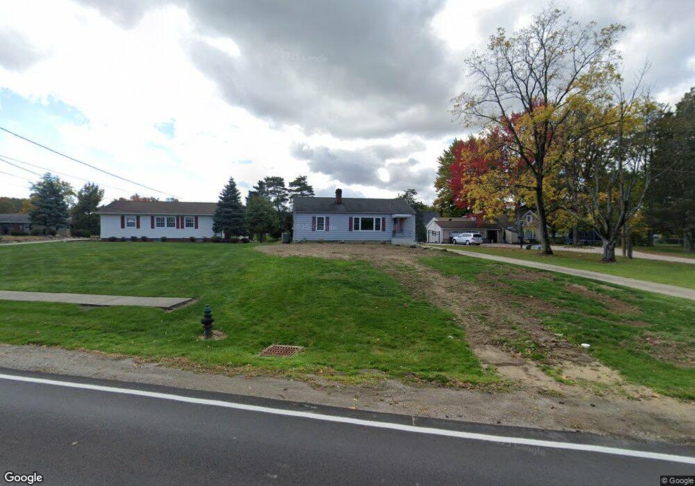
20171 Westwood Dr Strongsville, OH 44149
Estimated Value: $206,000 - $231,917
3
Beds
1
Bath
984
Sq Ft
$226/Sq Ft
Est. Value
About This Home
This home is located at 20171 Westwood Dr, Strongsville, OH 44149 and is currently estimated at $221,979, approximately $225 per square foot. 20171 Westwood Dr is a home located in Cuyahoga County with nearby schools including Strongsville High School, Strongsville Academy, and Sts Joseph & John Interparochial School.
Ownership History
Date
Name
Owned For
Owner Type
Purchase Details
Closed on
Jan 11, 2005
Sold by
Rienerth Thomas J
Bought by
Crossroads 2000 Ltd
Current Estimated Value
Purchase Details
Closed on
Feb 19, 2003
Sold by
Rienerth Thomas J
Bought by
Rienerth Thomas J and Thomas J Rienerth Trust
Purchase Details
Closed on
Oct 27, 1986
Sold by
Slys Janet A
Bought by
Rienerth Thomas J
Purchase Details
Closed on
Jun 12, 1985
Sold by
Gordon V Clement
Bought by
Slys Janet A
Purchase Details
Closed on
Dec 26, 1979
Sold by
Clement Gordon and Clement Lucy A
Bought by
Gordon V Clement
Purchase Details
Closed on
Jan 1, 1975
Bought by
Clement Gordon and Clement Lucy A
Create a Home Valuation Report for This Property
The Home Valuation Report is an in-depth analysis detailing your home's value as well as a comparison with similar homes in the area
Home Values in the Area
Average Home Value in this Area
Purchase History
| Date | Buyer | Sale Price | Title Company |
|---|---|---|---|
| Crossroads 2000 Ltd | $20,000 | Midland Title Agency | |
| Rienerth Thomas J | -- | -- | |
| Rienerth Thomas J | $65,500 | -- | |
| Slys Janet A | -- | -- | |
| Gordon V Clement | -- | -- | |
| Clement Gordon | -- | -- |
Source: Public Records
Tax History Compared to Growth
Tax History
| Year | Tax Paid | Tax Assessment Tax Assessment Total Assessment is a certain percentage of the fair market value that is determined by local assessors to be the total taxable value of land and additions on the property. | Land | Improvement |
|---|---|---|---|---|
| 2024 | $2,801 | $69,440 | $8,155 | $61,285 |
| 2023 | $2,781 | $53,590 | $8,720 | $44,870 |
| 2022 | $2,787 | $53,590 | $8,720 | $44,870 |
| 2021 | $2,765 | $53,590 | $8,720 | $44,870 |
| 2020 | $2,452 | $43,930 | $7,140 | $36,790 |
| 2019 | $2,380 | $125,500 | $20,400 | $105,100 |
| 2018 | $2,063 | $43,930 | $7,140 | $36,790 |
| 2017 | $2,002 | $38,930 | $5,640 | $33,290 |
| 2016 | $1,986 | $38,930 | $5,640 | $33,290 |
| 2015 | $1,939 | $38,930 | $5,640 | $33,290 |
| 2014 | $1,939 | $37,800 | $5,460 | $32,340 |
Source: Public Records
Map
Nearby Homes
- 13236 Tomson Dr
- 12651 Alameda Dr
- 12694 Ionia Ct
- 12647 Edgepark Cir
- 12385 Corinth Ct
- 12539 Olympus Way
- 13066 Olympus Way
- 13156 Olympus Way
- 13099 Olympus Way
- 14112 Settlers Way
- 19620 Porters Ln Unit 15F
- 20078 Trapper Trail
- 22125 Olde Creek Trail
- 19160 Wheelers Ln
- 14400 Prospect Rd
- 11179 Fawn Meadow Ln
- 19997 Idlewood Trail
- 22235 North Trail
- 20050 Idlewood Trail
- 11432 Pearl Rd
- 20107 Westwood Dr
- 20179 Westwood Dr
- 12703 Edgebrook Dr
- 20239 Westwood Dr
- 20099 Westwood Dr
- 20214 Carlyle Dr
- 20242 Carlyle Dr
- 20186 Carlyle Dr
- 20136 Westwood Dr
- 20270 Carlyle Dr
- 20158 Carlyle Dr
- 20047 Westwood Dr
- 20247 Westwood Dr
- 20170 Westwood Dr
- 20132 Carlyle Dr
- 20278 Carlyle Dr
- 20301 Westwood Dr
- 20306 Carlyle Dr
- 20208 Westwood Dr
- 20035 Westwood Dr