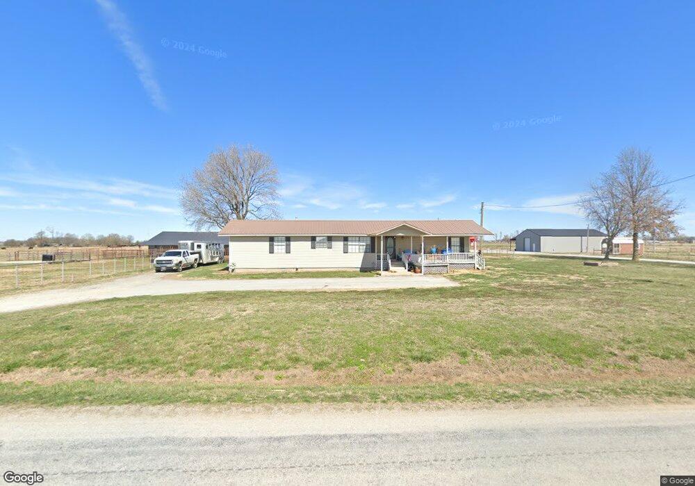
20178 Bill Young Rd Siloam Springs, AR 72761
Estimated Value: $314,000 - $1,213,585
--
Bed
1
Bath
1,931
Sq Ft
$352/Sq Ft
Est. Value
About This Home
This home is located at 20178 Bill Young Rd, Siloam Springs, AR 72761 and is currently estimated at $679,146, approximately $351 per square foot. 20178 Bill Young Rd is a home located in Benton County with nearby schools including Gentry Intermediate School, Gentry Primary School, and Gentry Middle School.
Ownership History
Date
Name
Owned For
Owner Type
Purchase Details
Closed on
Apr 15, 2020
Sold by
Miller Jeremiah and Miller Deana
Bought by
L Weston Limited Liability Company
Current Estimated Value
Home Financials for this Owner
Home Financials are based on the most recent Mortgage that was taken out on this home.
Original Mortgage
$520,000
Outstanding Balance
$410,180
Interest Rate
3.2%
Mortgage Type
Future Advance Clause Open End Mortgage
Estimated Equity
$268,966
Purchase Details
Closed on
Jan 20, 2016
Sold by
Mcreynolds James Brian and Mcreynolds Janie
Bought by
Miller Jeremiah and Miller Deana
Home Financials for this Owner
Home Financials are based on the most recent Mortgage that was taken out on this home.
Original Mortgage
$142,500
Interest Rate
3.99%
Mortgage Type
Future Advance Clause Open End Mortgage
Purchase Details
Closed on
Apr 10, 1986
Bought by
Mcreynolds J
Create a Home Valuation Report for This Property
The Home Valuation Report is an in-depth analysis detailing your home's value as well as a comparison with similar homes in the area
Home Values in the Area
Average Home Value in this Area
Purchase History
| Date | Buyer | Sale Price | Title Company |
|---|---|---|---|
| L Weston Limited Liability Company | $650,000 | Waco Title Company | |
| Miller Jeremiah | $285,000 | Waco Title Company | |
| Mcreynolds J | -- | -- |
Source: Public Records
Mortgage History
| Date | Status | Borrower | Loan Amount |
|---|---|---|---|
| Open | L Weston Limited Liability Company | $520,000 | |
| Previous Owner | Miller Jeremiah | $142,500 |
Source: Public Records
Tax History Compared to Growth
Tax History
| Year | Tax Paid | Tax Assessment Tax Assessment Total Assessment is a certain percentage of the fair market value that is determined by local assessors to be the total taxable value of land and additions on the property. | Land | Improvement |
|---|---|---|---|---|
| 2025 | $1,592 | $31,089 | $6,887 | $24,202 |
| 2024 | $1,554 | $31,089 | $6,887 | $24,202 |
| 2023 | $1,559 | $31,187 | $4,790 | $26,397 |
| 2022 | $1,659 | $31,187 | $4,790 | $26,397 |
| 2021 | $1,459 | $70,700 | $4,790 | $65,910 |
| 2020 | $3,228 | $60,800 | $3,450 | $57,350 |
| 2019 | $3,228 | $60,800 | $3,450 | $57,350 |
| 2018 | $3,228 | $60,800 | $3,450 | $57,350 |
| 2017 | $1,682 | $60,800 | $3,450 | $57,350 |
| 2016 | $1,682 | $61,380 | $3,450 | $57,930 |
| 2015 | $1,682 | $33,630 | $2,960 | $30,670 |
| 2014 | $1,682 | $33,630 | $2,960 | $30,670 |
Source: Public Records
Map
Nearby Homes
- 0 Bill Young Rd Unit 1323460
- 0 Bill Young Rd Unit 21090656
- 14987 S Highway 59
- 15564 Airport Rd
- 3605 N Marian St
- 20597 Shady Grove Rd
- 19100 Bill Young Rd
- 21036 Richard Ct
- 20944 Shady Grove Rd
- 13992 Cozy Corners Rd
- TBD O'Neal Rd
- 13517 Old Highway 59
- 2.8 Acres Southern View
- 9005 E Covington Rd
- 8006 David Dr
- 7004 David Dr
- 0 Tbd Davidson Rd
- 7000 E Sugarloaf St
- 0 E Sugarloaf St
- WARREN Plan at Hillcrest
- 20178 Bill Young Rd
- 0 Bill Young Rd Unit 2427378
- 0 Bill Young Rd Unit 1245790
- 0 Bill Young Rd Unit 610085
- 0 Bill Young Rd Unit 642547
- 0 Bill Young Rd Unit 1122169
- 0 Bill Young Rd Unit 1215677
- TBD Bill Young Rd
- 20303 Bill Young Rd
- tbd Russell Rd
- D Bill Young Rd
- C Bill Young Rd
- B Bill Young Rd
- A Bill Young Rd
- 14888 Airport Rd
- Bill Young Rd & Airp Bill Yound Rd Russel
- Airport Rd & Bill Yo Bill Yound Rd Russel
- 14948 Airport Rd
- ?? Bill Young Rd
- 0 Xxxxx Bill Young Rd Unit 710171