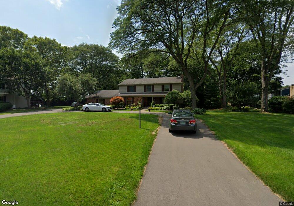
20187 Evans Ct Beverly Hills, MI 48025
Estimated Value: $705,307 - $899,000
5
Beds
4
Baths
3,235
Sq Ft
$254/Sq Ft
Est. Value
About This Home
This home is located at 20187 Evans Ct, Beverly Hills, MI 48025 and is currently estimated at $822,577, approximately $254 per square foot. 20187 Evans Ct is a home located in Oakland County with nearby schools including Wylie E. Groves High School, Beverly Elementary School, and Berkshire Middle School.
Ownership History
Date
Name
Owned For
Owner Type
Purchase Details
Closed on
Apr 29, 2008
Sold by
Hoover Randall A and Hoover Jennifer A
Bought by
Wright Douglas and Shannon Maureen
Current Estimated Value
Home Financials for this Owner
Home Financials are based on the most recent Mortgage that was taken out on this home.
Original Mortgage
$235,000
Outstanding Balance
$146,830
Interest Rate
5.88%
Mortgage Type
Purchase Money Mortgage
Estimated Equity
$675,747
Create a Home Valuation Report for This Property
The Home Valuation Report is an in-depth analysis detailing your home's value as well as a comparison with similar homes in the area
Home Values in the Area
Average Home Value in this Area
Purchase History
| Date | Buyer | Sale Price | Title Company |
|---|---|---|---|
| Wright Douglas | $460,000 | Title Source Inc |
Source: Public Records
Mortgage History
| Date | Status | Borrower | Loan Amount |
|---|---|---|---|
| Open | Wright Douglas | $235,000 |
Source: Public Records
Tax History
| Year | Tax Paid | Tax Assessment Tax Assessment Total Assessment is a certain percentage of the fair market value that is determined by local assessors to be the total taxable value of land and additions on the property. | Land | Improvement |
|---|---|---|---|---|
| 2025 | $5,322 | $334,940 | $0 | $0 |
| 2024 | $7,070 | $318,530 | $0 | $0 |
| 2023 | $6,783 | $292,440 | $0 | $0 |
| 2022 | $7,357 | $274,520 | $0 | $0 |
| 2021 | $7,417 | $261,650 | $0 | $0 |
| 2020 | $6,214 | $266,720 | $0 | $0 |
| 2019 | $4,909 | $258,830 | $0 | $0 |
| 2018 | $7,051 | $235,870 | $0 | $0 |
| 2017 | $7,022 | $235,870 | $0 | $0 |
| 2016 | $7,048 | $226,300 | $0 | $0 |
| 2015 | -- | $210,020 | $0 | $0 |
| 2014 | -- | $197,060 | $0 | $0 |
| 2011 | -- | $152,610 | $0 | $0 |
Source: Public Records
Map
Nearby Homes
- 19710 W 13 Mile Rd Unit 107
- 19710 W 13 Mile Rd Unit 101
- 19710 W 13 Mile Rd Unit 108
- 19710 W 13 Mile Rd Unit 102
- 19710 W 13 Mile Rd Unit 210
- 19710 W 13 Mile Rd Unit 105
- 19710 W 13 Mile Rd Unit 111
- 19710 W 13 Mile Rd Unit 201
- 31065 Tremont Ln
- 31018 Pickwick Ln
- 19332 Beverly Rd
- 19245 Eldridge Ln
- 32700 Evergreen Rd
- 18910 Devonshire St
- 20204 Beechaven St
- 10 Riverbank Dr
- 19771 Hickory Leaf St
- 18930 Hillcrest St
- 31130 Lahser Rd
- 31111 Lahser Rd
- 20169 Evans Ct
- 20225 Ronsdale Dr
- 20205 Ronsdale Dr Unit Bldg-Unit
- 20205 Ronsdale Dr
- 20267 Douglas Ct
- 20245 Ronsdale Dr
- 20153 Evans Ct
- 20081 Ronsdale Dr
- 20121 Evans Ct
- 20137 Evans Ct
- 20279 Douglas Ct
- 20220 Ronsdale Dr
- 20069 Ronsdale Dr
- 20200 Ronsdale Dr
- 20242 Ronsdale Dr
- 20295 Douglas Ct
- 20090 Ronsdale Dr
- 20264 Ronsdale Dr
- 31575 Evergreen Rd
- 20285 Douglas Ct
Your Personal Tour Guide
Ask me questions while you tour the home.