2019 Morse Ave Des Plaines, IL 60018
Des Plaines AreaEstimated Value: $402,000 - $453,000
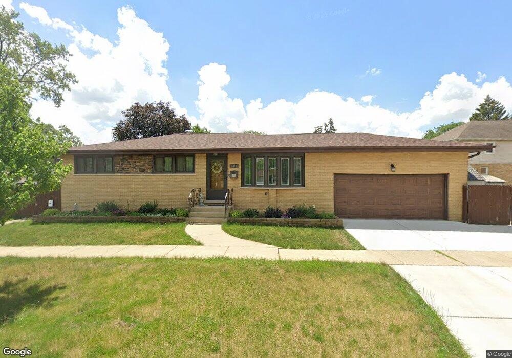
About This Home
This home is located at 2019 Morse Ave, Des Plaines, IL 60018 and is currently estimated at $435,287, approximately $298 per square foot. 2019 Morse Ave is a home located in Cook County with nearby schools including Orchard Place Elementary School, Algonquin Middle School, and Maine West High School.
Ownership History
We collect this data history from publicly available records. To have your information removed, we recommend requesting removal directly through your county’s website.
Purchase Details
Home Financials for this Owner
Home Financials are based on the most recent Mortgage that was taken out on this home.Purchase Details
Home Values in the Area
Average Home Value in this Area
Purchase History
We collect this data history from publicly available records. To have your information removed, we recommend requesting removal directly through your county’s website.
| Date | Buyer | Sale Price | Title Company |
|---|---|---|---|
| $123,500 | First American Title Ins Co | ||
| -- | -- |
Mortgage History
We collect this data history from publicly available records. To have your information removed, we recommend requesting removal directly through your county’s website.
| Date | Status | Borrower | Loan Amount |
|---|---|---|---|
| Open | $54,000 | ||
| Open | $133,309 |
Tax History
We collect this data history from publicly available records. To have your information removed, we recommend requesting removal directly through your county’s website.
| Year | Tax Paid | Tax Assessment Tax Assessment Total Assessment is a certain percentage of the fair market value that is determined by local assessors to be the total taxable value of land and additions on the property. | Land | Improvement |
|---|---|---|---|---|
| 2025 | $6,772 | $38,000 | $7,072 | $30,928 |
| 2024 | $6,772 | $31,710 | $5,894 | $25,816 |
| 2023 | $6,582 | $29,001 | $5,894 | $23,107 |
| 2022 | $6,582 | $29,001 | $5,894 | $23,107 |
| 2021 | $4,623 | $18,370 | $4,911 | $13,459 |
| 2020 | $4,614 | $18,370 | $4,911 | $13,459 |
| 2019 | $4,632 | $20,641 | $4,911 | $15,730 |
| 2018 | $5,547 | $21,982 | $4,321 | $17,661 |
| 2017 | $5,466 | $21,982 | $4,321 | $17,661 |
| 2016 | $5,414 | $21,982 | $4,321 | $17,661 |
| 2015 | $5,367 | $20,377 | $3,732 | $16,645 |
| 2014 | $5,270 | $20,377 | $3,732 | $16,645 |
| 2013 | $5,121 | $20,377 | $3,732 | $16,645 |
Map
- 2646 Maple St
- 2993 Curtis St Unit D46
- 2993 Curtis St Unit 69
- 1757 Farwell Ave
- 1753 Lunt Ave
- 1730 Lunt Ave
- 1678 Farwell Ave
- 1988 E Touhy Ave
- 1738 Lunt Ave
- 1972 Fargo Ave
- 2600 Windsor Mall Unit 2B
- 2600 Windsor Mall Unit 2E
- 9608 W Higgins Rd Unit 2C
- 500 Thames Pkwy Unit 1F
- 6204 N Emerson St
- 201 Thames Pkwy Unit 3G
- 400 Ascot Dr Unit 3E
- 400 Ascot Dr Unit 2L
- 2400 Archbury Ln Unit 2
- 2420 W Talcott Rd Unit 211
- 2727 S Scott St
- 2715 S Scott St
- 2735 S Scott St
- 2745 S Scott St
- 2709 S Scott St
- 2726 Joseph Ave
- 2734 Joseph Ave
- 2716 Joseph Ave
- 2740 Joseph Ave
- 2753 S Scott St
- 2746 Joseph Ave
- 2708 Joseph Ave
- 2759 S Scott St
- 2685 S Scott St
- 2010 Morse Ave
- 2728 S Scott St
- 2720 S Scott St
- 2738 S Scott St
- 2710 S Scott St
- 2754 Joseph Ave
Ask me questions while you tour the home.