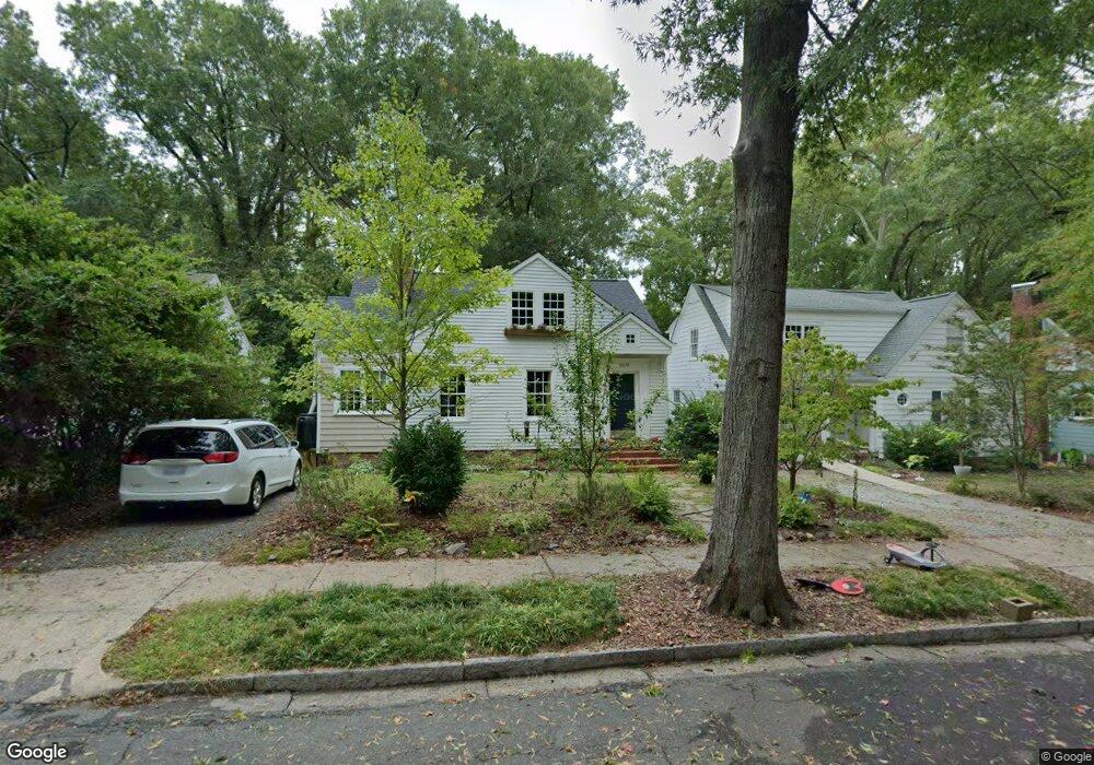
2019 Pershing St Durham, NC 27705
Watts Hospital-Hillandale NeighborhoodEstimated Value: $584,000 - $628,000
4
Beds
2
Baths
1,371
Sq Ft
$445/Sq Ft
Est. Value
About This Home
This home is located at 2019 Pershing St, Durham, NC 27705 and is currently estimated at $609,932, approximately $444 per square foot. 2019 Pershing St is a home located in Durham County with nearby schools including E K Powe Elementary, W.G. Pearson Elementary School, and Brogden Middle.
Ownership History
Date
Name
Owned For
Owner Type
Purchase Details
Closed on
Jul 30, 2014
Sold by
Stargel Wilford Wayne and Stargel Virginia M
Bought by
Kenenitz Gregory and Pardue Britney
Current Estimated Value
Home Financials for this Owner
Home Financials are based on the most recent Mortgage that was taken out on this home.
Original Mortgage
$220,000
Outstanding Balance
$168,561
Interest Rate
4.24%
Mortgage Type
New Conventional
Estimated Equity
$441,371
Create a Home Valuation Report for This Property
The Home Valuation Report is an in-depth analysis detailing your home's value as well as a comparison with similar homes in the area
Home Values in the Area
Average Home Value in this Area
Purchase History
| Date | Buyer | Sale Price | Title Company |
|---|---|---|---|
| Kenenitz Gregory | $277,500 | None Available |
Source: Public Records
Mortgage History
| Date | Status | Borrower | Loan Amount |
|---|---|---|---|
| Open | Kenenitz Gregory | $220,000 |
Source: Public Records
Tax History
| Year | Tax Paid | Tax Assessment Tax Assessment Total Assessment is a certain percentage of the fair market value that is determined by local assessors to be the total taxable value of land and additions on the property. | Land | Improvement |
|---|---|---|---|---|
| 2025 | $5,404 | $545,109 | $307,125 | $237,984 |
| 2024 | $4,119 | $295,317 | $105,390 | $189,927 |
| 2023 | $3,868 | $295,317 | $105,390 | $189,927 |
| 2022 | $3,780 | $295,317 | $105,390 | $189,927 |
| 2021 | $3,762 | $295,317 | $105,390 | $189,927 |
| 2020 | $3,673 | $295,317 | $105,390 | $189,927 |
| 2019 | $3,673 | $295,317 | $105,390 | $189,927 |
| 2018 | $4,426 | $326,265 | $52,695 | $273,570 |
| 2017 | $4,393 | $326,265 | $52,695 | $273,570 |
| 2016 | $4,245 | $326,265 | $52,695 | $273,570 |
| 2015 | $2,349 | $169,670 | $41,509 | $128,161 |
| 2014 | -- | $162,154 | $41,509 | $120,645 |
Source: Public Records
Map
Nearby Homes
- 1401 Maryland Ave
- 2111 Pershing St
- 2116 Pershing St
- 2101 Sunset Ave
- 1804 Sunset Ave
- 1106 9th St
- 2305 Sprunt Ave
- 1007 Virgie St
- 1409 Sedgefield St
- 1308 Sedgefield St Unit A
- 2303 Englewood Ave
- 919 Sedgefield St
- 1811 Forest Rd
- 1801 Forest Rd
- 2207 Edwin Ave
- 1820 Forest Rd
- 1708 Forest Rd
- 1019 Sedgefield St
- 1406 W Club Blvd Unit A&B
- 914 Rosehill Ave
- 2017 Pershing St
- 2021 Pershing St
- 2015 Pershing St
- 2023 Pershing St
- 2013 Pershing St
- 2025 Pershing St
- 2018 Wilson St
- 2020 Wilson St
- 2016 Wilson St
- 2014 Wilson St
- 2022 Wilson St
- 2011 Pershing St
- 2027 Pershing St
- 2018 Pershing St
- 2020 Pershing St
- 2022 Pershing St
- 2016 Pershing St
- 2024 Pershing St
- 2016 & 201 Pershing St
- 2016 & 2014 Pershing St
Your Personal Tour Guide
Ask me questions while you tour the home.