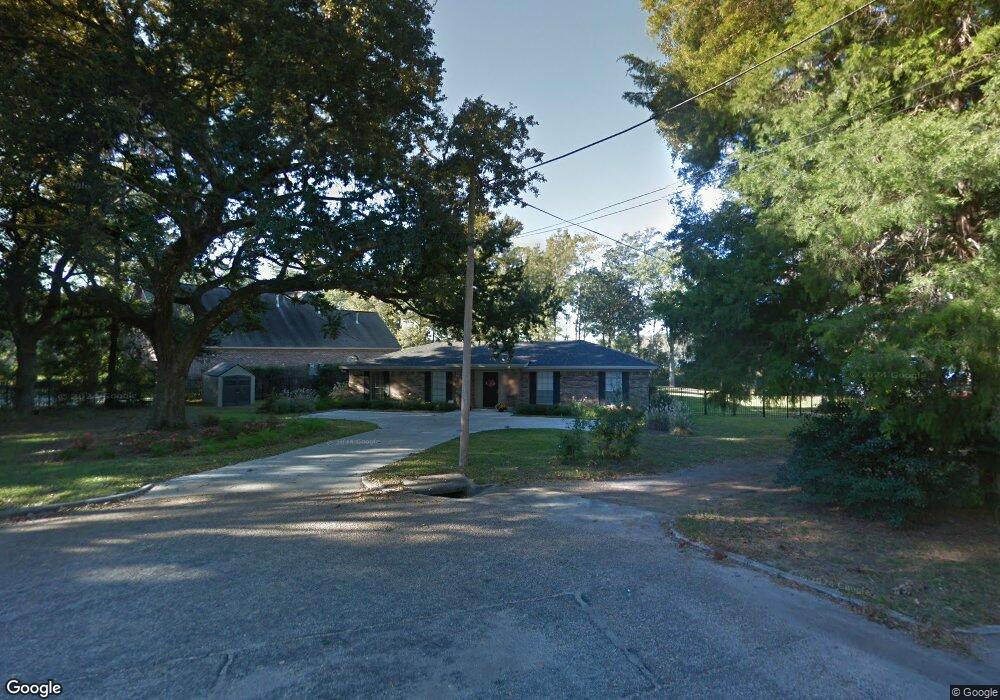
2019 Robin Hood Dr Mobile, AL 36605
Neshota NeighborhoodEstimated Value: $168,000 - $752,000
3
Beds
2
Baths
1,638
Sq Ft
$213/Sq Ft
Est. Value
About This Home
This home is located at 2019 Robin Hood Dr, Mobile, AL 36605 and is currently estimated at $348,349, approximately $212 per square foot. 2019 Robin Hood Dr is a home located in Mobile County with nearby schools including Dr. Robert W. Gilliard Elementary School and Ben C Rain High School.
Ownership History
Date
Name
Owned For
Owner Type
Purchase Details
Closed on
Aug 4, 2009
Sold by
Sanders Bradley R and Sanders Katherine Olts
Bought by
Sanders Katherine Olts
Current Estimated Value
Purchase Details
Closed on
Apr 13, 2009
Sold by
Sullivan Richard A and Sullivan Lisa W
Bought by
Sanders Bradley R and Sanders Katherine O
Purchase Details
Closed on
May 30, 2007
Sold by
Mccarron Jessie C
Bought by
Sullivan Richard A and Sullivan Lisa
Purchase Details
Closed on
Jan 5, 1999
Sold by
Mccarron Jessie C
Bought by
Mccarron Jessie C
Create a Home Valuation Report for This Property
The Home Valuation Report is an in-depth analysis detailing your home's value as well as a comparison with similar homes in the area
Home Values in the Area
Average Home Value in this Area
Purchase History
| Date | Buyer | Sale Price | Title Company |
|---|---|---|---|
| Sanders Katherine Olts | -- | None Available | |
| Sanders Bradley R | -- | None Available | |
| Sullivan Richard A | $190,000 | Gtc | |
| Mccarron Jessie C | -- | -- |
Source: Public Records
Tax History Compared to Growth
Tax History
| Year | Tax Paid | Tax Assessment Tax Assessment Total Assessment is a certain percentage of the fair market value that is determined by local assessors to be the total taxable value of land and additions on the property. | Land | Improvement |
|---|---|---|---|---|
| 2024 | $1,228 | $36,840 | $15,400 | $21,440 |
| 2023 | $2,447 | $38,540 | $15,680 | $22,860 |
| 2022 | $2,341 | $36,860 | $14,000 | $22,860 |
| 2021 | $2,209 | $34,780 | $14,000 | $20,780 |
| 2020 | $2,209 | $34,780 | $14,000 | $20,780 |
| 2019 | $2,101 | $33,080 | $14,000 | $19,080 |
| 2018 | $2,101 | $33,080 | $0 | $0 |
| 2017 | $2,079 | $32,740 | $0 | $0 |
| 2016 | $2,051 | $32,300 | $0 | $0 |
| 2013 | $1,979 | $30,740 | $0 | $0 |
Source: Public Records
Map
Nearby Homes
- 2637 Robin Hood Dr
- 1825 S Nottingham Dr Unit 3
- 2100 Allen Ct
- 1953 Brill Rd
- 2204 David Dr
- 0 Riverside Dr Unit 7530346
- 2256 W Hillwood Dr
- 2204 Weaver Rd
- 1909 Riverside Dr
- 2753 S Lartigue Ave
- 1916 Gill Rd
- 2130 Barron Place
- 326 Riverbend Dr Unit 326
- 3035 Dauphin Island Pkwy
- 319 Riverbend Dr Unit 319
- 201 Riverbend Dr
- 301 Riverbend Dr
- 221 Riverbend Dr Unit 221
- 2000 Riverview Ave
- 1550 S Lartigue Ave
- 2665 Robin Hood Dr
- 2022 Robin Hood Dr
- 2018 Robin Hood Dr
- 2012 Robin Hood Dr
- 2657 Robin Hood Dr
- 2015 Archer Ln
- 2023 Archer Ln
- 2011 Archer Ln
- 2006 Robin Hood Dr
- 2649 Robin Hood Dr
- 2649 Robin Hood Dr Unit 116
- 2007 Archer Ln
- 2016 Archer Ln
- 2000 Robin Hood Dr Unit 2
- 2012 Archer Ln
- 2005 Archer Ln
- 2008 Archer Ln
- 2001 Archer Ln
- 2530 S Daniels Rd
- 2528 S Daniels Rd