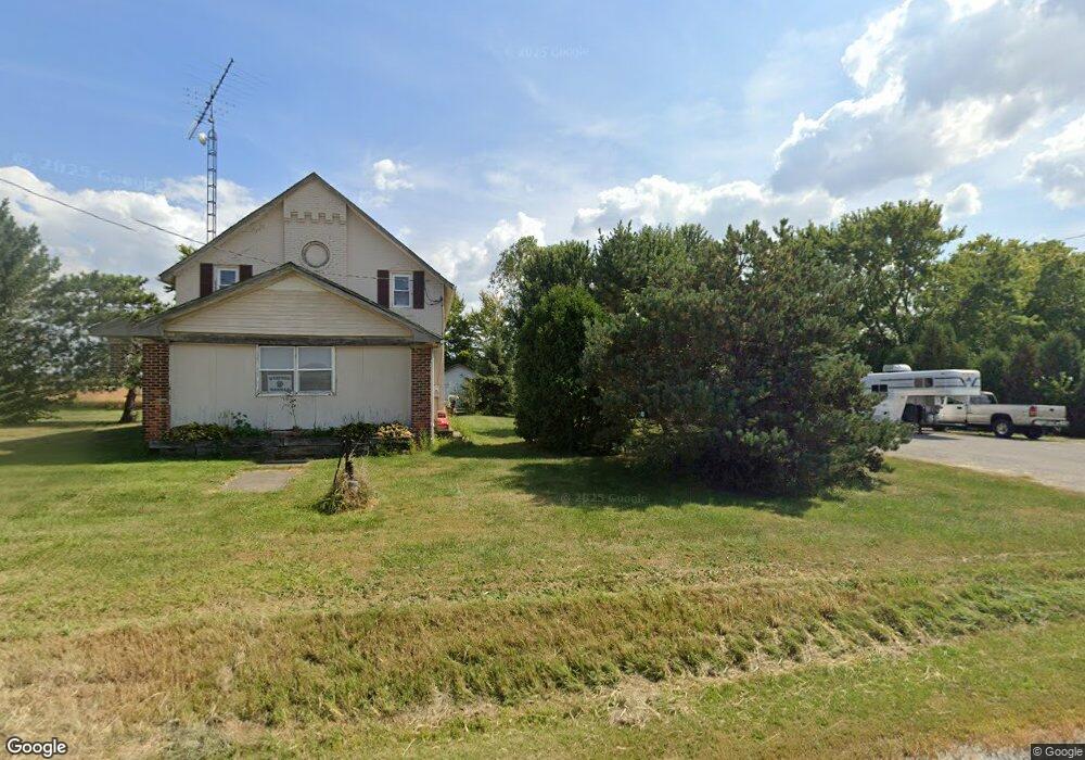
2019 State Route 98 Bucyrus, OH 44820
Estimated Value: $130,000 - $225,000
3
Beds
1
Bath
936
Sq Ft
$183/Sq Ft
Est. Value
About This Home
This home is located at 2019 State Route 98, Bucyrus, OH 44820 and is currently estimated at $171,481, approximately $183 per square foot. 2019 State Route 98 is a home located in Crawford County with nearby schools including Wynford Elementary School, Wynford High School, and CENTER FOR AUTISM / DYSLEXIA - BUCYRUS.
Ownership History
Date
Name
Owned For
Owner Type
Purchase Details
Closed on
Dec 1, 2014
Sold by
Pennymac Corp
Bought by
Pennington Michael
Current Estimated Value
Home Financials for this Owner
Home Financials are based on the most recent Mortgage that was taken out on this home.
Original Mortgage
$25,600
Outstanding Balance
$8,855
Interest Rate
3.97%
Mortgage Type
Purchase Money Mortgage
Estimated Equity
$162,626
Purchase Details
Closed on
Nov 14, 2004
Bought by
Pennymac Corp
Create a Home Valuation Report for This Property
The Home Valuation Report is an in-depth analysis detailing your home's value as well as a comparison with similar homes in the area
Home Values in the Area
Average Home Value in this Area
Purchase History
| Date | Buyer | Sale Price | Title Company |
|---|---|---|---|
| Pennington Michael | $32,000 | Acs Title Bucyrus | |
| Pennymac Corp | $32,000 | -- |
Source: Public Records
Mortgage History
| Date | Status | Borrower | Loan Amount |
|---|---|---|---|
| Open | Pennington Michael | $25,600 |
Source: Public Records
Tax History Compared to Growth
Tax History
| Year | Tax Paid | Tax Assessment Tax Assessment Total Assessment is a certain percentage of the fair market value that is determined by local assessors to be the total taxable value of land and additions on the property. | Land | Improvement |
|---|---|---|---|---|
| 2024 | $1,408 | $37,160 | $4,230 | $32,930 |
| 2023 | $1,408 | $24,490 | $3,470 | $21,020 |
| 2022 | $1,116 | $24,490 | $3,470 | $21,020 |
| 2021 | $1,197 | $24,490 | $3,470 | $21,020 |
| 2020 | $861 | $19,020 | $3,470 | $15,550 |
| 2019 | $886 | $19,020 | $3,470 | $15,550 |
| 2018 | $906 | $19,020 | $3,470 | $15,550 |
| 2017 | $959 | $20,450 | $3,470 | $16,980 |
| 2016 | $802 | $20,450 | $3,470 | $16,980 |
| 2015 | $814 | $20,450 | $3,470 | $16,980 |
| 2014 | $942 | $21,720 | $3,470 | $18,250 |
| 2013 | $942 | $21,720 | $3,470 | $18,250 |
Source: Public Records
Map
Nearby Homes
- 182 Williams St
- 1315 Lynne Ave
- 452 Pleasant Ln
- 1211 S Sandusky Ave
- 0 Lynne Ave
- 1123 Hillcrest Dr
- 1145 Lynne Ave
- 1149 Farmview Dr
- 1021 S Sandusky Ave
- 1112 Hillcrest Dr
- 318 Charlotte St
- 900 S Spring St
- 2440 Wyandot Rd
- 419 Short St
- 275 Brentwood St
- 1465 Oakridge Dr
- 130 Brentwood St
- 708 S Sandusky Ave
- 948 S Highland Ave
- 325 W Liberty St
- 2006 State Route 98
- 2711 Mount Zion Rd
- 2088 State Route 98
- 2061 State Route 98
- 2096 State Route 98
- 2659 Mount Zion Rd
- 2835 Mount Zion Rd
- 000 Mount Zion Rd
- 2108 State Route 98
- 2130 State Route 98
- 2140 State Route 98
- 2148 State Route 98
- 2156 State Route 98
- 2156 State Route 98
- 2572 Mount Zion Rd
- 1786 Street
- 2543 Mount Zion Rd
- 2216 State Route 98
- 1801 State Route 98
- 2953 Mount Zion Rd