Estimated Value: $822,000 - $957,000
6
Beds
4
Baths
4,027
Sq Ft
$222/Sq Ft
Est. Value
About This Home
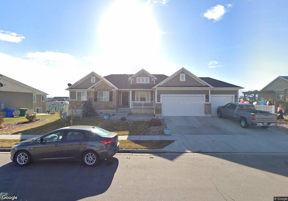
This home is located at 2019 W 450 N, Lehi, UT 84043 and is currently estimated at $892,446, approximately $221 per square foot. 2019 W 450 N is a home located in Utah County with nearby schools including River Rock Elementary, Willowcreek Middle School, and Lehi High School.
Ownership History
Date
Name
Owned For
Owner Type
Purchase Details
Closed on
Apr 20, 2017
Sold by
Worthington Josh T and Worthington Samantha Dil Worth
Bought by
Johnson Doug A and Hansen Tamila
Current Estimated Value
Purchase Details
Closed on
Feb 26, 2014
Sold by
Worthington Josh T
Bought by
Worthington Josh T and Worthington Samantha Dilworth
Home Financials for this Owner
Home Financials are based on the most recent Mortgage that was taken out on this home.
Original Mortgage
$372,841
Interest Rate
4.38%
Mortgage Type
New Conventional
Create a Home Valuation Report for This Property
The Home Valuation Report is an in-depth analysis detailing your home's value as well as a comparison with similar homes in the area
Home Values in the Area
Average Home Value in this Area
Purchase History
| Date | Buyer | Sale Price | Title Company |
|---|---|---|---|
| Johnson Doug A | -- | 1St Liberty Title Lc | |
| Worthington Josh T | -- | Cottonwood Title Ins Ag | |
| Worthington Josh T | -- | Cottonwood Title Ins Ag | |
| Ivory Homes Ltd | -- | Cottonwood Title Ins Ag |
Source: Public Records
Mortgage History
| Date | Status | Borrower | Loan Amount |
|---|---|---|---|
| Previous Owner | Worthington Josh T | $372,841 |
Source: Public Records
Tax History Compared to Growth
Tax History
| Year | Tax Paid | Tax Assessment Tax Assessment Total Assessment is a certain percentage of the fair market value that is determined by local assessors to be the total taxable value of land and additions on the property. | Land | Improvement |
|---|---|---|---|---|
| 2025 | $3,675 | $463,540 | $283,900 | $558,900 |
| 2024 | $3,675 | $430,045 | $0 | $0 |
| 2023 | $3,434 | $436,315 | $0 | $0 |
| 2022 | $3,444 | $424,270 | $0 | $0 |
| 2021 | $3,107 | $578,700 | $164,300 | $414,400 |
| 2020 | $2,930 | $539,400 | $152,100 | $387,300 |
| 2019 | $2,660 | $509,000 | $152,100 | $356,900 |
| 2018 | $2,469 | $446,700 | $130,400 | $316,300 |
| 2017 | $2,443 | $234,960 | $0 | $0 |
| 2016 | $2,516 | $224,565 | $0 | $0 |
| 2015 | $2,535 | $214,720 | $0 | $0 |
| 2014 | $2,249 | $189,420 | $0 | $0 |
Source: Public Records
Map
Nearby Homes
- 41 N 2150 W
- 2162 W Main St Unit E303
- 2178 W Main St Unit D301
- 373 N Willow Haven Ave
- 122 N 2430 W Unit 1
- 2512 W 610 N Unit 99
- 105 N 2430 W
- The Roslyn Plan at Carla's Cove
- The Tracie Plan at Carla's Cove
- The Brooke Plan at Carla's Cove
- The Jackie Plan at Carla's Cove
- 131 S 1900 W Unit 2
- 202 S 2035 W
- 210 S Tamarak Cir
- 1784 W Grays Place
- 1743 W Grays Place
- 161 S 1475 W
- 1127 N 1500 W
- 1032 Titan Dr
- 1302 N 2450 W