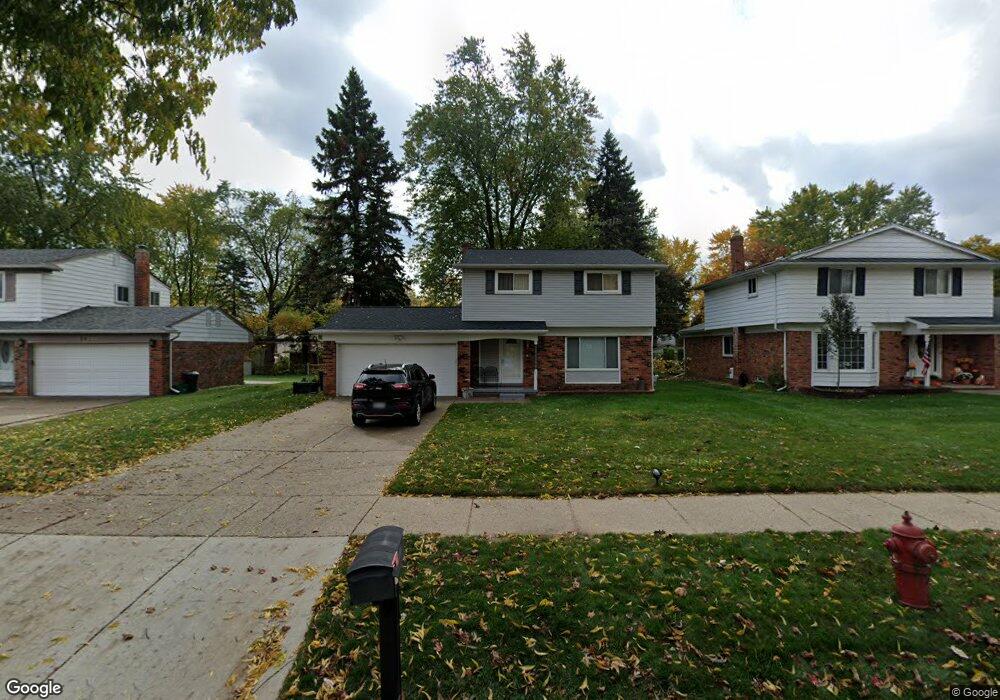
20195 Roseland St Southfield, MI 48076
Estimated Value: $234,000 - $334,000
4
Beds
2
Baths
1,580
Sq Ft
$190/Sq Ft
Est. Value
About This Home
This home is located at 20195 Roseland St, Southfield, MI 48076 and is currently estimated at $300,177, approximately $189 per square foot. 20195 Roseland St is a home located in Oakland County with nearby schools including Alice M. Birney K-8 School, Yeshivas Darchei Torah, and Farber Hebrew Day School.
Ownership History
Date
Name
Owned For
Owner Type
Purchase Details
Closed on
Oct 10, 2008
Sold by
Federal Home Loan Mortgage Corporation
Bought by
Mason Latonia M
Current Estimated Value
Purchase Details
Closed on
May 1, 2007
Sold by
Hardy Dwayne and Hardy Lisa L
Bought by
Federal Home Loan Mortgage Corporation
Purchase Details
Closed on
Sep 28, 2001
Sold by
Faraj Matti
Bought by
Hardy Dwayne
Home Financials for this Owner
Home Financials are based on the most recent Mortgage that was taken out on this home.
Original Mortgage
$171,000
Interest Rate
6.64%
Mortgage Type
Purchase Money Mortgage
Purchase Details
Closed on
Jun 3, 1997
Sold by
Garlick Andrew M
Bought by
Matti Faraj
Home Financials for this Owner
Home Financials are based on the most recent Mortgage that was taken out on this home.
Original Mortgage
$122,700
Interest Rate
8.13%
Mortgage Type
Purchase Money Mortgage
Create a Home Valuation Report for This Property
The Home Valuation Report is an in-depth analysis detailing your home's value as well as a comparison with similar homes in the area
Home Values in the Area
Average Home Value in this Area
Purchase History
| Date | Buyer | Sale Price | Title Company |
|---|---|---|---|
| Mason Latonia M | $55,000 | Attorneys Title Agency Llc | |
| Federal Home Loan Mortgage Corporation | $172,160 | None Available | |
| Hardy Dwayne | $180,000 | -- | |
| Matti Faraj | $128,000 | -- |
Source: Public Records
Mortgage History
| Date | Status | Borrower | Loan Amount |
|---|---|---|---|
| Previous Owner | Hardy Dwayne | $171,000 | |
| Previous Owner | Matti Faraj | $122,700 |
Source: Public Records
Tax History Compared to Growth
Tax History
| Year | Tax Paid | Tax Assessment Tax Assessment Total Assessment is a certain percentage of the fair market value that is determined by local assessors to be the total taxable value of land and additions on the property. | Land | Improvement |
|---|---|---|---|---|
| 2022 | $3,056 | $114,360 | $19,620 | $94,740 |
| 2021 | $3,133 | $99,360 | $19,620 | $79,740 |
| 2020 | $2,731 | $87,760 | $17,060 | $70,700 |
| 2018 | $3,230 | $73,510 | $17,060 | $56,450 |
| 2015 | -- | $54,670 | $0 | $0 |
| 2014 | -- | $46,960 | $0 | $0 |
| 2011 | -- | $47,070 | $0 | $0 |
Source: Public Records
Map
Nearby Homes
- 20141 Lacrosse Ave
- 20351 Lacrosse Ave
- 28450 Tapert Dr
- 19601 W 12 Mile Rd Unit 102
- 20120 Covington Pkwy
- 27925 Arlington Dr
- 21650 W 11 Mile Rd
- 29662 Westbrook Pkwy
- 20345 Harbor Ln
- 20780 Wayland St
- 18797 Wiltshire Blvd
- 29140 Candlewood Ln
- 21140 Winchester St
- 29585 Woodhaven Ln
- 29214 Candlewood Ln
- 27430 Evergreen Rd Unit 36
- 29743 Chelmsford Rd
- 21330 Winchester St
- 30130 Woodgate Dr
- 21440 Constitution St
- 20175 Roseland St
- 20209 Roseland St
- 20145 Roseland St
- 20170 Alhambra St
- 20225 Roseland St
- 20220 Alhambra St
- 20239 Roseland St
- 20115 Roseland St
- 20140 Alhambra St
- 20240 Alhambra St
- 20220 Roseland St
- 20110 Alhambra St
- 20251 Roseland St
- 20260 Alhambra St
- 28775 Evergreen Rd Unit Bldg-Unit
- 28775 Evergreen Rd
- 20109 W 12 Mile Rd
- 20250 Roseland St
- 20080 Alhambra St
- 20265 Roseland St