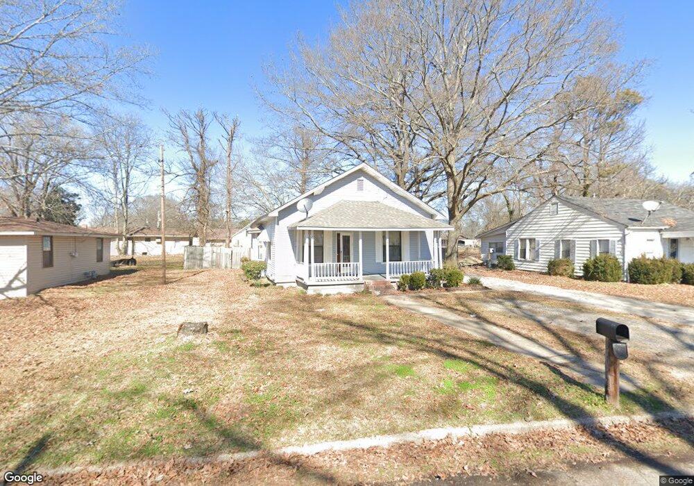
202 Ashcraft St Mc Gehee, AR 71654
Estimated Value: $64,707 - $163,000
--
Bed
1
Bath
1,203
Sq Ft
$82/Sq Ft
Est. Value
About This Home
This home is located at 202 Ashcraft St, Mc Gehee, AR 71654 and is currently estimated at $99,177, approximately $82 per square foot. 202 Ashcraft St is a home located in Desha County with nearby schools including McGehee Elementary School, Conner Middle School, and McGehee High School.
Ownership History
Date
Name
Owned For
Owner Type
Purchase Details
Closed on
Apr 18, 2025
Sold by
Commissioner Of State Lands
Bought by
Alexander Demarcus C
Current Estimated Value
Purchase Details
Closed on
Apr 26, 2023
Sold by
Commissioner Of State Lands
Bought by
Alexander Demarcus C
Purchase Details
Closed on
Sep 19, 2005
Sold by
Jamison Billy W and Jamison Stacia L
Bought by
Liang Rui Hao
Purchase Details
Closed on
Mar 27, 1989
Bought by
Billy and Stacia Jamison
Create a Home Valuation Report for This Property
The Home Valuation Report is an in-depth analysis detailing your home's value as well as a comparison with similar homes in the area
Home Values in the Area
Average Home Value in this Area
Purchase History
| Date | Buyer | Sale Price | Title Company |
|---|---|---|---|
| Alexander Demarcus C | $1,165 | None Listed On Document | |
| Alexander Demarcus C | $1,096 | None Listed On Document | |
| Liang Rui Hao | $36,500 | None Available | |
| Billy | $30,000 | -- |
Source: Public Records
Tax History Compared to Growth
Tax History
| Year | Tax Paid | Tax Assessment Tax Assessment Total Assessment is a certain percentage of the fair market value that is determined by local assessors to be the total taxable value of land and additions on the property. | Land | Improvement |
|---|---|---|---|---|
| 2025 | $466 | $8,820 | $1,200 | $7,620 |
| 2024 | $466 | $8,820 | $1,200 | $7,620 |
| 2023 | $466 | $8,820 | $1,200 | $7,620 |
| 2022 | $540 | $8,820 | $1,200 | $7,620 |
| 2021 | $503 | $8,220 | $1,200 | $7,020 |
| 2020 | $501 | $8,220 | $1,200 | $7,020 |
| 2019 | $72 | $8,220 | $1,200 | $7,020 |
| 2018 | $81 | $8,220 | $1,200 | $7,020 |
| 2017 | $59 | $8,220 | $1,200 | $7,020 |
| 2015 | -- | $6,280 | $1,200 | $5,080 |
| 2014 | -- | $6,280 | $1,200 | $5,080 |
| 2013 | -- | $6,280 | $1,200 | $5,080 |
Source: Public Records
Map
Nearby Homes
- 109 Ashcraft St
- 604 Highway 65 S
- Lot 2 Cypress Gardens
- 1104 U S 65
- Vacant land Cater Ln
- Lots 6-7 Bush St
- 6 Paul St
- 22 Orlando Dr
- Lot 1 S 1st St
- Lot 2 S 1st St
- 309 S 5th St
- 205 S 2nd St
- 209 Sherwood St
- 110 S Adams Ave
- 0 Masonville Rd Unit 25037306
- 1 Shannon Dr
- 1108 N 2nd St
- 32 Shannon Dr
- 1608 N 3rd St
- Lot 7 W Matthews St
- 200 Ashcraft St
- 204 Ashcraft St
- 206 Ashcraft St
- 108 Ashcraft St
- 113 Ashcraft St
- 111 Ashcraft St
- 208 Ashcraft St
- 209 Ashcraft St
- 106 Ashcraft St
- 107 Ashcraft St
- 210 Ashcraft St
- 201 Crooked Bayou Dr
- 207 Ashcraft St
- 105 Ashcraft St
- 212 Ashcraft St
- 112 Friedman St
- 207 Crooked Bayou Dr
- 103 Ashcraft St
- 202 Friedman St
- 106 Friedman St