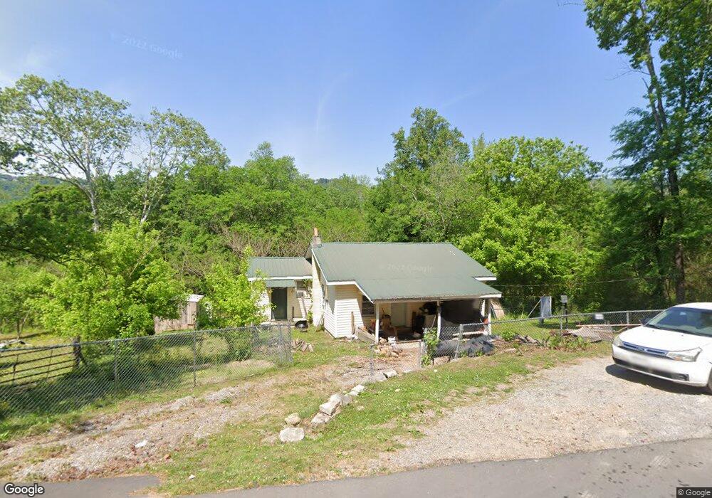
202 Burnt Mill Rd Flintstone, GA 30725
Flintstone NeighborhoodEstimated Value: $66,000 - $184,000
2
Beds
1
Bath
858
Sq Ft
$126/Sq Ft
Est. Value
About This Home
This home is located at 202 Burnt Mill Rd, Flintstone, GA 30725 and is currently estimated at $108,112, approximately $126 per square foot. 202 Burnt Mill Rd is a home located in Walker County with nearby schools including Chattanooga Valley Elementary School, Chattanooga Valley Middle School, and Ridgeland High School.
Ownership History
Date
Name
Owned For
Owner Type
Purchase Details
Closed on
Mar 29, 2022
Sold by
Walker David W
Bought by
Blakemore Forrest and Johnson Christopher Gilbert
Current Estimated Value
Purchase Details
Closed on
May 25, 2011
Sold by
Fnma
Bought by
Walker David
Purchase Details
Closed on
Jan 4, 2011
Sold by
Financial Freedon Acquisit
Bought by
Federal National Mtg Associati
Purchase Details
Closed on
Jul 21, 2005
Sold by
Not Provided
Bought by
Walker David
Purchase Details
Closed on
Jun 23, 1999
Sold by
Hunter Nelle
Bought by
Harris Charles W and Harris May G
Purchase Details
Closed on
Jan 5, 1983
Sold by
Hunter Roscoe
Bought by
Hunter Nelle
Purchase Details
Closed on
Jan 1, 1972
Bought by
Hunter Roscoe
Create a Home Valuation Report for This Property
The Home Valuation Report is an in-depth analysis detailing your home's value as well as a comparison with similar homes in the area
Home Values in the Area
Average Home Value in this Area
Purchase History
| Date | Buyer | Sale Price | Title Company |
|---|---|---|---|
| Blakemore Forrest | -- | -- | |
| Walker David | $11,000 | -- | |
| Federal National Mtg Associati | $28,353 | -- | |
| Financial Freedon Acquisition | $28,353 | -- | |
| Walker David | $32,500 | -- | |
| Harris Charles W | $25,000 | -- | |
| Hunter Nelle | -- | -- | |
| Hunter Roscoe | -- | -- |
Source: Public Records
Tax History
| Year | Tax Paid | Tax Assessment Tax Assessment Total Assessment is a certain percentage of the fair market value that is determined by local assessors to be the total taxable value of land and additions on the property. | Land | Improvement |
|---|---|---|---|---|
| 2024 | $623 | $24,542 | $6,168 | $18,374 |
| 2023 | $587 | $22,305 | $4,895 | $17,410 |
| 2022 | $474 | $16,546 | $1,772 | $14,774 |
| 2021 | $363 | $10,614 | $1,772 | $8,842 |
| 2020 | $343 | $9,494 | $1,772 | $7,722 |
| 2019 | $348 | $9,494 | $1,772 | $7,722 |
| 2018 | $251 | $9,494 | $1,772 | $7,722 |
| 2017 | $374 | $9,494 | $1,772 | $7,722 |
| 2016 | $266 | $5,547 | $1,772 | $3,775 |
| 2015 | $434 | $11,668 | $3,300 | $8,368 |
| 2014 | $359 | $11,668 | $3,300 | $8,368 |
| 2013 | -- | $11,667 | $3,300 | $8,367 |
Source: Public Records
Map
Nearby Homes
- 12 Burnt Mill Cir
- 914 Walker Rd
- 1297 Thomas Ave
- 1317 Thomas Ave Unit 8
- 1317 Thomas Ave
- 5719 Saint Elmo Ave
- 1360 Thomas Ave
- 1366 Thomas Ave
- 5685 Lee Ave
- 5706 Pumpkin Pie Ln
- 5501 Beulah Ave
- 5414 Dorsey St
- 5412 Dorsey St
- 5411 Saint Elmo Ave
- 000 Slayton Ave
- Lots 7 & 5 Slayton Ave
- 5405 Saint Elmo Ave
- 5205 Tennessee Ave
- 5204 Tennessee Ave
- 5110 Tennessee Ave
- 234 Burnt Mill Rd
- 153 Burnt Mill Rd
- 245 Burnt Mill Rd
- 258 Burnt Mill Rd
- 168 Burnt Mill Rd
- 269 Burnt Mill Rd
- 103 Burnt Mill Rd
- 103 Burnt Mill Rd Unit C
- 910 Burnt Mill Rd
- 343 Burnt Mill Rd
- 109 Burnt Mill Rd
- 64 Burnt Mill Rd
- 351 Burnt Mill Rd
- 101 Burnt Mill Rd
- 84 Burnt Mill Cir
- 11 Burnt Mill Cir
- 363 Burnt Mill Rd
- 90 Burnt Mill Cir
- 1234 Salem Rd
- 7 Burnt Mill Rd
Your Personal Tour Guide
Ask me questions while you tour the home.