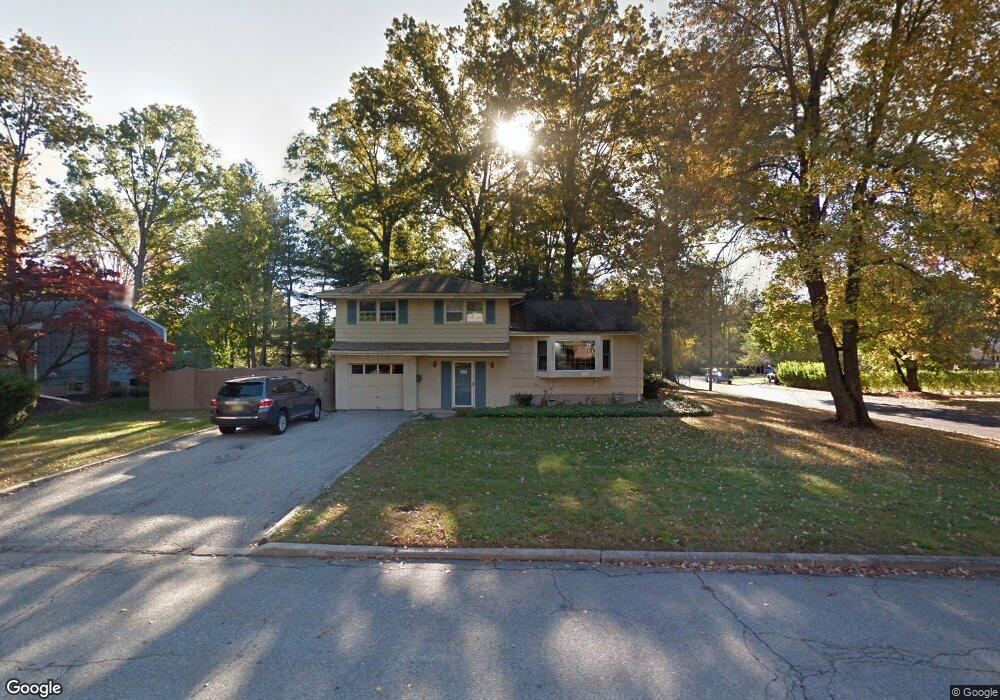
202 Dorian Rd Boonton, NJ 07005
Estimated Value: $610,000 - $752,000
--
Bed
--
Bath
1,600
Sq Ft
$432/Sq Ft
Est. Value
About This Home
This home is located at 202 Dorian Rd, Boonton, NJ 07005 and is currently estimated at $690,908, approximately $431 per square foot. 202 Dorian Rd is a home located in Morris County with nearby schools including School Street Elementary School, John Hill Elementary School, and Boonton High School.
Ownership History
Date
Name
Owned For
Owner Type
Purchase Details
Closed on
Dec 23, 2021
Sold by
Daryl Macaraya
Bought by
Macaraya-Taclob Daryl and Taclob Norman
Current Estimated Value
Home Financials for this Owner
Home Financials are based on the most recent Mortgage that was taken out on this home.
Original Mortgage
$388,000
Interest Rate
3.12%
Mortgage Type
New Conventional
Purchase Details
Closed on
May 21, 2009
Sold by
Meier Linda S and Meier Gary
Bought by
Macaraya Daryl
Home Financials for this Owner
Home Financials are based on the most recent Mortgage that was taken out on this home.
Original Mortgage
$381,550
Interest Rate
4.87%
Mortgage Type
FHA
Purchase Details
Closed on
Jan 12, 1996
Sold by
Bugin Lorenzo and Bugin Germana Carraro
Bought by
Crawford Peter F and Crawford Lynda S
Create a Home Valuation Report for This Property
The Home Valuation Report is an in-depth analysis detailing your home's value as well as a comparison with similar homes in the area
Home Values in the Area
Average Home Value in this Area
Purchase History
| Date | Buyer | Sale Price | Title Company |
|---|---|---|---|
| Macaraya-Taclob Daryl | -- | Rappaport David | |
| Macaraya-Taclob Daryl | -- | None Listed On Document | |
| Macaraya Daryl | $395,000 | Land Title Agency Inc | |
| Crawford Peter F | $205,500 | -- |
Source: Public Records
Mortgage History
| Date | Status | Borrower | Loan Amount |
|---|---|---|---|
| Previous Owner | Macaraya-Taclob Daryl | $388,000 | |
| Previous Owner | Macaraya Daryl | $381,550 |
Source: Public Records
Tax History Compared to Growth
Tax History
| Year | Tax Paid | Tax Assessment Tax Assessment Total Assessment is a certain percentage of the fair market value that is determined by local assessors to be the total taxable value of land and additions on the property. | Land | Improvement |
|---|---|---|---|---|
| 2025 | $11,948 | $353,500 | $207,600 | $145,900 |
| 2024 | $11,634 | $353,500 | $207,600 | $145,900 |
| 2023 | $11,634 | $353,500 | $207,600 | $145,900 |
| 2022 | $11,026 | $353,500 | $207,600 | $145,900 |
| 2021 | $11,026 | $353,500 | $207,600 | $145,900 |
| 2020 | $10,570 | $353,500 | $207,600 | $145,900 |
| 2019 | $10,708 | $353,500 | $207,600 | $145,900 |
| 2018 | $10,425 | $353,500 | $207,600 | $145,900 |
| 2017 | $9,990 | $353,500 | $207,600 | $145,900 |
| 2016 | $9,811 | $356,500 | $207,600 | $148,900 |
| 2015 | $9,650 | $356,500 | $207,600 | $148,900 |
| 2014 | $9,437 | $356,500 | $207,600 | $148,900 |
Source: Public Records
Map
Nearby Homes
- 18 Country Meadows Ln
- 18 Birdie Ln
- 95 Jesse Ct
- 7 Joan Dr
- 8 Highland Ave
- 19 Montville Ave
- 951 N Beverwyck Rd
- 9 Meadow Ct
- 34 Kanouse Ln
- 7 River Rd
- 14 Katherine Dr
- 303 Union St
- 203 N Beverwyck Rd Unit 1
- 203 1 N Beverwyck Rd Unit 1
- 209 William St
- 35 Millers Ln
- 725 Cornelia St
- 646 Cornelia St
- 630 Old Boonton Rd
- 34 Genoble Rd