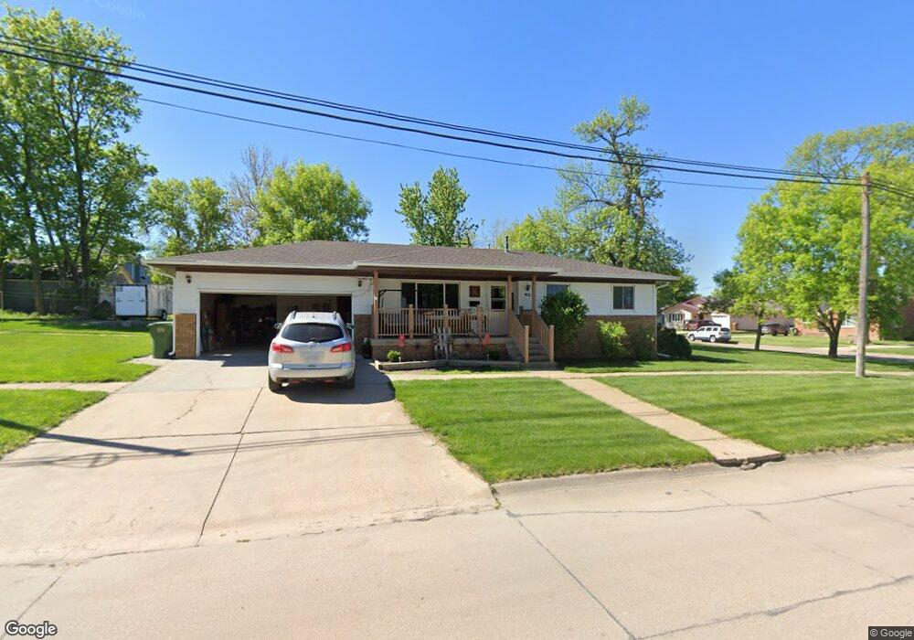
202 E Forrest St Sutton, NE 68979
Estimated Value: $193,000 - $213,047
3
Beds
2
Baths
1,082
Sq Ft
$189/Sq Ft
Est. Value
About This Home
This home is located at 202 E Forrest St, Sutton, NE 68979 and is currently estimated at $204,512, approximately $189 per square foot. 202 E Forrest St is a home located in Clay County with nearby schools including Sutton Elementary School, Sutton Secondary School, and Sutton Christian School.
Ownership History
Date
Name
Owned For
Owner Type
Purchase Details
Closed on
Nov 11, 2024
Sold by
Roth Randy
Bought by
Ramer Steven W and Ramer Nancy A
Current Estimated Value
Home Financials for this Owner
Home Financials are based on the most recent Mortgage that was taken out on this home.
Original Mortgage
$203,000
Outstanding Balance
$200,854
Interest Rate
6.32%
Mortgage Type
New Conventional
Estimated Equity
$3,658
Purchase Details
Closed on
Jun 14, 2016
Sold by
Reichert Vera
Bought by
Roth Randy
Create a Home Valuation Report for This Property
The Home Valuation Report is an in-depth analysis detailing your home's value as well as a comparison with similar homes in the area
Purchase History
| Date | Buyer | Sale Price | Title Company |
|---|---|---|---|
| Ramer Steven W | $210,000 | Adams Land Title | |
| Ramer Steven W | $210,000 | Adams Land Title | |
| Roth Randy | $105,000 | None Available |
Source: Public Records
Mortgage History
| Date | Status | Borrower | Loan Amount |
|---|---|---|---|
| Open | Ramer Steven W | $203,000 | |
| Closed | Ramer Steven W | $203,000 |
Source: Public Records
Tax History
| Year | Tax Paid | Tax Assessment Tax Assessment Total Assessment is a certain percentage of the fair market value that is determined by local assessors to be the total taxable value of land and additions on the property. | Land | Improvement |
|---|---|---|---|---|
| 2025 | $2,268 | $156,105 | $3,360 | $152,745 |
| 2024 | -- | $135,035 | $3,360 | $131,675 |
| 2023 | $0 | $135,035 | $3,360 | $131,675 |
| 2022 | $219 | $135,195 | $2,335 | $132,860 |
| 2021 | $2,405 | $127,675 | $2,335 | $125,340 |
| 2020 | $2,280 | $127,675 | $2,335 | $125,340 |
| 2019 | $1,944 | $109,465 | $2,335 | $107,130 |
| 2018 | $1,952 | $109,465 | $2,335 | $107,130 |
| 2017 | $1,886 | $109,465 | $2,335 | $107,130 |
| 2016 | $1,439 | $76,535 | $2,340 | $74,195 |
| 2015 | $1,506 | $76,535 | $2,340 | $74,195 |
| 2014 | -- | $76,535 | $2,340 | $74,195 |
| 2013 | -- | $76,535 | $2,340 | $74,195 |
Source: Public Records
Map
Nearby Homes
- 111 E Forrest St
- 209 E Grove St
- 403 S Way
- 502 S Maltby Ave
- 505 N Saunders Ave
- 512 N James Ave
- 712 S Maltby Ave
- 811 S Saunders Ave
- . Schwab Subdivision Lots
- 902 N Saunders Ave
- Lot 3 Wellman Schwab Subdivision Ave
- Road 315
- Sutton Unit NE 68979
- Parcel 3 Walnut St
- Parcel 2 Walnut St
- 1820 Road 6
- 1580
- 1580 Road 320
- 175 N Jackson Ave
- 235 E South St
- 106 S Maltby Ave
- 104 N Maltby Ave
- 105 S Way Ave
- 207 E Forrest St
- 108 N Maltby Ave
- 203 E Grove St
- 207 E Grove St
- 101 S Maltby Ave
- 103 S Maltby Ave
- 103 S Gray Ave
- 103 N Way Ave
- 105 S Maltby Ave
- 105 N Way Ave
- 110 N Maltby Ave
- 107 S Maltby Ave
- 107 N Way Ave
- 102 S Way Ave
- 105 N Maltby Ave
- 111 S Maltby Ave
- 206 E Elm St
Your Personal Tour Guide
Ask me questions while you tour the home.