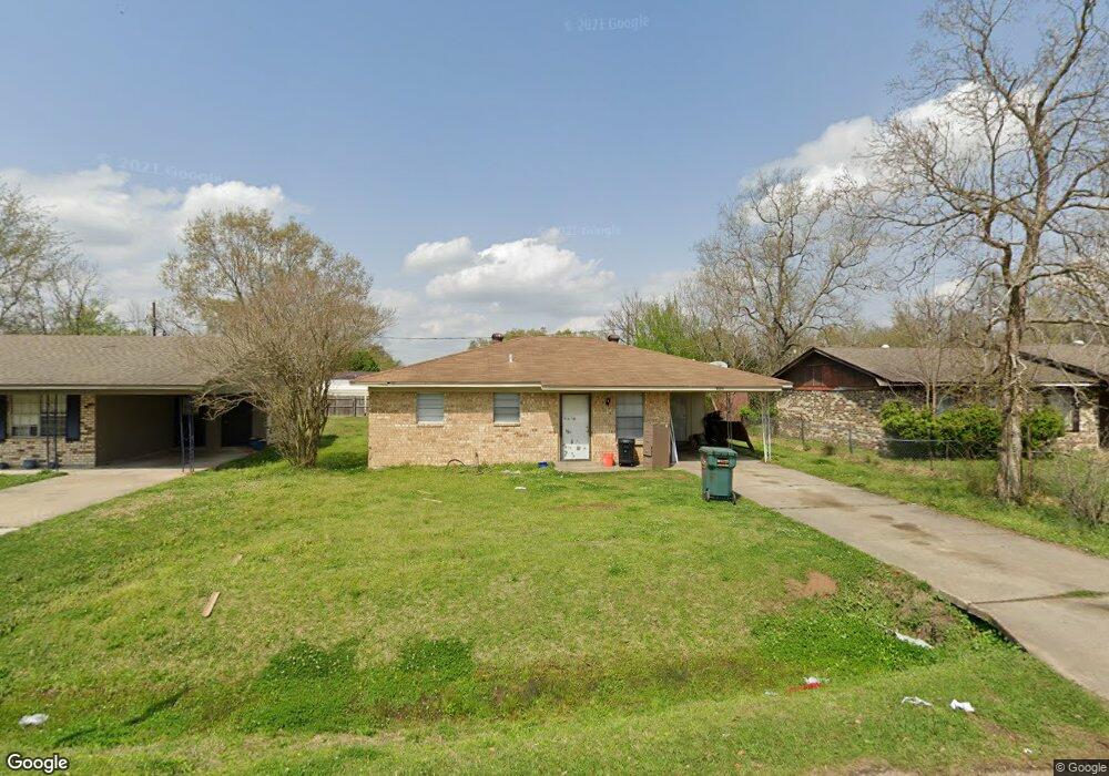
202 Harding Dr Monroe, LA 71203
Estimated Value: $60,000 - $109,000
3
Beds
1
Bath
1,044
Sq Ft
$81/Sq Ft
Est. Value
About This Home
This home is located at 202 Harding Dr, Monroe, LA 71203 and is currently estimated at $84,333, approximately $80 per square foot. 202 Harding Dr is a home located in Ouachita Parish with nearby schools including Swartz Lower Elementary School, Swartz Upper Elementary School, and Ouachita Junior High School.
Ownership History
Date
Name
Owned For
Owner Type
Purchase Details
Closed on
Mar 21, 2024
Sold by
Clampit Jonathan Scott and Gray Suzonne Denise
Bought by
Berry Kenneth W
Current Estimated Value
Home Financials for this Owner
Home Financials are based on the most recent Mortgage that was taken out on this home.
Original Mortgage
$337,620
Outstanding Balance
$331,021
Interest Rate
6.9%
Mortgage Type
Credit Line Revolving
Estimated Equity
-$246,688
Create a Home Valuation Report for This Property
The Home Valuation Report is an in-depth analysis detailing your home's value as well as a comparison with similar homes in the area
Purchase History
| Date | Buyer | Sale Price | Title Company |
|---|---|---|---|
| Berry Kenneth W | $32,000 | None Listed On Document |
Source: Public Records
Mortgage History
| Date | Status | Borrower | Loan Amount |
|---|---|---|---|
| Open | Berry Kenneth W | $337,620 |
Source: Public Records
Tax History
| Year | Tax Paid | Tax Assessment Tax Assessment Total Assessment is a certain percentage of the fair market value that is determined by local assessors to be the total taxable value of land and additions on the property. | Land | Improvement |
|---|---|---|---|---|
| 2025 | $328 | $2,300 | $200 | $2,100 |
| 2024 | $328 | $2,300 | $200 | $2,100 |
| 2023 | $330 | $2,300 | $200 | $2,100 |
| 2022 | $315 | $2,300 | $200 | $2,100 |
| 2021 | $317 | $2,300 | $200 | $2,100 |
| 2020 | $317 | $2,300 | $200 | $2,100 |
| 2019 | $313 | $2,300 | $200 | $2,100 |
| 2018 | $299 | $2,300 | $200 | $2,100 |
| 2017 | $306 | $2,300 | $200 | $2,100 |
| 2016 | $299 | $2,300 | $200 | $2,100 |
| 2015 | $299 | $2,300 | $200 | $2,100 |
| 2014 | $299 | $2,300 | $200 | $2,100 |
| 2013 | $298 | $2,300 | $200 | $2,100 |
Source: Public Records
Map
Nearby Homes
- 228 Eisenhower Dr
- 285 Stubbs Vinson Rd
- 306 Taylor Dr
- 374 Stubbs Vinson Rd
- 338 Bower Rd
- 200 Bennett Lake Dr
- 158 Barbara Dr
- 755 Highway 594
- 1077 Stubbs Vinson Rd
- 142 Jesse Ln
- 0 Braebend Dr
- 102 Patrick Place
- 2210 Highway 594
- 318 Monarch Dr
- 60 Nelson Rd
- 2238 Highway 594
- 0 Rowland Rd
- 300 Timber Way
- 142 Dallas Dr
- 138 Dallas Dr
- 204 Harding Dr
- 200 Harding Dr
- 206 Harding Dr
- 203 Eisenhower Dr
- 205 Eisenhower Dr
- 201 Eisenhower Dr
- 207 Eisenhower Dr
- 202 Van Buren Dr
- 208 Harding Dr
- 203 Harding Dr
- 205 Harding Dr
- 201 Harding Dr
- 207 Harding Dr
- 209 Eisenhower Dr
- 210 Harding Dr
- 206 Van Buren Dr
- 124 Van Buren Dr
- 211 Eisenhower Dr
- 117 Van Buren Dr
- 208 Van Buren Dr
Your Personal Tour Guide
Ask me questions while you tour the home.