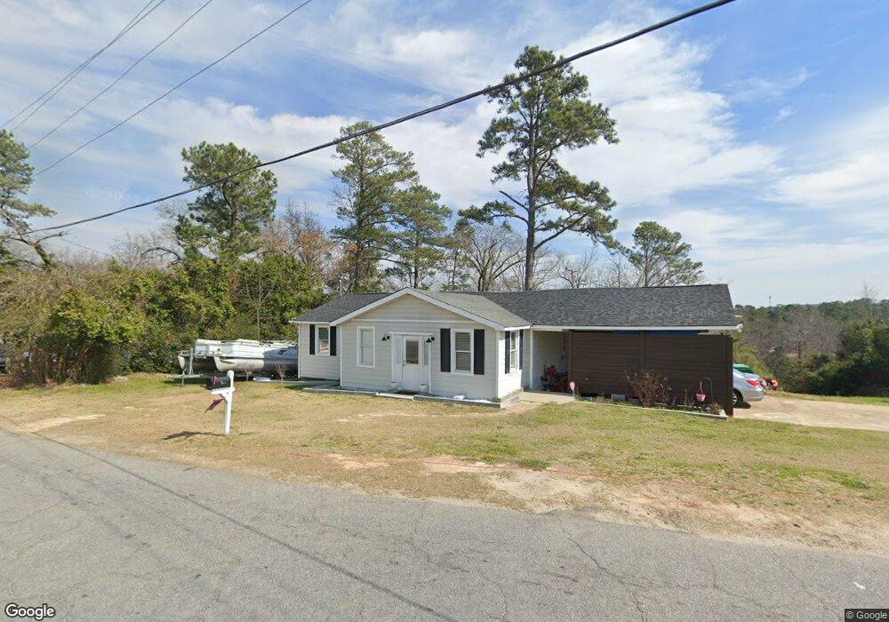
202 James St Grovetown, GA 30813
Estimated Value: $160,000 - $249,000
4
Beds
2
Baths
1,900
Sq Ft
$103/Sq Ft
Est. Value
About This Home
This home is located at 202 James St, Grovetown, GA 30813 and is currently estimated at $196,300, approximately $103 per square foot. 202 James St is a home located in Columbia County with nearby schools including Grovetown Elementary School, Grovetown Middle School, and Grovetown High School.
Ownership History
Date
Name
Owned For
Owner Type
Purchase Details
Closed on
Apr 5, 2024
Sold by
Le Jack
Bought by
Hubbard Robert
Current Estimated Value
Purchase Details
Closed on
Sep 16, 2022
Sold by
Hubbard Robert
Bought by
Le Jack and Anzure Daniel
Purchase Details
Closed on
Dec 12, 2001
Sold by
Cox Donald C and Vavallo Mary C
Bought by
Hubbard Robert
Home Financials for this Owner
Home Financials are based on the most recent Mortgage that was taken out on this home.
Original Mortgage
$69,150
Interest Rate
8.4%
Purchase Details
Closed on
Aug 14, 2001
Sold by
Hud
Bought by
Cox Donald C
Home Financials for this Owner
Home Financials are based on the most recent Mortgage that was taken out on this home.
Original Mortgage
$50,519
Interest Rate
7.08%
Purchase Details
Closed on
Apr 3, 2001
Sold by
Chase Manhattan Mtg Corp
Bought by
Hud
Create a Home Valuation Report for This Property
The Home Valuation Report is an in-depth analysis detailing your home's value as well as a comparison with similar homes in the area
Home Values in the Area
Average Home Value in this Area
Purchase History
| Date | Buyer | Sale Price | Title Company |
|---|---|---|---|
| Hubbard Robert | -- | -- | |
| Le Jack | -- | -- | |
| Hubbard Robert | $69,200 | -- | |
| Cox Donald C | -- | -- | |
| Hud | -- | -- | |
| Chase Manhattan Mtg Corp | $55,722 | -- |
Source: Public Records
Mortgage History
| Date | Status | Borrower | Loan Amount |
|---|---|---|---|
| Previous Owner | Hubbard Robert | $69,150 | |
| Previous Owner | Cox Donald C | $50,519 |
Source: Public Records
Tax History Compared to Growth
Tax History
| Year | Tax Paid | Tax Assessment Tax Assessment Total Assessment is a certain percentage of the fair market value that is determined by local assessors to be the total taxable value of land and additions on the property. | Land | Improvement |
|---|---|---|---|---|
| 2025 | $1,480 | $52,856 | $7,704 | $45,152 |
| 2024 | $1,537 | $52,100 | $7,704 | $44,396 |
| 2023 | $1,359 | $44,880 | $7,704 | $37,176 |
| 2022 | $1,313 | $42,618 | $7,704 | $34,914 |
| 2021 | $953 | $29,612 | $7,004 | $22,608 |
| 2020 | $973 | $29,702 | $6,404 | $23,298 |
| 2019 | $1,013 | $30,624 | $6,804 | $23,820 |
| 2018 | $1,047 | $31,156 | $6,804 | $24,352 |
| 2017 | $1,007 | $30,897 | $6,804 | $24,093 |
| 2016 | $971 | $30,583 | $6,780 | $23,803 |
| 2015 | $997 | $31,238 | $7,680 | $23,558 |
| 2014 | $1,006 | $31,193 | $7,680 | $23,513 |
Source: Public Records
Map
Nearby Homes
- 4917 Cavan Place
- 201 Williams St
- 100 Buck Ave
- 406 Williams St
- 106 Walton Dr
- 4907 Selkirk Way
- 1100 Durban Dr
- 102 Walton Dr
- 104 Bennett St
- 106 Bennett St
- 100 Walton Dr
- 116 Bennett St
- 118 Bennett St
- 132 Summerfield Cir
- 936 Bryan Cir
- 116 Summerfield Cir
- 321 Railroad Ave
- 636 Butler Springs Cir
- 125 Redford Dr
- 824 Shirez Dr