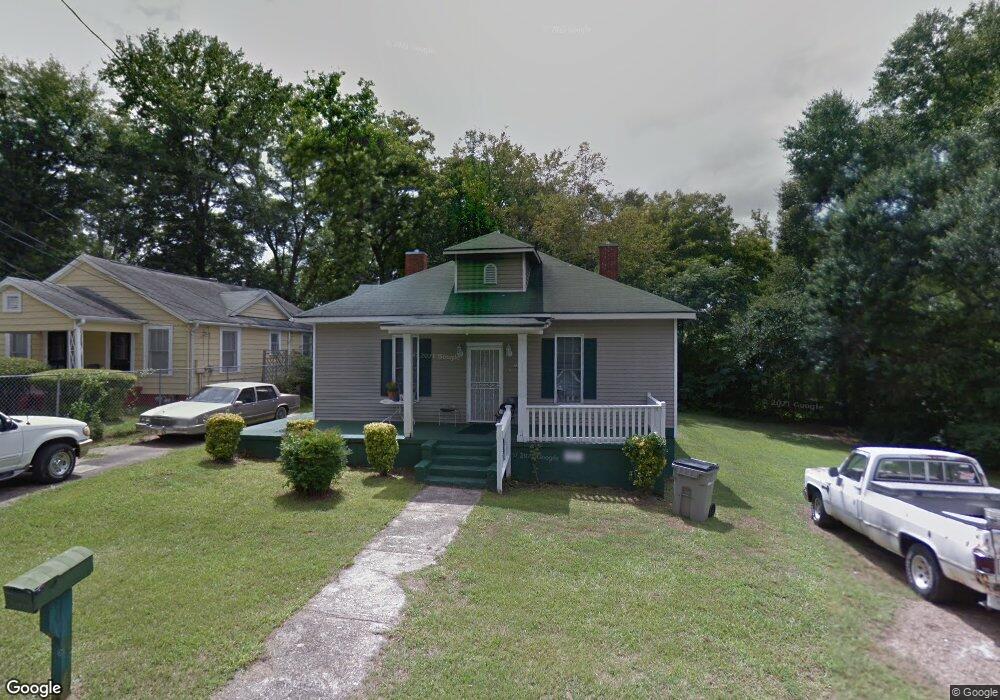
202 Johnson St Lagrange, GA 30241
Estimated Value: $64,000 - $107,809
3
Beds
2
Baths
1,356
Sq Ft
$60/Sq Ft
Est. Value
About This Home
This home is located at 202 Johnson St, Lagrange, GA 30241 and is currently estimated at $80,952, approximately $59 per square foot. 202 Johnson St is a home located in Troup County with nearby schools including Hollis Hand Elementary School, Franklin Forest Elementary School, and Ethel W. Kight Elementary School.
Ownership History
Date
Name
Owned For
Owner Type
Purchase Details
Closed on
Apr 19, 2019
Sold by
Najarian Capital Llc
Bought by
Alexander Eric and Alexander Monica
Current Estimated Value
Purchase Details
Closed on
Jan 16, 2003
Sold by
Gates Ronnie
Bought by
Gates David J
Purchase Details
Closed on
Aug 3, 2001
Sold by
Knopp Anthony E and Knopp Timothy V
Bought by
Gates Ronnie
Purchase Details
Closed on
Aug 16, 1996
Sold by
Mary R Maynard
Bought by
Knopp Anthony E and Knopp Timothy V
Purchase Details
Closed on
Jul 23, 1992
Sold by
Clara B Rosser Now Clara Brown
Bought by
Mary R Maynard
Purchase Details
Closed on
Oct 26, 1973
Sold by
Rosser Albert
Bought by
Clara B Rosser Now Clara Brown
Purchase Details
Closed on
Dec 7, 1961
Sold by
Rosser Albert Etal
Bought by
Rosser Albert
Create a Home Valuation Report for This Property
The Home Valuation Report is an in-depth analysis detailing your home's value as well as a comparison with similar homes in the area
Purchase History
| Date | Buyer | Sale Price | Title Company |
|---|---|---|---|
| Alexander Eric | $35,000 | -- | |
| Gates David J | -- | -- | |
| Gates Ronnie | $15,000 | -- | |
| Knopp Anthony E | $4,400 | -- | |
| Mary R Maynard | -- | -- | |
| Clara B Rosser Now Clara Brown | -- | -- | |
| Rosser Albert | -- | -- |
Source: Public Records
Tax History
| Year | Tax Paid | Tax Assessment Tax Assessment Total Assessment is a certain percentage of the fair market value that is determined by local assessors to be the total taxable value of land and additions on the property. | Land | Improvement |
|---|---|---|---|---|
| 2025 | $863 | $34,652 | $4,000 | $30,652 |
| 2024 | $812 | $31,780 | $4,000 | $27,780 |
| 2023 | $249 | $29,024 | $4,000 | $25,024 |
| 2022 | $709 | $27,384 | $4,000 | $23,384 |
| 2021 | $615 | $22,364 | $3,600 | $18,764 |
| 2020 | $419 | $27,080 | $3,600 | $23,480 |
| 2019 | $415 | $24,080 | $3,600 | $20,480 |
| 2018 | $666 | $24,080 | $3,600 | $20,480 |
| 2017 | $666 | $24,080 | $3,600 | $20,480 |
| 2016 | $646 | $23,388 | $3,600 | $19,788 |
| 2015 | $647 | $23,388 | $3,600 | $19,788 |
| 2014 | $615 | $22,299 | $3,600 | $18,699 |
| 2013 | -- | $23,796 | $3,600 | $20,196 |
Source: Public Records
Map
Nearby Homes
Your Personal Tour Guide
Ask me questions while you tour the home.